Royal Park railway station
Royal Park railway station is located on the Upfield railway line in Victoria, Australia. It serves the northern Melbourne suburb of Parkville, and opened on 9 September 1884.[1]
Royal Park | ||||||||||||||||||
|---|---|---|---|---|---|---|---|---|---|---|---|---|---|---|---|---|---|---|
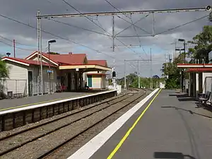
 Southbound view from Platform 2 | ||||||||||||||||||
| Location | Poplar Road, Parkville Australia | |||||||||||||||||
| Coordinates | 37°46′53″S 144°57′06″E | |||||||||||||||||
| Owned by | VicTrack | |||||||||||||||||
| Operated by | Metro | |||||||||||||||||
| Line(s) | Upfield | |||||||||||||||||
| Distance | 5.46 kilometres from Southern Cross | |||||||||||||||||
| Platforms | 2 side | |||||||||||||||||
| Tracks | 2 | |||||||||||||||||
| Connections | Bus Tram | |||||||||||||||||
| Construction | ||||||||||||||||||
| Structure type | Ground | |||||||||||||||||
| Disabled access | Yes | |||||||||||||||||
| Other information | ||||||||||||||||||
| Status | Unstaffed station | |||||||||||||||||
| Station code | RPK | |||||||||||||||||
| Fare zone | Myki zone 1 | |||||||||||||||||
| Website | Public Transport Victoria | |||||||||||||||||
| History | ||||||||||||||||||
| Opened | 9 September 1884 | |||||||||||||||||
| Electrified | Yes | |||||||||||||||||
| Services | ||||||||||||||||||
| ||||||||||||||||||
| ||||||||||||||||||
It is located in the park of the same name, and is the nearest station to the Melbourne Zoo. A disused signal box is located on Platform 1.
History
The original plan for the route of the line through Royal Park was to be east of the Zoological Gardens, but after local protests against the destruction of the park, a decision was made to build the line to the west for "reasons of economy". On opening, only temporary station buildings were provided, along with a signal box and gatekeepers cottage.[2]
On 8 May 1888, Royal Park became a junction station, with the opening of the Inner Circle line, to both Clifton Hill and Northcote. At the same time, a timber station building and station masters residence were erected. Between 1889 and 1912, there was a goods siding near the station, named Royal Park Cutting Siding.[2]
The current station building on the Platform 1 was opened in 1920, with a tile roof in the "Gisborne style", and in 1936, a new waiting shed and ticket office replaced earlier structures on Platform 2.[2] Boom barriers replaced interlocked gates at the Poplar Road level crossing in 1971, when automatic signaling reached the station from Jewell, with automatic signaling extended to Macaulay in 1972.[3] The Inner Circle line (by then a goods-only stub to Fitzroy) was closed in 1981, and the waiting shed on Platform 2 was destroyed by arson in 1989. The signal box on Platform 1 closed in 1994.[3]
Platforms & services
Royal Park has two side platforms. It is serviced by Metro Trains' Upfield line services.[4]
Platform 1:
- Upfield line: all stations services to Flinders Street
Platform 2:
- Upfield line: all stations services to Upfield
Transport links
Dysons operates one route via Royal Park station:
Yarra Trams operates one route via Royal Park station:
- 58: West Coburg to Toorak[6]
References
- Royal Park Vicsig
- Jon Saul and Wendy Moore (May 1990). Down the line to Upfield. Coburg Public Transport Group.
- Andrew Waugh. "VR History by Andrew Waugh - Upfield Line" (PDF). VR History. Retrieved 24 February 2009.
- "Upfield Line". Public Transport Victoria.
- "505 Moonee Ponds - Melbourne University via Parkville Gardens". Public Transport Victoria.
- "58 West Coburg - Toorak". Public Transport Victoria.
External links
 Media related to Royal Park railway station, Melbourne at Wikimedia Commons
- Melway map at street-directory.com.au