Rue Belliard
Rue Belliard (French) or Belliardstraat (Dutch) is a major street in Brussels, Belgium. The street runs parallel to Rue de la Loi/Wetstraat. Both are one-way streets; where traffic in Rue de la Loi runs in the western direction towards Brussels' city centre, Rue Belliard runs in the eastern direction, away from the city centre.
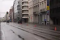 View of Rue Belliard on Belgian National Day | |
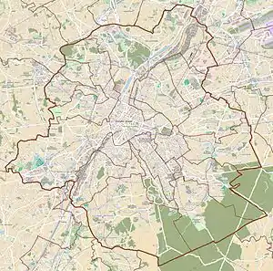 Location within Brussels | |
| Location | City of Brussels, Brussels-Capital Region, Belgium |
|---|---|
| Quarter | Leopold Quarter |
| Coordinates | 50°50′27″N 04°22′34″E |
The street runs from the east of the small ring road to the south-west corner of the Cinquantenaire Park. The street has 4 lanes from the small ring road to the start of the Belliard tunnel, 2 lanes along Leopold Park and ends on 1 lane up to the Cinquantenaire. The section on one lane from one park to the other is partly in the territory of the municipality of Etterbeek. The rest of the street is in the territory of the City of Brussels.
Rue Belliard is named after Augustin Daniel Belliard, a French general who was governor of the department of the Dyle.[1]
Buildings
The first part of Rue Belliard (from Avenue des Arts/Kunstlaan until Rue van Maerlant/Van Maerlantstraat) was opened in 1855, while the second part of the street (until the Cinquantenaire Park) was finished in 1869.[1]
- № 7: European Commission
- № 15–17: Embassy of Bosnia and Herzegovina
- № 25–33: National Lottery (Belgium)
- № 28: European Commission
- № 40: Odas Global Consulting Ltd.
- № 41–43: Permanent Representation of Lithuania to the European Union
- № 58: Goethe-Institut
- № 60–62 Permanent Representation of German State Baden-Württemberg to the European Union
- № 65: Red Cross (International Red Cross and Red Crescent Movement) European Union Office
- № 99–101: Delors building, home of the European Economic and Social Committee and Committee of the Regions
- № 100: European Commission
- № 135: European Parliament Eastman building
- № 137: Library of Solvay in Leopold Park
- № 199: Greenpeace EU unit