Russellville, Tennessee
Russellville is a census-designated place in Hamblen County, Tennessee, United States.[2] Located along U.S. Route 11E-Tennessee State Route 34 (US 11E/SR 34), it is situated approximately at a midpoint between Whitesburg and Morristown.[3]
Russellville, Tennessee | |
|---|---|
| Russellville | |
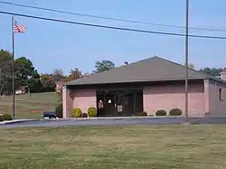 The post office in Russellville | |
 Russellville  Russellville | |
| Coordinates: 36°15′31″N 83°11′43″W | |
| Country | United States |
| State | Tennessee |
| County | Hamblen |
| Founded | 1784[1] |
| Elevation | 1,247 ft (380 m) |
| Time zone | UTC-5 (Eastern (EST)) |
| • Summer (DST) | UTC-4 (EDT) |
| ZIP codes | 37860 |
| Area code(s) | 423 |
| FIPS code | 47-47063[2] |
| GNIS feature ID | 2804642 |
History
Russellville was founded by George Russell in 1784. He had been granted a large tract of land in Greene County, North Carolina.[1]
During the American Civil War, Confederate Lieutenant General James Longstreet established a headquarters in the Nenney House in Russellville just after the Battle of Bean's Station in December 1863. His Confederate army used Russellville for their winter camp of 1863-64. The house still stands and has been converted into The General Longstreet Museum.[4] Also during that winter, General Lafayette McLaws was in quarters at a house now called "Hayslope", a house that also still stands and was originally a tavern built by the early settlers. It was originally called the Tavern with the Red Door, while General Joseph B. Kershaw was at the nearby Taylor plantation. The nearby Bethesda Presbyterian Church was used as a hospital during the Civil War and is listed on the National Register of Historic Places. It has many wartime burials, 80 of which are unidentified.[5][6]
In the mid and early twentieth century, Russellville was a hub for production and distribution of bootleg whiskey.
As of 2020, portions of the Russellville community, including an industrial park, have been annexed into the city limits of Morristown.[7]
Notable people
- Edward R. Talley, soldier; Medal of Honor recipient[8]
References
- Swain, Craig (December 13, 2009). "Russellville Area Historical Marker". Historical Marker Database. Retrieved September 12, 2020.
- "Russellville Census Designated Place". Geographic Names Information System. United States Geological Survey. Retrieved September 12, 2020.
- "Hamblen County" (PDF). Tennessee Department of Transportation. Long Range Planning Division. Retrieved September 12, 2020.
- "General James Longstreet, CSA". LongstreetMuseum.com. Retrieved June 11, 2020.
- "Bethesda Presbyterian Church: A Church Divided". The Historical Marker Database. Retrieved June 11, 2020.
- McRary, Amy (April 1, 2012). "Bethesda Church was first a hospital, then a casualty". Knoxville News Sentinel. Retrieved June 11, 2020.
- "Morristown Base Map (Zoning Map)". City of Morristown. Morristown-Hamblen GIS Department. Retrieved September 12, 2020.
- "Edward R. Talley". Find A Grave. Retrieved September 13, 2020.
Further reading
- Emma Dean Smith Trent (1987), East Tennessee's Lore of Yesteryear.
- Rebecca Dougherty Hyatt (1970), "History Around Russellville".
External links
Municipalities and communities of Hamblen County, Tennessee, United States | ||
|---|---|---|
| City | ||
| Town | ||
| Census-designated place | ||
| Unincorporated communities | ||
| Footnotes | ‡This populated place also has portions in an adjacent county or counties | |
| ||