Ruweng Administrative Area
The Ruweng Administrative Area is an administrative area in South Sudan. [3] The area was known as Ruweng State between 2 October 2015 and 22 February 2020 when it was a state of South Sudan. [4]
Ruweng Administrative Area
Tiop De loi gong ajuot | |
|---|---|
 Flag | |
| Nickname(s): Israel of South Sudan | |
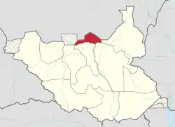 Location of the Ruweng Administrative Area in South Sudan | |
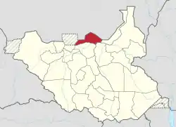 Location of Ruweng state (2015-2020) | |
| Country | South Sudan |
| Number of Counties | 2[1] |
| Capital | Pariang [2] |
| Government | |
| • Chief Administrator | TBA |
| Population (2014 Estimate) | |
| • Total | 246,360 |
History
On 1 October 2015, President Salva Kiir issued a decree establishing 32 states in place of the 10 constitutionally established states.[5] The decree established the new states largely along ethnic lines. A number of opposition parties and civil society groups challenged the constitutionality of the decree. Kiir later resolved to take it to parliament for approval as a constitutional amendment.[6] In November the South Sudanese parliament empowered President Kiir to create new states.[7] Mayol Kur Akuei , was appointed Governor on 2015.[8]
Chief Administrators
| Tenure | Incumbent | Party |
|---|---|---|
| 2005 – 30 December 2005 | Salva Kiir | SPLM |
| 30 December 2005 – 21 May 2011 | William Chol Awanlith | SPLM |
| May 2011 – 2015 | Mayol Kur Akuei | SPLM |
| 2015 – June 2020 | Kuol Deim Kuol | SPLM |
| June 2020 – present | William Chol Awanlith | SPLM |
Geography
The Ruweng Administrative Area is located in the northern part of South Sudan and its headquarters is at Pariang. It borders the former Fashoda State in the east and Fangak State in the southeast, Northern Liech State in the south, Twic State in the southwest, Abyei to the west, and Sudan in the north.
Economy
It is the most oil producing area in South Sudan, about 80% of South Sudanese oil is produced here, mainly in Unity / Darbim oil field (in the southern part), Heglig / Panthou oil field (in the north-western part), Tomasouth/Kaloj oilfield (in the western part) and Toor / Athony oil field or and other oil fields like Labob / Miading and Munga / Wan Danluel oilfield and Maan Awal and others fields .
Ruweng is rich in animal resources and fish resources, and it also is the home of two lakes: Lake Jau (in the northern part) and Lake No (in the southern part), where Bahr el Ghazal River ends and joins the White Nile.
Demographics
Ruweng is the home of Ruweng Dinkas which are Panaruu Dinka with 12 sub tribes and Aloor or Biemnom Dinka with 6 sub-tribes.
See also
References
- "Full list of Kiir's proposed new 28 states in S Sudan". Radio Tamazuj. 3 October 2015. Archived from the original on 5 March 2016. Retrieved 14 August 2016.
- "What exactly is Riek Machar is planning to achieve". Wël Yam. 1 August 2016. Retrieved 14 August 2016.
- https://www.aljazeera.com/news/2020/02/6-years-war-peace-finally-south-sudan-200223114919537.html
- https://twitter.com/dekuekd/status/1228596792155000833
- "Kiir and Makuei want 28 states in South Sudan". Radio Tamazuj. Archived from the original on 2015-12-08.
- "Kiir pressured into taking decree to parliament for approval". Radio Tamazuj. Archived from the original on 2016-03-04.
- "South Sudan's Kiir appoints governors of 28 new states". Sudan Tribune.
- "South Sudan's President appoints 28 Governors, defies peace agreement". South Sudan News Agency. 24 December 2015. Archived from the original on 2 February 2016.
|