Western Bahr el Ghazal
Western Bahr el Ghazal is a state in South Sudan. It has an area of 93,900 km2 (36,255 sq mi) and is the least populous state in South Sudan, according to the controversial Sudanese census conducted in 2008. It is part of the Bahr el Ghazal region. Its capital is Wau. The state shared international borders with Sudan to the north and the Central African Republic to the west. The portion now occupied by Raga County (pronounced 'Raja') is the southern part of the historical region known as "Dar Fertit".
Western Bahr el Ghazal | |
|---|---|
 Flag | |
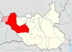 Location in South Sudan. | |
| Coordinates: 07°53′N 25°52′E | |
| Country | |
| Region | Bahr el Ghazal |
| Capital | Wau |
| Area | |
| • Total | 91,079.95 km2 (35,166.17 sq mi) |
| Population (2008) | |
| • Total | 333,431 |
| • Density | 3.7/km2 (9.5/sq mi) |
| Time zone | UTC+3 (EAT) |
| HDI (2018) | 0.445[1] low · 4th of 10 |
History
This state, and Raga County in particular, was the part of South Sudan that was most affected by the slave trade conducted by nearby Muslim sultanates from the 18th century on and by Mameluk Egypt in the second half of the 19th century, and Raga County is the only part of South Sudan with a significant number of Muslims and Arabs. In addition to the Baggara Arabs, another local Muslim ethnic group is the Feroghe (Feroge, etc.). Traditionally, the northern part of Raga County falls within the "Baggara belt", the 1400 kilometer wide section of the central Sahel in which cattle herding Arabic speaking tribes conduct seasonal nomadic migrations. When the slave trade soared in the 1860s and 1870s, the region's population shrank dramatically, plunging by 75 percent to about 400,000.[2] Depopulation was due to several factors all related to wars that were provoked by the upsurge in slaving promoted by Egypt, factors including: actual capture of inhabitants, emigration of refugees, and epidemics. The population according to the 2008 census was lower still. This may have been partly due to the second Sudanese civil war, 1983-1999, which devastated most of South Sudan, exacting a toll of two million dead civilians and hundreds of thousands of refugees.[3]
Demographics
Local ethnic groups included the Luo (The Original natives of Wau), and Balanda Boor, Balanda Bviri, Balanda Deim Zubeir (Balanda Viri, Balanda Bagari)( Balanda are one people settling in different locations hence Dem Zubier, Bagari, Bazia and Tambura are geographical names not tribal. they were found in both western Equatoria and Western Bahar El Ghazal states), Luo, Ndogo, Kresh, Bai, Baggara Arabs, and many others. Despite the common element "Balanda" in their names, the first two ethnicities are not related. Despite frequent mentions of the existence of a "Fertit people" in Western Bahr el Ghazal, there is no such people.[4]
Administration
Wau State, as with the other 28 states of South Sudan, was subdivided into counties; there were 8 counties, each headed by a County Commissioner:
| County | Area (km2) | Population Census 2008 | |
|---|---|---|---|
| Jur River | 10,032.22 | 127,771 | |
| Raga | 61,792.46 | 54,340 | |
| Wau | 19,251.27 | 151,320 |
The counties are further divided into Payams, then Bomas. South Sudan claims Kafia Kingi as part of Western Bahr el Ghazal with Sudan.
Main cities and towns
- Wau was the capital city of the state.
- Raga was located in the western part of the state.
- Acongeong was located northeast of Wau.
- Deim Zubeir was located in the central part of the state.
- Jur River was located in the central Wau
- Mapel was located in the eastern Wau
- Udici was located in the north-west of Wau
See also
Notes
- "Sub-national HDI - Area Database - Global Data Lab". hdi.globaldatalab.org. Retrieved 2020-04-18.
- Cordell 1983.
- One of them, Naomi Baki, has released an autobiography in French in 2013, in which she describes her 10 years journey as a refugee from Raga to France. Naomi Baki, Je suis encore vivante, Le Cerf, 2013
- Lewis 2010, p. 160.
References
- Cordell, Dennis (1983). "The savanna belt". In Birmingham, David; Martin, Phyllis M. (eds.). History of Central Africa. 1. Longman.CS1 maint: ref=harv (link)
- Thomas, Edward. 2010. The Kafia Kingi enclave. London and Nairobi: Rift Valley Institute.
|