Saguia el-Hamra
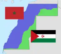
Saguia el-Hamra (Spanish: Saguía el Hamra, Arabic: الساقية الحمراء, romanized: al-Saqiyah al-Hamra'a, lit. 'Red Canal') was, with Río de Oro, one of the two territories that formed the Spanish province of Spanish Sahara after 1969. Its name comes from a waterway that goes through the capital. The wadi is inhabited by the Oulad Tidrarin Sahrawi tribe.
| Part of a series on the |
| Western Sahara conflict |
|---|
 |
| Background |
| Regions |
| Politics |
| Clashes |
| Issues |
| Peace process |

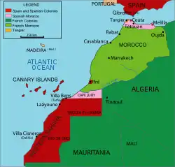
Occupying the northern part of Western Sahara, it lay between the 26th parallel north and 27°50'N. The city of Cape Bojador served to divide the regions. Its colonial capital was El Aaiún (Laâyoune),[1] and it also included the city of Smara.
The territory takes its name from an intermittent river, the Saguia el-Hamra, the route of which runs west from south of El Farcya to reach the Atlantic at Laayoune.
The area is roughly 82,000 km (51,000 mi), making it approximately a third of the entire Western Sahara.[2]
References
- Law, Gwillim (1999-10-01). Administrative Subdivisions of Countries: A Comprehensive World Reference, 1900 through 1998. McFarland. p. 412. ISBN 9780786460977.
- Great Soviet Encyclopedia. 1975. p. 447.