Saint-Eutrope
Saint-Eutrope is a former commune in the Charente department in southwestern France. On 1 January 2017, it was merged into the new commune Montmoreau.[2]
Saint-Eutrope | |
|---|---|
Part of Montmoreau | |
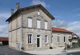 Town hall | |
Location of Saint-Eutrope 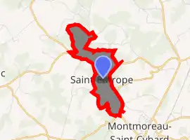
| |
 Saint-Eutrope  Saint-Eutrope | |
| Coordinates: 45°25′08″N 0°06′44″E | |
| Country | France |
| Region | Nouvelle-Aquitaine |
| Department | Charente |
| Arrondissement | Angoulême |
| Canton | Tude-et-Lavalette |
| Commune | Montmoreau |
| Area 1 | 2.67 km2 (1.03 sq mi) |
| Population (2017)[1] | 168 |
| • Density | 63/km2 (160/sq mi) |
| Time zone | UTC+01:00 (CET) |
| • Summer (DST) | UTC+02:00 (CEST) |
| Postal code | 16190 |
| Elevation | 114–186 m (374–610 ft) (avg. 183 m or 600 ft) |
| 1 French Land Register data, which excludes lakes, ponds, glaciers > 1 km2 (0.386 sq mi or 247 acres) and river estuaries. | |
Geography
Saint-Eutrope is a common South Charente located 2.5 km northwest of Montmoreau and 26 km south of Angoulême. It is a small town on the surface (less than 3 km2), and lying territory (3.5 km long and 0.5 km wide).
The village is 9 km southeast of Blanzac.
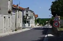
The town is crossed by two county roads. The main one is the D 10, drive to Montmoreau Blanzac and Chateauneuf, which runs through the town staying on the ridge. The other is the D 74 which joins the road to Angoulême Libourne (D 674) by Saint-Cybard and part of the town. It is also the route of Nonac in North Western Canada.2.
The nearest train station is in Montmoreau, served by TER to Angoulême and Bordeaux.
Hamlets and localities
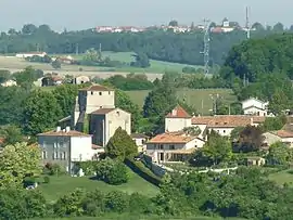
The village is quite large, and the town hamlets are small and are only farms: Bel-Air, Large Stones, Maine Blanchard, in Calais, Perry. Chabreville Castle, not far from the town, is in the municipality of Courgeac.
Geology
The ground is limestone Cretaceous (chalk), but the peaks are covered with sand and clay tertiary deposit, and wood (or heath) have chestnuts and pines, calcifuges species.
The clay of the ground meant that Saint-Eutrope was a renowned place of manufacture of solid pottery until the 20th Century, there was also an iron mine [3]
History
In the early sixteenth century, St. Eutrope de la Lande was a priory.[4] A Romanesque church dates from the twelfth century.
St. Eutropius was in the manor of Montmoreau dependent Angoumois, and following the religious wars, Francis has installed persecuted Catholic families, as well as Saint-Laurent-de-Belzagot.[5]
Saint-Eutrope has long been famous for its pottery. In the eighteenth century, no fewer than 30 families working there, with 25 fours. Saint-Eutrope specialized in the manufacture of large pieces: mass graves, Ponnes and flagons, as well as "faience pebbles" yellow glaze characteristics of certain workshops in the locality. This craft has reached its peak in 1841 with 140 potters. After the 1914-18 war, they were only a dizaine.[6]
The clay was then briefly operated as a building material (brickworks in Bel-Air, adopted in 1986).
Name
The first mention of the place appears in 1523: Sanctus Eutropius of Landa.[7] Saint Eutrope was the first bishop of Saintes, and his relics were the subject of pilgrimages in the Middle age.[8]
During the French Revolution, Saint-Eutrope was called La Poterie, and Utrope.
Dialects
Although the dialectal limit is 10 km to the east, the town also has the distinction of being a small enclave Occitan (Limousin dialect) language of oïl.[9][10]
Population
|
| ||||||||||||||||||||||||||||||||||||||||||||||||||||||||||||||||||||||||||||||||||||||||||||||||||||||||||||
| Source: EHESS[11] and INSEE (2007-2012)[12] | |||||||||||||||||||||||||||||||||||||||||||||||||||||||||||||||||||||||||||||||||||||||||||||||||||||||||||||
See also
References
- Téléchargement du fichier d'ensemble des populations légales en 2017, INSEE
- Arrêté préfectoral 29 June 2016 (in French)
- Jules Martin-Buchey, Géographie historique et communale de la Charente, édité par l'auteur, Châteauneuf, 1914-1917 (réimpr. Bruno Sépulchre, Paris, 1984), 422 p., p. 327
- Archives historiques de la Saintonge et de l'Aunis, Volume 35, (par Société des archives historiques de la Saintonge et de l'Aunis, 1905), p. 44
- Jean-Hippolyte Michon, Statistique monumentale de la Charente, Paris, Derache (réimprimé en 1980 par Bruno Sépulchre, (Paris), 1844), p334
- Jules Martin-Buchey, Géographie historique et communale de la Charente, édité par l'auteur, Châteauneuf, 1914-1917 (réimpr. Bruno Sépulchre, Paris, 1984), 422 p., p. 327
- Archives historiques de la Saintonge et de l'Aunis, Volume 35, (par Société des archives historiques de la Saintonge et de l'Aunis, 1905), p. 44
- Joël Guitton et al., Les chemins de Saint-Jacques en Charente, éditions Sud Ouest, 2010, p254.
- La langue occitane, Pierre Bec, Que sais-je, p. 11 : « Le village de St-Eutrope enfin (départ. Charente, entre Ribérac et Angoulême) forme une enclave limousine en domaine français. »
- Une colonie limousine en Saintonge, Saint-Eutrope, par Anatole Boucherie (éd. Maisonneuve, 1876)
- Données Cassini, EHESS
- Populations légales 2012, INSEE
| Wikimedia Commons has media related to Saint-Eutrope (Charente). |
| Authority control |
|---|