Saint-Gratien, Val-d'Oise
Saint-Gratien is a commune in the northern suburbs of Paris, France. It is located 13.8 km (8.6 mi) from the center of Paris.
Saint-Gratien | |
|---|---|
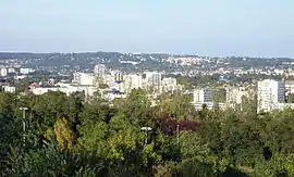 A general view of Saint-Gratien from the Orgemont hill | |
.svg.png.webp) Coat of arms | |
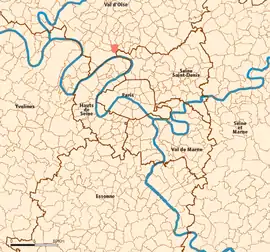 Location (in red) within Paris inner and outer suburbs | |
Location of Saint-Gratien 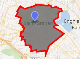
| |
 Saint-Gratien Location (in red) within Paris inner and outer suburbs  Saint-Gratien Saint-Gratien (Île-de-France (region)) | |
| Coordinates: 48°58′19″N 2°16′58″E | |
| Country | France |
| Region | Île-de-France |
| Department | Val-d'Oise |
| Arrondissement | Sarcelles |
| Canton | Argenteuil-1 |
| Intercommunality | CA Plaine Vallée |
| Government | |
| • Mayor (2020–2026) | Julien Bachard[1] |
| Area 1 | 2.42 km2 (0.93 sq mi) |
| Population | 20,682 |
| • Density | 8,500/km2 (22,000/sq mi) |
| Time zone | UTC+01:00 (CET) |
| • Summer (DST) | UTC+02:00 (CEST) |
| INSEE/Postal code | 95555 /95210 |
| 1 French Land Register data, which excludes lakes, ponds, glaciers > 1 km2 (0.386 sq mi or 247 acres) and river estuaries. | |
History
On August 7, 1850, a part of the territory of Saint-Gratien was detached and merged with a part of the territory of Deuil-la-Barre, a part of the territory of Soisy-sous-Montmorency, and a part of the territory of Épinay-sur-Seine to create the commune of Enghien-les-Bains. On that occasion the commune of Saint-Gratien lost the scenic lake now known as the Lake of Enghien.
Transport
Saint-Gratien is served by Saint-Gratien station on Paris RER line ![]() and by the
and by the ![]() bus number 138 going to Paris — Porte de Clichy.
bus number 138 going to Paris — Porte de Clichy.
References
- "Répertoire national des élus: les maires". data.gouv.fr, Plateforme ouverte des données publiques françaises (in French). 2 December 2020. Retrieved 12 December 2020.
- "Populations légales 2017". INSEE. Retrieved 6 January 2020.
External links
- Official website (in French)
- Base Mérimée: Search for heritage in the commune, Ministère français de la Culture. (in French)
- Association of Mayors of the Val d’Oise (in French)
| Wikimedia Commons has media related to Saint-Gratien (Val-d'Oise). |
| Authority control |
|---|
This article is issued from Wikipedia. The text is licensed under Creative Commons - Attribution - Sharealike. Additional terms may apply for the media files.