Paris metropolitan area
The Paris metropolitan area (French: aire urbaine de Paris, pronounced [ɛʁ yʁbɛn də paʁi]) is a statistical area that describes the reach of commuter movement to and from Paris, France and its surrounding suburbs.
Overview
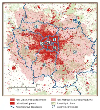
Created and used from 1996 by France's national INSEE statistical bureau to match international demographic standards,[1] the aire urbaine (literally: 'urban area') is a statistical unit that describes the suburban development around centres of urban growth:[2] it is composed of a couronne périurbaine (literally: 'peri-urban crown'; INSEE translation: 'rim') [3]) surrounding a more densely built and densely populated pôle urbain (or "urban cluster"[4]), which is a single or group of densely-built unité urbaine (literal and INSEE translation: "urban unit"[5]) communes.
From 2011, the INSEE classified its largest aires urbaines into aires métropolitaines (literally: metropolitan areas) and grandes aires urbaines ('large urban areas').[6] From then, the Paris metropolitan area became the largest metropolitan area in France.[7]
In France, the 'Paris metropolitan area' term's use is limited to demographic and statistical studies, and, to date, it is not used in economic statistics (the traditional commune, département and région administrative areas are still referenced for this), but in recent years the media has begun using it to describe the electoral tendencies of France's largest cities. In 2010 the government passed a law that invited France's largest city 'metropoles' to work together as an intercommunitary entities (more or less described by the INSEE concept),[8] but the lack of response by the following year moved the government to make the cooperation for many of France's largest cities obligatory, and Paris became a case study all on its own.[9]
This latter initiative created the "Métropole du Grand Paris" (official translation: 'Grand Paris metropolitan authority'), a Paris-centred intercommunal cooperation effort enacted from January 1, 2016.[10] The territory it covers is much smaller than the INSEE 'Paris metropolitan area' statistical area: it includes Paris, its neighbouring three départements (or 'petite couronne'), and a few bordering communes in the departments beyond.[11]
Extent
As of 2020, the INSEE statistical Paris metropolitan area covers 1771 communes.[12] With its 17,194 km2 (6,639 sq mi), it extends significantly beyond Paris' administrative Île-de-France region (12,012 km2 (4,638 sq mi)),[13] a region also commonly referred to as the région parisienne ("Paris Region"). Outside the Île-de-France region, it covers part of the departments Aisne, Eure, Eure-et-Loir, Loiret, Marne, Oise, Seine-Maritime and Yonne.[12]
Population
The area had a population of 12,628,266 as of 2017,[13] making it the largest urban region in the European Union. Nearly 19% of France's population resides in the region.
The Paris metropolitan area expands at each population census due to the rapid population growth in the Paris area. New communes (municipalities) surrounding Paris are included when they meet the 40% commuter threshold required. At the 1968 census, the earliest date for which population figures were retrospectively computed for French aire urbaines, the Paris metropolitan area had 8,368,459 inhabitants in an area that only encompassed central Île-de-France.[14]
By the 1999 census the Paris metropolitan area was slightly larger than Île-de-France and had 11,174,743 inhabitants in 14,518 km². By 2017 it had reached 12,628,266 inhabitants in 17,194 km², an area significantly larger than Île-de-France.[13]
Demographics
The table below shows the population growth of the Paris metropolitan area (aire urbaine), i.e. the urban area (pôle urbain) and the commuter belt (couronne périurbaine) surrounding it. (Note: the area shown in red and pink in the map above):
References
- Joubert, Guillaume; Lebrun, Vanessa (Jul 2, 2014). Histoire-Géographie Éducation civique 3e - Prépabrevet Cours & entraînement (in French). Hatier. p. 117. ISBN 978-2218962431. Retrieved 5 April 2017.
- "INSEE - Definitions - Urban area". INSEE. INSEE. Retrieved 5 April 2017.
- Definitions and methods: Rim
- Definitions and methods: Urban Cluster
- "Insee - definitions - Urban Unit". INSEE. Retrieved 5 April 2017.
- "An administrative segmentation of French territory: 12 metropolitan areas, 29 large urban areas". INSEE. INSEE. Retrieved 5 April 2017.
- "INSEE PREMIERE" (PDF) (in French) (N° 1333). January 2011: 2. Retrieved 5 April 2017. Cite journal requires
|journal=(help) - "LOI n° 2010-1563 du 16 décembre 2010 de réforme des collectivités territoriales". legifrance.gouv.fr. Retrieved 5 April 2017.
- "Affirmation des Metropoles et Grand Paris" (PDF) (in French). May 2014. p. 1.1. Archived from the original (PDF) on 3 March 2016. Retrieved 5 April 2017.
- "Métropole du Grand Paris - English version". Métropole du Grand Paris. Retrieved 5 April 2017.
- "Carte des territoires". Métropole du Grand Paris. Retrieved 5 April 2017.
- Aire urbaine de Paris (001), INSEE
- Comparateur de territoire: Aire urbaine de Paris (001), Île-de-France (11)
- Philippe Julien. "Mesurer un univers urbain en expansion" (PDF) (in French). INSEE. p. 11. Retrieved 2013-09-22.
External links
- (in French) Document about the functioning of Paris Metropolitan Area
- (in French) Document about the extension of Paris Metropolitan Area
 | ||