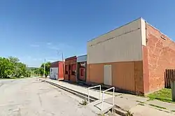
Salem, Nebraska
Salem is a village in Richardson County, Nebraska, United States. The population was 112 at the 2010 census.
Salem, Nebraska | |
|---|---|
 | |
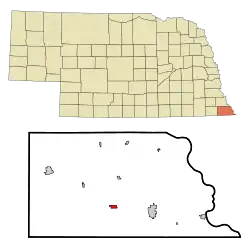 Location of Salem, Nebraska | |
| Coordinates: 40°4′36″N 95°43′23″W | |
| Country | United States |
| State | Nebraska |
| County | Richardson |
| Area | |
| • Total | 0.62 sq mi (1.61 km2) |
| • Land | 0.62 sq mi (1.61 km2) |
| • Water | 0.00 sq mi (0.00 km2) |
| Elevation | 971 ft (296 m) |
| Population | |
| • Total | 112 |
| • Estimate (2019)[3] | 104 |
| • Density | 167.47/sq mi (64.69/km2) |
| Time zone | UTC-6 (Central (CST)) |
| • Summer (DST) | UTC-5 (CDT) |
| ZIP code | 68433 |
| Area code(s) | 402 |
| FIPS code | 31-43370[4] |
| GNIS feature ID | 0833121[5] |
History
Salem was laid out in 1855.[6] Salem is derived from the Hebrew word shalom, meaning "peace".[7] It was incorporated as a city in 1856.[8]
Geography
Salem is located at 40°4′36″N 95°43′23″W (40.076576, -95.722930).[9]
According to the United States Census Bureau, the village has a total area of 0.62 square miles (1.61 km2), all land.[10]
Demographics
| Historical population | |||
|---|---|---|---|
| Census | Pop. | %± | |
| 1870 | 304 | — | |
| 1880 | 473 | 55.6% | |
| 1890 | 504 | 6.6% | |
| 1900 | 533 | 5.8% | |
| 1910 | 391 | −26.6% | |
| 1920 | 373 | −4.6% | |
| 1930 | 387 | 3.8% | |
| 1940 | 380 | −1.8% | |
| 1950 | 341 | −10.3% | |
| 1960 | 261 | −23.5% | |
| 1970 | 214 | −18.0% | |
| 1980 | 221 | 3.3% | |
| 1990 | 160 | −27.6% | |
| 2000 | 138 | −13.7% | |
| 2010 | 112 | −18.8% | |
| 2019 (est.) | 104 | [3] | −7.1% |
| U.S. Decennial Census[11] | |||
2010 census
As of the census[2] of 2010, there were 112 people, 52 households, and 28 families residing in the village. The population density was 180.6 inhabitants per square mile (69.7/km2). There were 73 housing units at an average density of 117.7 per square mile (45.4/km2). The racial makeup of the village was 99.1% White and 0.9% Native American.
There were 52 households, of which 21.2% had children under the age of 18 living with them, 46.2% were married couples living together, 3.8% had a female householder with no husband present, 3.8% had a male householder with no wife present, and 46.2% were non-families. 40.4% of all households were made up of individuals, and 23% had someone living alone who was 65 years of age or older. The average household size was 2.15 and the average family size was 2.96.
The median age in the village was 49.8 years. 17.9% of residents were under the age of 18; 6.3% were between the ages of 18 and 24; 19.8% were from 25 to 44; 33% were from 45 to 64; and 23.2% were 65 years of age or older. The gender makeup of the village was 49.1% male and 50.9% female.
2000 census
As of the census[4] of 2000, there were 138 people, 65 households, and 39 families residing in the village. The population density was 221.6 people per square mile (85.9/km2). There were 79 housing units at an average density of 126.8 per square mile (49.2/km2). The racial makeup of the village was 96.38% White, 0.72% African American, 0.72% Native American, 0.72% from other races, and 1.45% from two or more races. Hispanic or Latino of any race were 1.45% of the population.
There were 65 households, out of which 18.5% had children under the age of 18 living with them, 52.3% were married couples living together, 4.6% had a female householder with no husband present, and 40.0% were non-families. 36.9% of all households were made up of individuals, and 21.5% had someone living alone who was 65 years of age or older. The average household size was 2.12 and the average family size was 2.79.
In the village, the population was spread out, with 18.8% under the age of 18, 5.1% from 18 to 24, 28.3% from 25 to 44, 29.0% from 45 to 64, and 18.8% who were 65 years of age or older. The median age was 44 years. For every 100 females, there were 102.9 males. For every 100 females age 18 and over, there were 103.6 males.
As of 2000 the median income for a household in the village was $28,500, and the median income for a family was $36,875. Males had a median income of $26,250 versus $19,792 for females. The per capita income for the village was $13,325. There were 7.1% of families and 13.9% of the population living below the poverty line, including 3.8% of under eighteens and 5.0% of those over 64.
Notable person
- Tacy Atkinson, Christian missionary, was born in Salem.
References
- "2019 U.S. Gazetteer Files". United States Census Bureau. Retrieved July 26, 2020.
- "U.S. Census website". United States Census Bureau. Retrieved 2012-06-24.
- "Population and Housing Unit Estimates". United States Census Bureau. May 24, 2020. Retrieved May 27, 2020.
- "U.S. Census website". United States Census Bureau. Retrieved 2008-01-31.
- "US Board on Geographic Names". United States Geological Survey. 2007-10-25. Retrieved 2008-01-31.
- "Salem, Richardson". Center for Advanced Land Management Information Technologies. University of Nebraska. Retrieved 22 August 2014.
- Boye, Alan (2007). The Complete Roadside Guide to Nebraska. University of Nebraska Press. p. 4.
- Edwards, Lewis Clifford (1917). History of Richardson County, Nebraska: Its People, Industries and Institutions : with Biographical Sketches of Representative Citizens and Genealogical Records of the Old Families. Unigraphic. p. 730.
- "US Gazetteer files: 2010, 2000, and 1990". United States Census Bureau. 2011-02-12. Retrieved 2011-04-23.
- "US Gazetteer files 2010". United States Census Bureau. Archived from the original on 2012-07-02. Retrieved 2012-06-24.
- "Census of Population and Housing". Census.gov. Retrieved June 4, 2015.
Municipalities and communities of Richardson County, Nebraska, United States | ||
|---|---|---|
| Cities | Map of Nebraska highlighting Richardson County | |
| Villages | ||
| Unincorporated communities | ||
| Indian reservations | ||
| Footnotes | ‡This populated place also has portions in an adjacent county or counties | |
| ||