Salimabad Union
Salimabad Union is a union of Nagarpur Upazila, Tangail District, Bangladesh. It is situated 6 km west of Nagarpur Upazila headquarter on the bank of Jamuna River.
Salimabad Union
সলিমাবাদ ইউনিয়ন | |
|---|---|
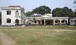 Salimabad Union Parishad | |
 Salimabad Union Location of Salimabad in Bangladesh | |
| Coordinates: 24°2′58.8694″N 89°48′41.5908″E | |
| Country | Bangladesh |
| Division | Dhaka Division |
| District | Tangail District |
| Upazila | Nagarpur Upazila |
| Established on | 1984 |
| Government | |
| • Type | Union Council |
| • Chairman | Md Daudul Islam Miah (Bangladesh Awami League
Union Parishad Sochib : Abu Kayes 01318255479 </ref> |
| Area | |
| • Total | 17 km2 (7 sq mi) |
| Elevation | 12 m (39 ft) |
| Population (2011) | |
| • Total | 21,674 |
| • Density | 1,300/km2 (3,300/sq mi) |
| Time zone | UTC+6 (BST) |
| Postal code | 1938 |
| Website | solimabadup |
Population
According to Population Census 2011 performed by Bangladesh Bureau of Statistics, The total population of Salimabad union is 21,674. There are 5042 households in total. Largest village in terms of population and area is Salimabad.
| Village | Total households | Population |
|---|---|---|
| Salimabad | 1573 | 6385 |
| Tebaria | 987 | 4209 |
| Char Ghunipara | 684 | 3351 |
| Tarfram Ghunipara | 1113 | 4702 |
| Paiksha | 342 | 1521 |
| Maijhail | 343 | 1506 |
Administration
The centre of the union is Salimabad Bazar. The union parishad complex is also situated here. There are 6 villages in this union. These are-
- Salimabad
- Tarfram Ghunipara
- Tebaria
- Char Ghunipara
- Paiksha
- Maijhail
Education
The literacy rate of Salimabad Union is 50.4% (Male-51.6%, Female-49.4%).[2]
There are several government financed primary schools in Salimabad. These are-
- Salimabad Chunabari govt. primary school
- Salimabad purbopara govt. primary school
- Salimabad uttarpara govt. primary school
- Tebaria govt. primary school
- Ghunipara govt. primary school
- Khasghunipara govt. primary school
- Paiksha-Maijhail govt. primary school
There are few high schools. These are-
- Salimabad union govt girls' high school
- Salimabad-Tebaria Islamia high school
- Ghunipara high school
- Freedom fighter Anwar Khan high school
See also
References
- "Tangail Table C-01 : Area, Households, Population, Density by Residence and Community" (PDF). bbs.gov.bd. Archived from the original (PDF) on 2014-11-13. Retrieved 2016-03-01.
- "Tangail : C06 : Distribution of Population aged 7 years and above by Literacy, Sex, Residence and Community" (PDF). bbs.gov.bd. Archived from the original (PDF) on 2014-11-13. Retrieved 2016-02-25.