Tangail
Tangail (Bengali: টাঙ্গাইল, [ʈaŋgail]), formerly Arail, is a major city within the Dhaka Division in central Bangladesh.[2] It sits on the bank of the Louhajang River,[3] 98 kilometres (61 mi) north-west of Dhaka, the nation's capital.[4] It is considered to be the main urban area of the Tangail District, and is the 25th-largest city by population in Bangladesh.
Tangail
টাঙ্গাইল | |
|---|---|
| Tangail | |
| Bangla transcription(s) | |
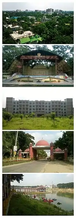 From top to bottom: 1. The city skyline from "Suparibagan"; 2. The Open Stage of Tangail Poura Uddan; 3. Tangail District Court Building; 4. The city gate, Shamsul Huq Toron"; 5. DC Lake at District Headquarters | |
| Nickname(s): Tangail City | |
 Tangail Location of Tangail in Bangladesh | |
| Coordinates: 24.264423°N 89.918140°E | |
| Country | Bangladesh |
| Division | Dhaka Division |
| District | Tangail District |
| Upazila | Tangail Sadar Upazila |
| Incorporated | 1887 |
| Government | |
| • Type | Pourashava |
| • Present Mayor | Md.Jamilur Rahman Miron (Bangladesh Awami League) |
| Area | |
| • Total | 29.04 km2 (11.21 sq mi) |
| Elevation | 14 m (46 ft) |
| Population (2017) | |
| • Total | |
| Time zone | UTC+6 (BST) |
| Postal codes | 1900, 1901, 1902 |
| Area code(s) | 0921 |
| Website | tangailpourashava |
| [1] | |
Etymology
The name Tangail is thought to originate from the Bengali word tanga, meaning horse carts; long lines of horse carts were common in the area in the early 19th century,[5] as these were the favored mode of transport for passengers and cargo.
History
Tangail has been a popular local business center since the early 19th century.[6] In 1860, Tangail became the central area of the Greater Mymensingh region due to its fertile land and high elevation near the Louhajong River.
The Pourasabha (municipal corporation) was established on July 1, 1887, and originally divided the city into five wards:
| Ward No. | Area |
|---|---|
| 1 | Tangail Kanda Para, Par Dighulia, Akur Takur Para |
| 2 | Korer Betka, Mirer Betka, Nondir Betka, Sabalia, Dorun, Ashekpur, Nagor Jalfai, Boali |
| 3 | Garai, Berai, Kazipur, Bachrakandi, Potol, Bajitpur, Berabuchna, Valluk kandi |
| 4 | Kagmari, Sontosh, Aloa, Boitta, Patuli, Ekrampur |
| 5 | Kalipur, Dighulia, Sakrail, Kaiyamara, Beradoma, Basha, Khanpur |
This was later restructured to four wards - Ward No. 1 (Central), 2 (Betka), 3 (Dighulia) and 4 (Santosh) - and then, in 1988, to six wards with the addition of Wards 5 (Zila Sadar) and 6 (Kazipur).
The first city election was held in November 1887 where eight ward commissioners from four wards were elected by the citizens. The Subdivision Commissioner of Tangail, Shashi Shekhar Dutt, was appointed as the first administrator of Tangail city. The city was poorly developed with a lack of paved roads and roadside lamps; subsequently, the regional zamindars and subdivision board provided financial support to dig ponds, lakes, and canals, which created a safe water supply.[7]
In the early 1900s, the Pourashava installed kerosene roadside lamps. The Pourashava gradually became populated in the first half of the 20th century. During this time, many tube wells were set up in the city and the main modes of transportation were horsecars and cattle.[8]
Electricity was established in the city in the early 1930s. Paved roads were constructed in the 1960s, connecting the city to Dhaka. Simultaneously, bridges and culverts were installed.[9]
In 1985, Tangail was promoted from a C Class city to a B Class city. In 1989, the Pourashava was promoted to A-Class. In the 1990s, the city was financed by the Asian Development Bank and the Government of Bangladesh to develop water supply, sanitation, wastewater drainage, bus terminals, supermarkets, and other infrastructure.[10]
In 1999, the city was restructured again into 18 wards (its current organization).[11]
Wards
Tangail has an area of 35.22 square kilometres (13.60 sq mi), divided into 18 wards and 64 mahallas.[12]
| Ward No. | Region | Households | Population (2011) |
|---|---|---|---|
| 1 | Akur Takur Para-north, Dewla, District hq | 2070 | 10388 |
| 2 | Enayetpur | 2142 | 8760 |
| 3 | West Akur Takur Para, North Kagmara, South Kagmara | 3205 | 13903 |
| 4 | Bepari Para, Fakir Para, Bera Doma, Dighulia, Char Dighulia | 2119 | 9208 |
| 5 | Kalipur, Lakshimpur, Sarutia, Shakrail | 1614 | 7235 |
| 6 | College Para, Paradise Para, Par Dighulia-part | 1569 | 6712 |
| 7 | Baluk Kandi, Bagbari, Patuli Bhabani Bagbari, Uttar Santosh-part, Santosh Palpara | 1674 | 7325 |
| 8 | Aloa Bhabani Pahim, Aloa Pahim, Dakshin Santosh-part | 1797 | 8026 |
| 9 | Aloa Baratia, Aloa Paikasta, Aloa Tarini, Baluk Kandi-part, Char Patuli, Purba Aloa, Aloa Bhabani | 1888 | 8575 |
| 10 | Bajitpur, Berai, Basrakandi, Kazipur, Patal | 1458 | 6189 |
| 11 | Berabuchna, Kachua Para,Kanda Para | 1929 | 7536 |
| 12 | Adi Tangail, Bepari Para, Bil Para | 1628 | 7160 |
| 13 | Tangail Mahalla, Chayanir Bazar, Pachanir Bazar, Thana Para, Uttar Thana Para | 1792 | 7572 |
| 14 | Purba Adalat Para, Adalat Para, Biswas Betka-part S.W corn, Shaha Para | 2790 | 11786 |
| 15 | Ashekpur, Biswas Betka-part | 2745 | 12118 |
| 16 | Akur Takur Para-part, Par Dighulia-part | 2459 | 10670 |
| 17 | Kumudini College Para, Munshi Para, Registry Para, Biswas Betka-west | 2128 | 11081 |
| 18 | Kodalia, Sabalia | 2600 | 13168[13] |
The Bangladeshi government is planning to expand the city to a total area of 81.75 km2.
Demographics
Tangail had 700000 residents as of 2017.
The majority of this population are Muslim (88.2%), like most of the cities in Bangladesh. Other religious groups include Hindus (11.7%), Christians (0.08%) and Buddhists (0.02%).
Sports
In the centre of the city, Tangail Stadium hosts the city's most important sporting events. The stadium has hosted national events. It is the home venue of Bangladesh Football Premier League club Team BJMC. It was converted into a cricket stadium in 2015 and regularly hosts First Division Cricket.[15]
Transport

Bangabandhu Bridge, the longest bridge in Bangladesh, connects Tangail and Sirajganj.[16]
It takes approximately 1 hour and 55 minutes to reach Tangail from Dhaka (about 98 km away), via Kaliakair and Tongi. Several bus lines operate between Tangail and Dhaka's Mohakhali (মহাখালী) bus terminal. Among them are the Nirala, Dhaleshwari, Jathika, and High Choice bus lines.
Tangail railway station offers travel to Dhaka and other cities within Bangladesh. The inter-city Ekota Express, Sundarban Express and Rangpur Express (amongst others) serve the station alongside commuter rail and mail train services.[17]
Tangail Airport was opened in 1967 for agricultural purposes but has been unmaintained since 1976.
Parks
Tangail contains numerous parks, including Tangail Poura Uddan (one of the city's most-visited places), SP Park and DC Lake. The city also contains part of the Madhupur National Park, one of Bangladesh's oldest national parks.
Education
The literacy rate of the city area is 71.8%.
Schools
- Bindu Basini Govt. Boys' High School (established in 1880 by zamindar of Santosh of the famous Roy Chowdhury family)
- Bindu Basini Govt. Girls' High School (established in 1882 by zamindar of Santosh of the famous Roy Chowdhury family)
- Police Lines High School
- Santosh Jannabi Govt. High School
- Vivekananda High School
- Zila Sadar Girls' High School
- Shibnath High School
- P.T.I. High School
- Sristy Academy School
- Shaheen School and College
- Bulbul Residential Model School, Tangail Sadar, Tangail
- Athail Shimul High School Ghatail Tangail
- Brammon Kushia Government Primary School, Brammon Kushia, Tangail
- B.S.Bisweswari High School,Bararia,Tangail
Higher education
- Mirzapur Cadet College,
- Tangail Polytechnic Institute
- Major General Mahmudul Hassan College
- Kumudini College
- Govt. Sheikh Fazilatunnesa Mujib Mohila College
- Vivekananda College
- Sristy College of Tangail
- Govt. Saadat College in Karatia
- Tangail Medical College
- Bangabandhu Textile Engineering College
- Textile Institute of Tangail
- Mawlana Bhashani Science and Technology University[18]
- Haji Abul Hossain Institute of Technology (HABHIT)[19]
Notable residents
- Madhab Lal Choudhury, zamindar, philanthropist, and educationist in pre-partition Bengal. Former headmaster of the Bindubasini Boys High School.
- Maulana Abdul Hamid Khan Bhashani, Islamic scholar, political leader, and ex-president of the Awami League.
- Shamsul Huq, the first general secretary of the Awami League.
- Abu Sayeed Chowdhury, the second president of Bangladesh.
- Abdul Mannan, the Home and Family Planning Minister (1972-1975), MNA (1970), MP (1996-2001). He established the Tangail General Hospital, Govt. Sheikh Fazilatunnesa Mujib College, and Atia College.
- Qader "Tiger" Siddiqi, Pakistan Army havildar, famed Mukti Bahini leader (decorated Bir Uttom) (MP 1999-2013), and founding leader of Krishak Sramik Janata League.
- SM Aslam Talukder aka Manna, film actor and producer.
- Tarana Halim, M.P., film actress
- Nayeem, film actor
- Amit Hassan, film actor
References
- "Population Census 2011: National Volume-3: Urban Area Report" (PDF). Bangladesh Bureau of Statistics. p. 8. Retrieved 31 January 2016.
- mcFee, James (21 April 2017). City Maps Tangail Bangladesh. Soffer Publishing.
- "Land grabbers choke Tangail's louhajong river". The Daily Star Bangladesh. 30 June 2015. Retrieved 13 February 2016.
- "Tangail | Bangladesh". Encyclopedia Britannica. Retrieved 18 September 2020.
- "Tangail Trip Planner". Inspirock. Retrieved 25 October 2020.
- "Porabarir Chomchom goes international, puts Tangail on the map". Dhaka Tribune. 19 December 2019. Retrieved 25 October 2020.
- Crelis, Rammelt. "The Waterways of Tangail: Failures to Learn from Flood-Control Efforts in the Brahmaputra Basin of Bangladesh". Water Alternatives. 22 (1).
- "Tangail thana". Retrieved 25 October 2020.
- Blankespoor, Brian. "Bridge to Bigpush or Backwash? Market Integration, Reallocation, and Productivity Effects of Jamuna Bridge in Bangladesh" (PDF). mpra.ub.uni-muenchen.de.
- "আমাদের কথা". tangailpourashava.gov.bd. Retrieved 14 October 2020.
- Hosen, Elias. "Effect of Water Logging in Tangail Paurashava" (PDF). Journal of Science and Technology.
- "District LGED". oldweb.lged.gov.bd. Retrieved 25 October 2020.
- "Tangail Pourashava C01 P-97,98,99". Bangladesh Bureau of Statistics. 16 June 2011. Retrieved 11 January 2016.
- "Bangladesh Bureau of Statistics Region Census 2011". Bangladesh Bureau of Statistics. Retrieved 20 September 2014.
- "Tangail Premier Cricket League begins Friday". Dhaka Tribune. 28 November 2019. Retrieved 29 September 2020.
- "Bangabandhu Jamuna Multipurpose Bridge". Banglapedia. Retrieved 14 September 2020.
- "Train schedule of Tangail station" (in Bengali). Bangladesh Railway. 1 June 2001.
- "Mawlana Bhasani Science & Technology University" (in Bengali). 13 February 2016.
- "Haji Abul Hossain Institute of Technology (HABHIT)" (in Bengali). 10 January 2021.