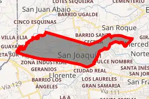
San Joaquín de Flores
San Joaquín is a district of the Flores canton, in the Heredia province of Costa Rica.[1][2]
San Joaquín | |
|---|---|
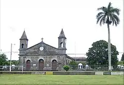 San Joaquín Church | |
San Joaquín district | |
 San Joaquín San Joaquín district location in Costa Rica | |
| Coordinates: 10.0059992°N 84.1538838°W | |
| Country | |
| Province | Heredia |
| Canton | Flores |
| Area | |
| • Total | 2.58 km2 (1.00 sq mi) |
| Elevation | 1,054 m (3,458 ft) |
| Population (2011) | |
| • Total | 7,173 |
| • Density | 2,800/km2 (7,200/sq mi) |
| Time zone | UTC−06:00 |
| Postal code | 40801 |
Toponymy
The town of San Joaquín de Flores is named after Saint Joachim, Mary's father.
Communities and settlements
San Joaquín de Flores District is further divided into smaller units called poblados (or communities) and barrios (or neighborhoods):
- Santa Marta
- Santísima Trinidad
- Santa Cecilia
- Llorente
- Barrantes
- Las Flores
- Los Ángeles
- Los Geranios
- Echeverría
- El Rosario
- Cristo Rey
- Corazón de Jesús
Important buildings
San Joaquín church was built about 1880. Every rock that is part of the church was carried from Cartago by cart, 87 km away along the current national Route 225. Families of San Joaquín donated the statues that today decorate the church gardens. The Spanish painter Jose Claro—who also made paintings for a church in San Antonio de Prado, near Medellín, Colombia—painted the images inside the church. It has also a cavern with a Lourdes Virgin and armchairs made of stone to sit down and view the garden flowers.
Education
The official San Joaquin primary school is Escuela Estados Unidos de America Liceo Regional de Flores and Colegio Tecnico are the two public high schools located in San Joaquin.
Demographics
| Historical population | |||
|---|---|---|---|
| Census | Pop. | %± | |
| 1864 | 870 | — | |
| 1883 | 1,266 | 45.5% | |
| 1892 | 1,641 | 29.6% | |
| 1927 | 1,343 | −18.2% | |
| 1950 | 1,392 | 3.6% | |
| 1963 | 2,222 | 59.6% | |
| 1973 | 3,624 | 63.1% | |
| 1984 | 3,838 | 5.9% | |
| 2000 | 6,346 | 65.3% | |
| 2011 | 7,173 | 13.0% | |
|
Instituto Nacional de Estadística y Censos[4] |
|||
For the 2011 census, San Joaquín had a population of 7,173 inhabitants. [6]
Transportation
Rail transportation
The Interurbano Line operated by Incofer goes through this district.
External sites
References
- "Declara oficial para efectos administrativos, la aprobación de la División Territorial Administrativa de la República N°41548-MGP". Sistema Costarricense de Información Jurídica (in Spanish). 19 March 2019. Retrieved 26 September 2020.
- División Territorial Administrativa de la República de Costa Rica (PDF) (in Spanish). Editorial Digital de la Imprenta Nacional. 8 March 2017. ISBN 978-9977-58-477-5.
- "Área en kilómetros cuadrados, según provincia, cantón y distrito administrativo". Instituto Nacional de Estadística y Censos (in Spanish). Retrieved 26 September 2020.
- "Instituto Nacional de Estadística y Censos" (in Spanish).
- "Sistema de Consulta de a Bases de Datos Estadísticas". Centro Centroamericano de Población (in Spanish).
- "Censo. 2011. Población total por zona y sexo, según provincia, cantón y distrito". Instituto Nacional de Estadística y Censos (in Spanish). Retrieved 26 September 2020.
| Heredia | |
|---|---|
| Barva | |
| Santo Domingo | |
| Santa Bárbara | |
| San Rafael | |
| San Isidro | |
| Belén | |
| Flores | |
| San Pablo | |
| Sarapiquí |
|