San Rafael (canton)
San Rafael is a canton in the Heredia province of Costa Rica.[2][3] The head city is in San Rafael district.
San Rafael | |
|---|---|
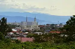 Skyline of San Rafael city, seen from Ángeles district | |
.svg.png.webp) Flag  Seal | |
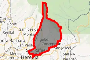
San Rafael canton | |
 San Rafael San Rafael canton location in Costa Rica | |
| Coordinates: 10°02′30″N 84°04′30″W | |
| Country | |
| Province | Heredia |
| Creation | 28 May 1885[1] |
| Head city | San Rafael |
| Districts | |
| Government | |
| • Type | Municipality |
| • Body | Municipalidad de San Rafael |
| Area | |
| • Total | 48.39 km2 (18.68 sq mi) |
| Elevation | 1,343 m (4,406 ft) |
| Population (2011) | |
| • Total | 45,965 |
| • Density | 950/km2 (2,500/sq mi) |
| Time zone | UTC−06:00 |
| Canton code | 405 |
| Website | www |
History
San Rafael was created on 28 May 1885 by decree 10.[1]
Geography
San Rafael has an area of 48.39 km²[4] and a mean elevation of 1,343 metres.[2]
The canton is northeast of the provincial capital city of Heredia, reaching from the suburbs high into the Cordillera Central (Central Mountain Range).
Districts
The canton of San Rafael is subdivided into the following districts:
Demographics
| Historical population | |||
|---|---|---|---|
| Census | Pop. | %± | |
| 1892 | 4,204 | — | |
| 1927 | 4,163 | −1.0% | |
| 1950 | 5,254 | 26.2% | |
| 1963 | 9,069 | 72.6% | |
| 1973 | 16,013 | 76.6% | |
| 1984 | 22,871 | 42.8% | |
| 2000 | 37,293 | 63.1% | |
| 2011 | 45,965 | 23.3% | |
|
Instituto Nacional de Estadística y Censos[5] |
|||
For the 2011 census, San Rafael had a population of 45,965 inhabitants. [7]
Transportation
Road transportation
The canton is covered by the following road routes:
References
- Hernández, Hermógenes (1985). Costa Rica: evolución territorial y principales censos de población 1502 - 1984 (in Spanish) (1 ed.). San José: Editorial Universidad Estatal a Distancia. pp. 164–173. ISBN 9977-64-243-5. Retrieved 5 October 2020.
- "Declara oficial para efectos administrativos, la aprobación de la División Territorial Administrativa de la República N°41548-MGP". Sistema Costarricense de Información Jurídica (in Spanish). 19 March 2019. Retrieved 26 September 2020.
- División Territorial Administrativa de la República de Costa Rica (PDF) (in Spanish). Editorial Digital de la Imprenta Nacional. 8 March 2017. ISBN 978-9977-58-477-5.
- "Área en kilómetros cuadrados, según provincia, cantón y distrito administrativo". Instituto Nacional de Estadística y Censos (in Spanish). Retrieved 26 September 2020.
- "Instituto Nacional de Estadística y Censos" (in Spanish).
- "Sistema de Consulta de a Bases de Datos Estadísticas". Centro Centroamericano de Población (in Spanish).
- "Censo. 2011. Población total por zona y sexo, según provincia, cantón y distrito". Instituto Nacional de Estadística y Censos (in Spanish). Retrieved 26 September 2020.
This article is issued from Wikipedia. The text is licensed under Creative Commons - Attribution - Sharealike. Additional terms may apply for the media files.