San Juan del Cesar
San Juan del Cesar is a municipality and town located in the La Guajira Department, Colombia.
San Juan del Cesar | |
|---|---|
 Flag  Coat of arms | |
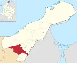 Location of the municipality and town of San Juan del Cesar in La Guajira Department. | |
| Country | Colombia |
| Region | Caribbean |
| Department | La Guajira |
| Foundation | June 24, 1701 by Captain Salvador Felix Arias Pereira |
| Government | |
| • Mayor | Moises Daza Mendoza (C)[1] |
| Area | |
| • Total | 1,415 km2 (546 sq mi) |
| Elevation | 250 m (820 ft) |
| Population (2020 est.[2]) | |
| • Total | 40,069 |
| Time zone | UTC-5 |
| Climate | Aw |
Etymology
San Juan Bautista del Cesar name in English: John the Baptist and Chet-tzar or Sasare indigenous language for calm water, the name of the Cesar River.
History
The region San Juan del Cesar was inhabited by Arhuacos indigenous tribe, led during that time by a Cacique named "Marocazo". It was founded on June 24, 1701 by Captain Salvador Felix Arias Pereira with the name of Villa of San Juan Bautista, over Mount Yiyirigak by the Cesar River. Arias-Pereira was in a mission to "pacify" the indigenous tribes in rebellion; the Tupes, Coyaimas, Conopans and Marocazos.[3]
The Villa of San Juan immediately became a pass for people traveling between Valledupar and the port of Riohacha, back then an important commercial route flowing with cattle and agricultural products. The first church was built by Priest Gonzalo Suárez Oñate.
Geography
The municipality of San Juan del Cesar is located between the mountain ranges of the Sierra Nevada de Santa Marta and the Serranía del Perijá by the Cesar River and close to the Ranchería River. It borders to the north with the municipality of Riohacha and Distracción, to the south with the municipalities of Villanueva, El Molino and the Cesar Department. To the east with the Bolivarian Republic of Venezuela, to the west again with the municipality of Riohacha, Dibulla and Cesar Department covering a total area of 1,415 km². The urban area of San Juan del Cesar covers 10% of this area; 141 km² and the rural area 90%; 1,274 km².
Climate
The average temperature is 27°C year round.
Administrative divisions
Neighborhoods
The municipality seat of San Juan del Cesar had in 2003 some 35 neighborhoods; Villa Corelca, Gran Colombia, Manzanares, El Centro, La Floresta, San Rafael, Regional, La Victoria, Juan Bautista Forero, Loma Fresca, Manzanillo, Paraíso de Betel, La Esperanza, 16 de Julio, Norte Félix Arias, 20 de Julio, Buenos Aires, El Prado, Las Delicias, Alpes, Enrique Brito, El Carmen, San Francisco, Juan Antonio Araujo, Rafael de Armas, Las Tunas I y II, Chiquinquirá, Villa Hermosa, Manuel Antonio Dávila, San Juan Bautista, Chapinero, Los Ángeles and Los Olivos.[3]
Corregimientos
- Cañaverales
- Caracolí
- Corral de Piedras
- El Totumo
- Guayacanal
- La Junta
- La Peña
- Los Haticos
- Los Pondores
- Villa del río
Centros Poblados
- Boca del Monte
- Corralejas
- Curazao
- El Hatico de los Indios
- El Tablazo
- La Peña de los Indios
- Lagunita
- Los Cardones
- El Placer
- Los Pozos
- La Sierrita
- Pondorito
- Potrerito
- Zambrano
Veredas
- Boca del Monte
- Copo de Nieve
- Curazao
- El Caney
- El Capuchino
- El Carmen
- El Limón
- El Machín
- El Pital
- El Placer
- El Playón
- El Voladorcito
- Farias
- La Loma del Potrero
- Los Tamacos
- Los Tunales
- Piloncito
- Sabana Grande
- Sabanas de Joaquina
- San Benito
- Tocapalma
- Torcuatopinto
- Ulago
References
External links
- (in Spanish) San Juan del Cesar official website