San Sebastián (district)
San Sebastián is the eleventh district of the San José canton, in the San José province of Costa Rica.[1][2] An important residential district, San Sebastián is the third most populated and second most densely populated in the canton.
San Sebastián | |
|---|---|
San Sebastián district | |
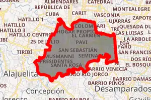
 San Sebastián San Sebastián district location in Costa Rica | |
| Coordinates: 9.9103562°N 84.0822702°W | |
| Country | |
| Province | San José |
| Canton | San José |
| Area | |
| • Total | 4.01 km2 (1.55 sq mi) |
| Elevation | 1,125 m (3,691 ft) |
| Population (2011) | |
| • Total | 40,065 |
| • Density | 10,000/km2 (26,000/sq mi) |
| Time zone | UTC−06:00 |
| Postal code | 10111 |
Geography
San Sebastián has an area of 4.01 km²[3] and an elevation of 1,125 metres.[1] It shares its southern border with San José Province's Alajuelita and Desamparados cantons. The district also limits its counterparts, counterclockwise: Hatillo District (west), Hospital and Catedral districts to the north, and San Francisco de Dos Ríos District to the east.[4]
Demographics
| Historical population | |||
|---|---|---|---|
| Census | Pop. | %± | |
| 1883 | 650 | — | |
| 1892 | 795 | 22.3% | |
| 1927 | 1,401 | 76.2% | |
| 1950 | 5,975 | 326.5% | |
| 1963 | 23,166 | 287.7% | |
| 1973 | 32,019 | 38.2% | |
| 1984 | 35,081 | 9.6% | |
| 2000 | 43,245 | 23.3% | |
| 2011 | 40,065 | −7.4% | |
|
Instituto Nacional de Estadística y Censos[5] |
|||
For the 2011 census, San Sebastián had a population of 40,065 inhabitants. [7]
Locations
San Sebastián District includes the "barrios" (or neighbourhoods) of Bajos Canada, Bengala, Bilbao, Cañada Sur, Carmen, Cascajal, Cerro Azul, Colombari, Colonia Kennedy, Guacamaya, Hogar Propio, Jazmin, Lopez Mateo, Los Geranios, Los Olivos, Luna Park, Mojados, Mojito, Parque de La Paz, Paso Ancho, Pavi, Presidentes, San Gerardo, San Martín, San Sebastián, Santa Rosa, Santo Domingo Sabio, Seminario, Galenos, Umará and Zorobarú.
Transportation
Road transportation
The district is covered by the following road routes:
External links
- Municipalidad de San José. Distrito San Sebastián – Website of San Jose Mayor, includes a map of the district and related info.
References
- "Declara oficial para efectos administrativos, la aprobación de la División Territorial Administrativa de la República N°41548-MGP". Sistema Costarricense de Información Jurídica (in Spanish). 19 March 2019. Retrieved 26 September 2020.
- División Territorial Administrativa de la República de Costa Rica (PDF) (in Spanish). Editorial Digital de la Imprenta Nacional. 8 March 2017. ISBN 978-9977-58-477-5.
- "Área en kilómetros cuadrados, según provincia, cantón y distrito administrativo". Instituto Nacional de Estadística y Censos (in Spanish). Retrieved 26 September 2020.
- Mapa Cantonal del Censo de 1984, published by the National Institute of Statistics and Census(INEC) and updated by the Central American Population Center (CCP)
- "Instituto Nacional de Estadística y Censos" (in Spanish).
- "Sistema de Consulta de a Bases de Datos Estadísticas". Centro Centroamericano de Población (in Spanish).
- "Censo. 2011. Población total por zona y sexo, según provincia, cantón y distrito". Instituto Nacional de Estadística y Censos (in Spanish). Retrieved 26 September 2020.