Escazú (canton)
Escazú is the second canton in the province of San José in Costa Rica.[2][3]
Escazú | |
|---|---|
 Escazú at night. | |
 Flag  Seal | |
Escazú canton | |
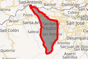
 Escazú Escazú canton location in Costa Rica | |
| Coordinates: 9.9167075°N 84.1532395°W | |
| Country | |
| Province | San José |
| Creation | 7 December 1848[1] |
| Head city | Escazú |
| Districts | Districts
|
| Government | |
| • Type | Municipality |
| • Body | Municipalidad de Escazú |
| Area | |
| • Total | 34.49 km2 (13.32 sq mi) |
| Elevation | 1,129 m (3,704 ft) |
| Population (2011) | |
| • Total | 56,509 |
| • Density | 1,600/km2 (4,200/sq mi) |
| Time zone | UTC−06:00 |
| Canton code | 102 |
| Website | www |
The canton lies west of the San José Canton and its whole territory is part of the Greater Metropolitan Area.
The canton was one of the earliest established in the country, in 7 December 1848.[4] As the metropolitan area has expanded Escazú has become a suburban area on the west side of the national capital city of San José. It is delineated by the Río Tiribí on its northern border. The peak of Cerro Cedral in the Cerros de Escazú marks the southern limit of the canton.
Toponymy
The name "Escazú" derives from the indigenous word "Izt-kat-zu", which means "resting stone". The story tells of Indians traveling from Aserri (south of San Jose) to Pacaca (near Ciudad Colon), who used to stop and rest at this location, which was about halfway between the two villages.
History
Escazú was first mentioned as a canton in a decree dated 7 December 1848.
The first inhabitants were natives from the Guetaras or Huaca tribes. By 1755, villagers were ordered out of Escazú and moved to San José by force. From 1796 to 1799 the church of San Miguel was built with the cooperation of the people that had already re-established at this site. By 1801 the population of Escazú reached 1,325. On May 28, 1920, the government of Costa Rica granted Escazú the status of City, head of the Canton (County) of Escazú.
Popular legend tags Escazú as La Ciudad de las Brujas (the City of the Witches), leading to its municipal seal, a depiction of a witch on a broomstick flying over the surrounding mountains.
Landmarks
Local landmarks in the canton include the Costa Rica Country Club, the Multi Plaza Mall, and more recently, Avenida Escazú. These new complexes hold some of the world's most luxurious brands in Multiplaza Mall. Escazú is also home to several diplomatic missions, including the residence of the Ambassador from the United States.
Demographics
| Historical population | |||
|---|---|---|---|
| Census | Pop. | %± | |
| 1864 | 8,760 | — | |
| 1883 | 5,550 | −36.6% | |
| 1892 | 6,522 | 17.5% | |
| 1927 | 5,113 | −21.6% | |
| 1950 | 7,141 | 39.7% | |
| 1963 | 14,250 | 99.6% | |
| 1973 | 25,026 | 75.6% | |
| 1984 | 33,101 | 32.3% | |
| 2000 | 52,372 | 58.2% | |
| 2011 | 56,509 | 7.9% | |
|
Instituto Nacional de Estadística y Censos[7] |
|||
For the 2011 census, Escazú had a population of 56,509 inhabitants. [9]
The canton's urban areas are home to 79.8% of its population. Children under the age of 10 account for 17.88% of the population, while 6.05% are over 65.
According to a 2012 United Nations Development Programme, Escazú ranks as the 4th highest canton in Costa Rica in so far as human development.[10]
Transportation
Road transportation
The canton is covered by the following road routes:
References
- Hernández, Hermógenes (1985). Costa Rica: evolución territorial y principales censos de población 1502 - 1984 (in Spanish) (1 ed.). San José: Editorial Universidad Estatal a Distancia. pp. 164–173. ISBN 9977-64-243-5. Retrieved October 5, 2020.
- "Declara oficial para efectos administrativos, la aprobación de la División Territorial Administrativa de la República N°41548-MGP". Sistema Costarricense de Información Jurídica (in Spanish). March 19, 2019. Retrieved September 26, 2020.
- División Territorial Administrativa de la República de Costa Rica (PDF) (in Spanish). Editorial Digital de la Imprenta Nacional. March 8, 2017. ISBN 978-9977-58-477-5.
- "Municipalidad de Escazú, Costa Rica – Reseña Histórica". escazu.go.cr. Retrieved December 20, 2015.
- "Área en kilómetros cuadrados, según provincia, cantón y distrito administrativo". Instituto Nacional de Estadística y Censos (in Spanish). Retrieved September 26, 2020.
- "División Territorial Administrativa de Costa Rica" (PDF) (in Spanish). Instituto de Fomento y Asesoria Municipal (IFAM). May 5, 2009. Archived from the original (PDF) on August 2, 2015.
- "Instituto Nacional de Estadística y Censos" (in Spanish).
- "Sistema de Consulta de a Bases de Datos Estadísticas". Centro Centroamericano de Población (in Spanish).
- "Censo. 2011. Población total por zona y sexo, según provincia, cantón y distrito". Instituto Nacional de Estadística y Censos (in Spanish). Retrieved September 26, 2020.
- "Atlas del Desarrollo Humano Cantonal de Costa Rica 2012 | PNUD- UCR". www.pnud.or.cr. Archived from the original on March 5, 2016. Retrieved December 20, 2015.