San Vicente, Texas
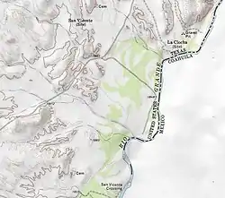
San Vicente was a village located in Brewster County, Texas within the protruding big bend of the Rio Grandé river.[1] The village was geographically 1.5 miles (2.4 km) north of the San Vicente Crossing in present day Big Bend National Park. The uninhabited site provides a panoramic view of the Chisos Mountains and the Sierra San Vicente migrating into Northern Mexico.
San Vicente, Texas | |
|---|---|
Ghost Town | |
 | |
 San Vicente, Texas Location within Texas  San Vicente, Texas San Vicente, Texas (the United States) | |
| Coordinates: 29°09′14″N 103°01′12.5″W | |
| Country | United States |
| State | Texas |
| County | Brewster |
| Elevation | 1,896 ft (578 m) |
| Time zone | UTC-6 (Central (CST)) |
| • Summer (DST) | UTC-5 (CDT) |
| ZIP codes | 79834 |
| Area code | 432 |
| GNIS feature ID | 1367543 |
Presidio of San Vicente
On September 10, 1772, the Spanish Empire issued new regulations for presidios constructed in New Spain along the southern boundaries of the Rio Grandé river basin in the Northern Mexico territories.[2][3] Presidio de San Vicente was established in 1773 offering sanctuary for Spanish Texas pioneers seeking passage through the San Vicente Crossing at the Rio Grandé river.[4][5] The presidio fortification was an adobe and pueblo style structure serving as a garrison while providing a defensive wall against the native plains inhabitants during the Mexican Indian Wars.[6] The Spanish Presidio promoted the development of New Spain in the Chihuahua and Coahuila territories of the Spanish colonies while fortifying the Spanish missions in Texas.[7]
Historical Citations of San Vicente
San Vicente settlement established cemeteries north and south of the village vicinity encompassing 1.6 miles (2.6 km) between the memorial grounds.[8][9] The south funerary plot has a proximity to the San Vicente Crossing on the Rio Grandé river.[10][11]
See also
References
- Kohout, Martin Donell. "San Vicente, TX". Handbook of Texas Online. Texas State Historical Association.
- Chipman, Donald E. "New Regulations For Presidios". Handbook of Texas Online. Texas State Historical Association.
- Faulk, Odie B. "Presidios". Handbook of Texas Online. Texas State Historical Association.
- "Missions, Presidios, and Settlements of Spanish Texas" [El Paso Missions] (PDF). Texas Beyond History. University of Texas at Austin.
- United States Geological Survey. San Vicente, TX quadrangle, San Vicente Crossing (Topographic map). Reston, VA: United States Geological Survey – via TopoQuest.
- "Presidio de San Vicente". Texas Beyond History. University of Texas at Austin.
- "Spanish Frontier 1715-1821" [La Junta de los Rios (The Meeting of the Rivers)]. Texas Beyond History. University of Texas at Austin.
- "North San Vicente Cemetery - Brewster County". Texas Historic Sites Atlas. Texas Historical Commission.
- United States Geological Survey. San Vicente, TX quadrangle, San Vicente (North) (Topographic map). Reston, VA: United States Geological Survey – via TopoQuest.
- "South San Vicente Cemetery - Brewster County". Texas Historic Sites Atlas. Texas Historical Commission.
- United States Geological Survey. San Vicente, TX quadrangle, San Vicente (South) (Topographic map). Reston, VA: United States Geological Survey – via TopoQuest.
External links
- "Big Bend Presidios". Texas Beyond History. University of Texas at Austin.
- Ivey, James E. "Presidios of the Big Bend Area" (PDF). National Park Service. U.S. Department of the Interior.
- "Regulations, San Ildefonso, September 10, 1772" [The Threads of Memory: Spain and the United States]. New Mexico History Museum. New Mexico Department of Cultural Affairs.
- Haskell, Marion L. (January 1, 1918). "Review Of Rubí's Inspection of the Frontier Presidios of New Spain, 1766-1768". Internet Archive. Historical Society of Southern California. JSTOR 41168757.
- "The Gateway Missions" [Attempts at Native Conversions along the Rio Grande]. Texas Beyond History. University of Texas at Austin.
- "The Threads of Memory: Spain and the United States". Threads of Memory Exhibition ~ New Mexico History Museum. New Mexico Department of Cultural Affairs.
Municipalities and communities of Brewster County, Texas, United States | ||
|---|---|---|
| City | 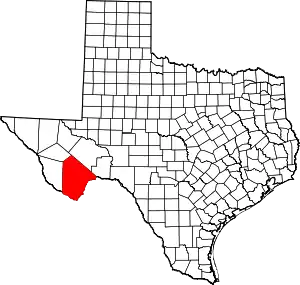 Brewster County map | |
| CDPs | ||
| Other unincorporated communities | ||
| Ghost towns | ||
| Annexed former counties | ||
| ||