Santeny
Santeny is a commune in the southeastern suburbs of Paris, France. It is located 21.8 km (13.5 mi) from the center of Paris.
Santeny | |
|---|---|
.jpg.webp) The town hall of Santeny | |
 Coat of arms | |
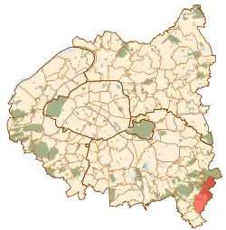 Paris and inner ring departments | |
Location of Santeny 
| |
 Santeny Paris and inner ring departments  Santeny Santeny (Île-de-France (region)) | |
| Coordinates: 48°43′33″N 2°34′20″E | |
| Country | France |
| Region | Île-de-France |
| Department | Val-de-Marne |
| Arrondissement | Créteil |
| Canton | Plateau briard |
| Intercommunality | Grand Paris |
| Government | |
| • Mayor (2020–2026) | Vincent Bedu |
| Area 1 | 9.91 km2 (3.83 sq mi) |
| Population (2017-01-01)[1] | 3,775 |
| • Density | 380/km2 (990/sq mi) |
| Time zone | UTC+01:00 (CET) |
| • Summer (DST) | UTC+02:00 (CEST) |
| INSEE/Postal code | 94070 /94440 |
| Elevation | 60–105 m (197–344 ft) |
| 1 French Land Register data, which excludes lakes, ponds, glaciers > 1 km2 (0.386 sq mi or 247 acres) and river estuaries. | |
Transport
Santeny is served by no station of the Paris Métro, RER, or suburban rail network. The closest station to Santeny is Boissy-Saint-Léger station on Paris RER line A. This station is located in the commune of Boissy-Saint-Léger, 5.7 km (3.5 mi) from the town center of Santeny.
Education
Santeny has one consolidated preschool/nursery (maternelle) and elementary school: Groupe scolaire des 40 Arpents. The commune also has Collège Georges-Brassens, a public junior high school.[2]
Area senior high schools/sixth-form colleges:[2]
- Lycée Guillaume-Budé - Limeil-Brévannes
- Lycée Christophe-Colomb - Sucy-en-Brie
- Lycée des métiers hôteliers Montaleau - Sucy-en-Brie
References
- "Populations légales 2017". INSEE. Retrieved 6 January 2020.
- "Enseignement." Santeny. Retrieved on September 11, 2016.
External links
| Wikimedia Commons has media related to Santeny. |
- Home page (in French)
| Authority control |
|---|
This article is issued from Wikipedia. The text is licensed under Creative Commons - Attribution - Sharealike. Additional terms may apply for the media files.
