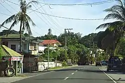
Santiago, Ilocos Sur
Santiago, officially the Municipality of Santiago (Ilocano: Ili ti Santiago; Filipino: Bayan ng Santiago), is a 4th class municipality in the province of Ilocos Sur, Philippines. According to the 2015 census, it has a population of 18,759 people. [3]
Santiago | |
|---|---|
| Municipality of Santiago | |
 | |
 Seal | |
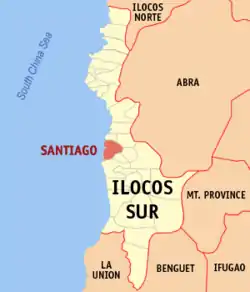 Map of Ilocos Sur with Santiago highlighted | |
OpenStreetMap 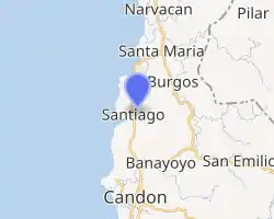
| |
.svg.png.webp) Santiago Location within the Philippines | |
| Coordinates: 17°18′N 120°27′E | |
| Country | |
| Region | Ilocos Region (Region I) |
| Province | Ilocos Sur |
| District | 2nd District |
| Barangays | 24 (see Barangays) |
| Government | |
| • Type | Sangguniang Bayan |
| • Mayor | Josefino E. Miranda |
| • Vice Mayor | Adrien Lawrence S. Miranda |
| • Representative | Kristine Singson-Meehan |
| • Electorate | 12,705 voters (2019) |
| Area | |
| • Total | 46.36 km2 (17.90 sq mi) |
| Elevation | 54 m (177 ft) |
| Population | |
| • Total | 18,759 |
| • Density | 400/km2 (1,000/sq mi) |
| • Households | 4,295 |
| Economy | |
| • Income class | 4th municipal income class |
| • Poverty incidence | 13.02% (2015)[4] |
| • Revenue | ₱290,583,630.45 (2016) |
| Time zone | UTC+8 (PST) |
| ZIP code | 2707 |
| PSGC | |
| IDD : area code | +63 (0)77 |
| Climate type | tropical monsoon climate |
| Native languages | Ilocano Tagalog |
Santiago Cove is dubbed as the "Boracay of Ilocos Sur" because of its white sands.[5]
Santiago is the headquarters of the Ilocos Sur Electric Cooperative (ISECO), which distributes electricity to the entire province.
History
As soon the Spaniards colonized the Philippines, Spain sent missionaries to spread Christianity, on of heir purposes in their colonization. Christianity was then spread throughout the Philipiines. The Spaniards organized group’s called pueblos and divided these into sitios for easier proselytization and evangelization. From then on, the pueblo built tribunals for the Spanish government and churches and converts for the missionaries to live. Because the Muslim were the champions of Islamic religion and because they considered war as an occupation and piracy as a hobby, they raided Christian pueblos along China Seacoast of the Philippines. In June 1578, Span started the Moro Wars in Jolo. This aggressive act marked the beginning of a long, bloody conflict between Spaniards and the moros. In 1602, Spain sent punitive expeditions to Zamboanga, Cotobato and other places to curb the rising tide of Moro depredations. In were built along the seacoasts from Mindanao to Luzon. Armed galleys and frigates patrolled the sea-lanes. The Marcos stopped the raids for a while. The Moros renewed their piratical forays. In 1717, they swept the Visayan Islands and attacked Appari and Northern Luzon. According to an old resident, Moro pirates entered the pueblo known today as Santiago in their return to Jolo. Guards in the watchtowers sounded their trumpets warning all the people of the pueblo of the arrival of the pirates. The church bells also rang alarming the people that pirates are fast approaching the shore. The people rushed and got their available arms like bolos, bows and arrows and fought the pirates boldly. Sporadic battles ensued. These lasted for few hours. As the battle went on, the missionaries stations=greater which they bought with them from Spain and held it high facing the seashore praying fervently the rosary with few people, for the safety and victory of his Christian followers, The Moros ran away and fled southward in their kumpits leaving behind their dead. After the battle, a solemn mass was held in the church. The missionary told the people that due the great intercession and miraculous protection of the image of St.James the Greater from the Moro Pirates, this pueblo was saved and in his honor, this town was named SANTIAGO ( Spanish for Saint James).
Geography
Santiago is 358 kilometres (222 mi) from Metro Manila and 49 kilometres (30 mi) from Vigan City, the provincial capital.
Barangays
Santiago is politically subdivided into 24 barangays. [2]
- Al-aludig
- Ambucao
- San Jose (Baraoas)
- Baybayabas
- Bigbiga
- Bulbulala
- Busel-busel
- Butol
- Caburao
- Dan-ar
- Gabao
- Guinabang
- Imus
- Lang-ayan
- Mambug
- Nalasin
- Olo-olo Norte
- Olo-olo Sur
- Poblacion Norte
- Poblacion Sur
- Sabangan
- Salincub
- San Roque
- Ubbog
Climate
| Climate data for Santiago, Ilocos Sur | |||||||||||||
|---|---|---|---|---|---|---|---|---|---|---|---|---|---|
| Month | Jan | Feb | Mar | Apr | May | Jun | Jul | Aug | Sep | Oct | Nov | Dec | Year |
| Average high °C (°F) | 30 (86) |
31 (88) |
33 (91) |
34 (93) |
32 (90) |
31 (88) |
30 (86) |
30 (86) |
30 (86) |
31 (88) |
31 (88) |
30 (86) |
31 (88) |
| Average low °C (°F) | 19 (66) |
20 (68) |
21 (70) |
23 (73) |
25 (77) |
25 (77) |
25 (77) |
24 (75) |
24 (75) |
22 (72) |
21 (70) |
19 (66) |
22 (72) |
| Average precipitation mm (inches) | 10 (0.4) |
10 (0.4) |
14 (0.6) |
23 (0.9) |
80 (3.1) |
103 (4.1) |
121 (4.8) |
111 (4.4) |
119 (4.7) |
144 (5.7) |
39 (1.5) |
15 (0.6) |
789 (31.2) |
| Average rainy days | 5.2 | 3.9 | 6.2 | 9.1 | 18.5 | 21.4 | 22.9 | 19.8 | 19.8 | 16.2 | 10.5 | 6.1 | 159.6 |
| Source: Meteoblue (modeled/calculated data, not measured locally) [6] | |||||||||||||
Demographics
|
| ||||||||||||||||||||||||||||||||||||||||||||||||
| Source: Philippine Statistics Authority [3] [7] [8][9] | |||||||||||||||||||||||||||||||||||||||||||||||||
In the 2015 census, the population of Santiago, Ilocos Sur, was 18,759 people, [3] with a density of 400 inhabitants per square kilometre or 1,000 inhabitants per square mile.
Gallery
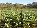 A field of tobacco growing in Baybayabas
 A man fishing just offshore near Gabao Beach.
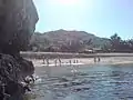 A beach in Ambucao
References
- Municipality of Santiago | (DILG)
- "Province: Ilocos Sur". PSGC Interactive. Quezon City, Philippines: Philippine Statistics Authority. Retrieved 12 November 2016.
- Census of Population (2015). "Region I (Ilocos Region)". Total Population by Province, City, Municipality and Barangay. PSA. Retrieved 20 June 2016.
- "PSA releases the 2015 Municipal and City Level Poverty Estimates". Quezon City, Philippines. Retrieved 1 January 2020.
- "Sunrise at Santiago". Retrieved 14 January 2008.
- "Santiago: Average Temperatures and Rainfall". Meteoblue. Retrieved 14 May 2020.
- Census of Population and Housing (2010). "Region I (Ilocos Region)". Total Population by Province, City, Municipality and Barangay. NSO. Retrieved 29 June 2016.
- Censuses of Population (1903–2007). "Region I (Ilocos Region)". Table 1. Population Enumerated in Various Censuses by Province/Highly Urbanized City: 1903 to 2007. NSO.
- "Province of Ilocos Sur". Municipality Population Data. Local Water Utilities Administration Research Division. Retrieved 17 December 2016.
External links
| Wikimedia Commons has media related to Santiago, Ilocos Sur. |
- Pasyalang Ilocos Sur
- Philippine Standard Geographic Code
- Philippine Census Information
- Local Governance Performance Management System
Places adjacent to Santiago, Ilocos Sur | ||||||||||
|---|---|---|---|---|---|---|---|---|---|---|
| ||||||||||