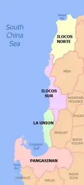
Ilocos Region
Ilocos Region (Ilocano: Rehion/Deppaar ti Ilocos; Pangasinan: Sagor na Baybay na Luzon; Tagalog: Rehiyon ng Ilocos) is an administrative region of the Philippines, designated as Region I, occupying the northwestern section of Luzon. It is bordered by the Cordillera Administrative Region to the east, the Cagayan Valley to the northeast and southeast, and the Central Luzon to the south. To the west lies the South China Sea.
Ilocos Region
Region I | |
|---|---|
.jpg.webp) 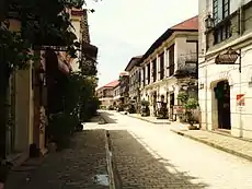  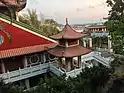 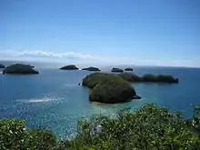 | |
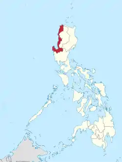 Location in the Philippines | |
| Coordinates: 16°37′N 120°19′E | |
| Country | |
| Island group | Luzon |
| Regional center | San Fernando (La Union) |
| Area | |
| • Total | 13,012.60 km2 (5,024.19 sq mi) |
| Population | |
| • Total | 5,026,128 |
| • Estimate (2020) | 5,220,807[2] |
| • Density | 390/km2 (1,000/sq mi) |
| Human Development Index | |
| • HDI (2018) | 0.719[3] high · 5th |
| Time zone | UTC+8 (PST) |
| ISO 3166 code | PH-01 |
| Provinces | |
| Independent Cities | |
| Component Cities | |
| Municipalities | 116 |
| Barangays | 3,265 |
| Cong. districts | 12 |
| Languages | |
The region comprises four provinces: Ilocos Norte, Ilocos Sur, La Union and Pangasinan. Its regional center is San Fernando, La Union. The 2000 Census reported that the major languages spoken in the region are Ilocano at 66.36% of the total population at that time, Pangasinan with 27.05%, and Tagalog with 3.21%.[4]
History
The region was first inhabited by the aboriginal Negritos, before they were pushed by successive waves of Austronesian immigrants that penetrated the narrow coast. Tingguians in the interior, Ilocanos in the north, Pangasinans in the south, and Zambals in the southwesternmost areas settled the region. Before the administration of Ferdinand Marcos, Pangasinan was not a part of the region.[5]
The Spanish arrived in the 16th century and established Christian missions and governmental institutions to control the native population and convert them to Catholicism. Present-day Vigan in Ilocos Sur province became the diocesan seat of Nueva Segovia. Ilocanos in the northern parts were less easily swayed, however, and remained an area filled with deep resentments against Spain. These resentments surfaced at various points in the Ilocos provinces' history as insurrections, most notably that of Andres Malong and Palaris of Pangasinan, Diego Silang and his wife Gabriela Silang in 1764, and the Basi Revolt in the 19th century. However, it was the Pangasinans in the south who were the last to stand against the Spaniards.[6]
In 1901, the region came under American colonial rule, and in 1941, under Japanese occupation.
During 1945, the combined American and the Philippine Commonwealth troops including with the Ilocano and Pangasinan guerillas liberated the Ilocos Region from Japanese forces during the Second World War.
Several modern presidents of the Republic of the Philippines hailed from the Region: Elpidio Quirino, Ferdinand Marcos, and Fidel V. Ramos. The province of Pangasinan was transferred by Ferdinand Marcos from Region III into Region I in 1973 and afterwards imposed a migration policy for Ilokanos into Pangasinan, to the moderate detriment of the native Pangasinenses. He also included Abra, Mountain Province, and Benguet in the Ilocos region in a bid to expand Ilokano influence amongst the ethnic peoples of the Cordilleras.[7]
When the Cordillera Administrative Region was established under Corazon Aquino, the indigenous provinces of Abra, Mountain Province, and Benguet were transferred into the newly formed region.
Geography
The Ilocos Region occupies the narrow plain between the Cordillera Central mountain range and the South China Sea, and the northern portion of the Central Luzon plain, to the north-east of the Zambales Mountains.
Lingayen Gulf is the most notable body of water in the region and it contains several islands, including the Hundred Islands National Park. To the north of the region is Luzon Strait.
The Agno River runs through Pangasinan from Benguet, flowing into a broad delta at the vicinities of Lingayen and Dagupan before emptying into the Lingayen Gulf.
Administrative divisions
The Ilocos Region comprises 4 provinces, 1 independent component city, 8 component cities, 116 municipalities, and 3,265 barangays.[8]
Provinces
| Province | Capital | Population (2020 Estimate)[9] | Area[10] | Density | Cities | Muni. | Barangay | |||||
|---|---|---|---|---|---|---|---|---|---|---|---|---|
| km2 | sq mi | /km2 | /sq mi | |||||||||
| Ilocos Norte | Laoag | 11.7% | 613,422 | 3,467.89 | 1,338.96 | 180 | 470 | 2 | 21 | 557 | ||
| Ilocos Sur | Vigan | 13.7% | 715,811 | 2,596.00 | 1,002.32 | 280 | 730 | 2 | 32 | 768 | ||
| La Union | San Fernando | 16.5% | 828,193 | 1,497.70 | 578.27 | 550 | 1,400 | 1 | 19 | 576 | ||
| Pangasinan | Lingayen | 59.6% | 3,113,361 | 5,451.01 | 2,104.65 | 570 | 1,500 | 4 | 44 | 1,364 | ||
| Total | 5,026,128 | 13,012.60 | 5,024.19 | 390 | 1,000 | 9 | 116 | 3,265 | ||||
|
• Figures for Pangasinan include the independent component city of Dagupan. | ||||||||||||
Cities and Municipalities
- † Regional center
| City/Municipality | Population 2005 | Area[11] | Density | Class | Income class | Province | ||
|---|---|---|---|---|---|---|---|---|
| Adams | 1,792 | 159.31 | 61.51 | 11 | 28 | Municipality | 5th | Ilocos Norte |
| Agno | 28,052 | 169.75 | 65.54 | 170 | 440 | Municipality | 3rd | Pangasinan |
| Agoo | 63,692 | 52.84 | 20.40 | 1,200 | 3,100 | Municipality | 1st | La Union |
| Aguilar | 41,463 | 195.07 | 75.32 | 210 | 540 | Municipality | 3rd | Pangasinan |
| Alaminos City | 89,708 | 164.26 | 63.42 | 550 | 1,400 | Component City | 4th | Pangasinan |
| Alcala | 43,402 | 45.71 | 17.65 | 950 | 2,500 | Municipality | 3rd | Pangasinan |
| Alilem | 6,695 | 119.33 | 46.07 | 56 | 150 | Municipality | 4th | Ilocos Sur |
| Anda | 39,504 | 74.55 | 28.78 | 530 | 1,400 | Municipality | 3rd | Pangasinan |
| Aringay | 47,458 | 84.54 | 32.64 | 560 | 1,500 | Municipality | 2nd | La Union |
| Asingan | 57,355 | 66.64 | 25.73 | 860 | 2,200 | Municipality | 2nd | Pangasinan |
| Bacarra | 32,215 | 65.32 | 25.22 | 490 | 1,300 | Municipality | 3rd | Ilocos Norte |
| Bacnotan | 42,078 | 76.60 | 29.58 | 550 | 1,400 | Municipality | 1st | La Union |
| Badoc | 31,616 | 76.68 | 29.61 | 410 | 1,100 | Municipality | 2nd | Ilocos Norte |
| Bagulin | 13,456 | 107.33 | 41.44 | 130 | 340 | Municipality | 5th | La Union |
| Balaoan | 39,188 | 68.70 | 26.53 | 570 | 1,500 | Municipality | 1st | La Union |
| Balungao | 31,106 | 73.25 | 28.28 | 420 | 1,100 | Municipality | 4th | Pangasinan |
| Banayoyo | 7,748 | 24.63 | 9.51 | 310 | 800 | Municipality | 4th | Ilocos Sur |
| Bangar | 35,947 | 37.36 | 14.42 | 960 | 2,500 | Municipality | 3rd | La Union |
| Bangui | 14,672 | 112.98 | 43.62 | 130 | 340 | Municipality | 4th | Ilocos Norte |
| Bani | 50,306 | 179.65 | 69.36 | 280 | 730 | Municipality | 2nd | Pangasinan |
| Banna | 19,438 | 92.73 | 35.80 | 210 | 540 | Municipality | 4th | Ilocos Norte |
| Bantay | 35,731 | 76.60 | 29.58 | 470 | 1,200 | Municipality | 1st | Ilocos Sur |
| Basista | 32,959 | 24.00 | 9.27 | 1,400 | 3,600 | Municipality | 4th | Pangasinan |
| Batac City | 55,201 | 161.06 | 62.19 | 340 | 880 | Component City | 5th | Ilocos Norte |
| Bauang | 75,032 | 73.15 | 28.24 | 1,000 | 2,600 | Municipality | 1st | La Union |
| Bautista | 32,307 | 46.33 | 17.89 | 700 | 1,800 | Municipality | 4th | Pangasinan |
| Bayambang | 118,205 | 143.94 | 55.58 | 820 | 2,100 | Municipality | 1st | Pangasinan |
| Binalonan | 54,555 | 47.57 | 18.37 | 110 | 280 | Municipality | 1st | Pangasinan |
| Binmaley | 83,052 | 118.50 | 45.75 | 700 | 1,800 | Municipality | 1st | Pangasinan |
| Bolinao | 82,084 | 197.22 | 76.15 | 420 | 1,100 | Municipality | 1st | Pangasinan |
| Bugallon | 67,348 | 189.64 | 73.22 | 360 | 930 | Municipality | 2nd | Pangasinan |
| Burgos | 9,777 | 128.90 | 49.77 | 76 | 200 | Municipality | 5th | Ilocos Norte |
| Burgos | 12,224 | 44.38 | 17.14 | 280 | 730 | Municipality | 4th | Ilocos Sur |
| Burgos | 8,067 | 70.80 | 27.34 | 110 | 280 | Municipality | 5th | La Union |
| Burgos | 21,637 | 131.32 | 50.70 | 160 | 410 | Municipality | 4th | Pangasinan |
| Caba | 22,039 | 46.31 | 17.88 | 480 | 1,200 | Municipality | 4th | La Union |
| Cabugao | 37,501 | 95.56 | 36.90 | 390 | 1,000 | Municipality | 1st | Ilocos Sur |
| Calasiao | 95,154 | 48.36 | 18.67 | 2,000 | 5,200 | Municipality | 1st | Pangasinan |
| Candon City | 60,623 | 103.28 | 39.88 | 590 | 1,500 | Component City | 4th | Ilocos Sur |
| Caoayan | 19,861 | 17.42 | 6.73 | 1,100 | 2,800 | Municipality | 4th | Ilocos Sur |
| Carasi | 1,567 | 82.97 | 32.03 | 19 | 49 | Municipality | 5th | Ilocos Norte |
| Cervantes | 17,211 | 234.70 | 90.62 | 73 | 190 | Municipality | 4th | Ilocos Sur |
| Currimao | 12,184 | 34.08 | 13.16 | 360 | 930 | Municipality | 4th | Ilocos Norte |
| Dagupan City | 171,271 | 44.47 | 17.17 | 3,900 | 10,000 | Independent Component City | 1st | Pangasinan |
| Dasol | 29,110 | 166.60 | 64.32 | 170 | 440 | Municipality | 3rd | Pangasinan |
| Dingras | 38,562 | 96.00 | 37.07 | 400 | 1,000 | Municipality | 2nd | Ilocos Norte |
| Dumalneg | 2,947 | 88.48 | 34.16 | 33 | 85 | Municipality | 5th | Ilocos Norte |
| Galimuyod | 10,748 | 34.40 | 13.28 | 310 | 800 | Municipality | 4th | Ilocos Sur |
| Gregorio del Pilar | 4,875 | 41.66 | 16.09 | 120 | 310 | Municipality | 5th | Ilocos Sur |
| Infanta | 24,584 | 254.29 | 98.18 | 97 | 250 | Municipality | 3rd | Pangasinan |
| Labrador | 23,201 | 90.99 | 35.13 | 250 | 650 | Municipality | 4th | Pangasinan |
| Laoac | 31,497 | 40.50 | 15.64 | 780 | 2,000 | Municipality | 4th | Pangasinan |
| Laoag City | 111,125 | 116.08 | 44.82 | 960 | 2,500 | Component City | 3rd | Ilocos Norte |
| Lidlidda | 4,647 | 33.84 | 13.07 | 140 | 360 | Municipality | 5th | Ilocos Sur |
| Lingayen | 103,278 | 62.76 | 24.23 | 1,600 | 4,100 | Municipality | 1st | Pangasinan |
| Luna | 35,802 | 42.90 | 16.56 | 830 | 2,100 | Municipality | 3rd | La Union |
| Mabini | 24,765 | 291.01 | 112.36 | 85 | 220 | Municipality | 3rd | Pangasinan |
| Magsingal | 30,792 | 84.98 | 32.81 | 360 | 930 | Municipality | 3rd | Ilocos Sur |
| Malasiqui | 130,275 | 131.37 | 50.72 | 990 | 2,600 | Municipality | 1st | Pangasinan |
| Manaoag | 69,497 | 55.95 | 21.60 | 1,200 | 3,100 | Municipality | 1st | Pangasinan |
| Mangaldan | 106,331 | 48.47 | 18.71 | 2,200 | 5,700 | Municipality | 1st | Pangasinan |
| Mangatarem | 73,241 | 317.50 | 122.59 | 230 | 600 | Municipality | 1st | Pangasinan |
| Mapandan | 37,059 | 30.00 | 11.58 | 1,200 | 3,100 | Municipality | 3rd | Pangasinan |
| Marcos | 17,777 | 72.77 | 28.10 | 240 | 620 | Municipality | 4th | Ilocos Norte |
| Nagbukel | 5,259 | 43.12 | 16.65 | 120 | 310 | Municipality | 5th | Ilocos Sur |
| Naguilian | 54,221 | 104.60 | 40.39 | 520 | 1,300 | Municipality | 1st | La Union |
| Narvacan | 44,006 | 122.21 | 47.19 | 360 | 930 | Municipality | 2nd | Ilocos Sur |
| Natividad | 24,299 | 134.36 | 51.88 | 180 | 470 | Municipality | 4th | Pangasinan |
| Nueva Era | 9,506 | 515.02 | 198.85 | 18 | 47 | Municipality | 3rd | Ilocos Norte |
| Pagudpud | 23,770 | 194.90 | 75.25 | 120 | 310 | Municipality | 4th | Ilocos Norte |
| Paoay | 24,866 | 76.24 | 29.44 | 330 | 850 | Municipality | 4th | Ilocos Norte |
| Pasuquin | 28,980 | 210.54 | 81.29 | 140 | 360 | Municipality | 3rd | Ilocos Norte |
| Piddig | 21,497 | 216.20 | 83.48 | 99 | 260 | Municipality | 3rd | Ilocos Norte |
| Pinili | 17,300 | 89.48 | 34.55 | 190 | 490 | Municipality | 4th | Ilocos Norte |
| Pozorrubio | 69,555 | 134.60 | 51.97 | 520 | 1,300 | Municipality | 1st | Pangasinan |
| Pugo | 19,690 | 62.84 | 24.26 | 310 | 800 | Municipality | 5th | La Union |
| Quirino | 8,573 | 240.10 | 92.70 | 36 | 93 | Municipality | 4th | Ilocos Sur |
| Rosales | 63,081 | 66.39 | 25.63 | 950 | 2,500 | Municipality | 1st | Pangasinan |
| Rosario | 55,458 | 73.98 | 28.56 | 750 | 1,900 | Municipality | 1st | La Union |
| Salcedo | 11,288 | 103.44 | 39.94 | 110 | 280 | Municipality | 4th | Ilocos Sur |
| San Carlos City | 188,571 | 169.03 | 65.26 | 1,100 | 2,800 | Component City | 3rd | Pangasinan |
| San Emilio | 7,407 | 141.44 | 54.61 | 52 | 130 | Municipality | 4th | Ilocos Sur |
| San Esteban | 8,349 | 19.62 | 7.58 | 430 | 1,100 | Municipality | 5th | Ilocos Sur |
| San Fabian | 83,025 | 81.28 | 31.38 | 1,000 | 2,600 | Municipality | 1st | Pangasinan |
| † San Fernando City | 121,812 | 102.72 | 39.66 | 1,200 | 3,100 | Component City | 3rd | La Union |
| San Gabriel | 18,172 | 129.87 | 50.14 | 140 | 360 | Municipality | 4th | La Union |
| San Ildefonso | 7,787 | 11.35 | 4.38 | 690 | 1,800 | Municipality | 5th | Ilocos Sur |
| San Jacinto | 40,848 | 44.18 | 17.06 | 920 | 2,400 | Municipality | 3rd | Pangasinan |
| San Juan | 26,411 | 64.37 | 24.85 | 410 | 1,100 | Municipality | 3rd | Ilocos Sur |
| San Juan | 37,188 | 57.12 | 22.05 | 650 | 1,700 | Municipality | 2nd | La Union |
| San Manuel | 52,939 | 129.18 | 49.88 | 410 | 1,100 | Municipality | 1st | Pangasinan |
| San Nicolas | 36,736 | 40.18 | 15.51 | 910 | 2,400 | Municipality | 2nd | Ilocos Norte |
| San Nicolas | 35,574 | 210.20 | 81.16 | 170 | 440 | Municipality | 1st | Pangasinan |
| San Quintin | 32,945 | 115.90 | 44.75 | 280 | 730 | Municipality | 3rd | Pangasinan |
| San Vicente | 12,758 | 12.60 | 4.86 | 1,000 | 2,600 | Municipality | 5th | Ilocos Sur |
| Santa | 15,340 | 109.10 | 42.12 | 140 | 360 | Municipality | 4th | Ilocos Sur |
| Santa Barbara | 82,012 | 61.37 | 23.70 | 1,300 | 3,400 | Municipality | 1st | Pangasinan |
| Santa Catalina | 13,945 | 9.68 | 3.74 | 1,400 | 3,600 | Municipality | 5th | Ilocos Sur |
| Santa Cruz | 39,868 | 88.78 | 34.28 | 450 | 1,200 | Municipality | 1st | Ilocos Sur |
| Santa Lucia | 25,402 | 49.72 | 19.20 | 510 | 1,300 | Municipality | 3rd | Ilocos Sur |
| Santa Maria | 30,321 | 63.31 | 24.44 | 480 | 1,200 | Municipality | 3rd | Ilocos Sur |
| Santa Maria | 33,038 | 69.50 | 26.83 | 480 | 1,200 | Municipality | 4th | Pangasinan |
| Santiago | 18,759 | 46.36 | 17.90 | 400 | 1,000 | Municipality | 4th | Ilocos Sur |
| Santo Domingo | 27,975 | 55.49 | 21.42 | 500 | 1,300 | Municipality | 3rd | Ilocos Sur |
| Santo Tomas | 39,092 | 64.00 | 24.71 | 610 | 1,600 | Municipality | 4th | La Union |
| Santo Tomas | 15,022 | 12.99 | 5.02 | 1,200 | 3,100 | Municipality | 5th | Pangasinan |
| Santol | 12,476 | 93.70 | 36.18 | 130 | 340 | Municipality | 4th | La Union |
| Sarrat | 25,212 | 57.39 | 22.16 | 440 | 1,100 | Municipality | 1st | Ilocos Norte |
| Sigay | 2,737 | 81.55 | 31.49 | 34 | 88 | Municipality | 5th | Ilocos Sur |
| Sinait | 25,640 | 65.56 | 25.31 | 390 | 1,000 | Municipality | 3rd | Ilocos Sur |
| Sison | 47,518 | 81.88 | 31.61 | 580 | 1,500 | Municipality | 3rd | Pangasinan |
| Solsona | 24,121 | 166.23 | 64.18 | 150 | 390 | Municipality | 3rd | Ilocos Norte |
| Sual | 34,149 | 130.16 | 50.26 | 260 | 670 | Municipality | 1st | Pangasinan |
| Sudipen | 17,056 | 97.59 | 37.68 | 170 | 440 | Municipality | 4th | La Union |
| Sugpon | 4,585 | 57.11 | 22.05 | 80 | 210 | Municipality | 5th | Ilocos Sur |
| Suyo | 11,446 | 124.00 | 47.88 | 92 | 240 | Municipality | 4th | Ilocos Sur |
| Tagudin | 39,277 | 151.19 | 58.37 | 260 | 670 | Municipality | 2nd | Ilocos Sur |
| Tayug | 43,149 | 51.24 | 19.78 | 840 | 2,200 | Municipality | 3rd | Pangasinan |
| Tubao | 28,729 | 50.75 | 19.59 | 570 | 1,500 | Municipality | 4th | La Union |
| Umingan | 73,252 | 258.43 | 99.78 | 280 | 730 | Municipality | 1st | Pangasinan |
| Urbiztondo | 50,170 | 81.80 | 31.58 | 610 | 1,600 | Municipality | 3rd | Pangasinan |
| Urdaneta City | 132,940 | 100.26 | 38.71 | 1,300 | 3,400 | Component City | 2nd | Pangasinan |
| Vigan City | 53,879 | 25.12 | 9.70 | 2,100 | 5,400 | Component City | 4th | Ilocos Sur |
| Villasis | 62,333 | 75.83 | 29.28 | 820 | 2,100 | Municipality | 1st | Pangasinan |
| Vintar | 32,220 | 614.35 | 237.20 | 52 | 130 | Municipality | 5th | Ilocos Norte |
Economy
Although the economy in the southern portion of the region, especially Pangasinan, is anchored on agro-industrial and service industry, the economy in the northern portion of the region is anchored in the agricultural sector. The economy in Pangasinan is driven by agro-industrial businesses , such as milkfish (bangus) cultivation and processing, livestock raising, fish paste processing (bagoong), and others. Income in the Ilocos provinces or northern portion mostly come from cultivating rice, tobacco, corn, sugarcane, and fruits; raising livestock such as pigs, chicken, goats, and carabaos (water buffalos).
The distribution of the economic activity in the region may be seen from the collection of tax revenue of the national government. The bulk of the collections come from Pangasinan, which posted 61% of the total.[19]
The service and light manufacturing industries are concentrated in the cities. Dagupan is mostly driven by its local entrepreneurs, which have started to expand its network up to the national level. San Fernando in La Union also has an international shipping port and the upgraded and soon to be developed San Fernando International Airport. While Laoag in Ilocos Norte has an international airport.
The tourism industry, driven by local airlines and land transportation firms in the area like Farinas Transit Company and Partas, focuses on the coastal beaches and on eco-tourism. There are fine sands stretching along Bauang, La Union and the rest of the region.
The region is also rich in crafts, with renowned blanket-weaving and pottery. The Ilocanos' burnay pottery is well known for its dark colored clay.
Demographics
|
| ||||||||||||||||||||||||||||||||||||||||||||||||
| Source: Philippine Statistics Authority[20] | |||||||||||||||||||||||||||||||||||||||||||||||||
The Ilocos provinces are the historical homeland of the Ilocanos. In the 2000 Census, the Ilocanos comprised 66% of the region, Pangasinan people 27%, and the Tagalogs 3%.[4]
Pangasinan is the historical homeland of the Pangasinans. The population of Pangasinan comprises approximately 60% of the total population of the region. The Ilocanos started migrating to Pangasinan in the 19th century.[21] Pangasinan was formerly a province of Region III (Central Luzon) before President Marcos signed Presidential Decree No. 1, 1972, incorporating it into Region I. Minority groups include the Tingguian and Isneg communities that inhabit the foothills of the Cordillera mountains.
The population is predominantly Roman Catholic with strong adherents of Protestantism such as the Aglipayan denomination further north of the country. There are also adherents to other religions, such as Iglesia ni Cristo, Mormons, and the like. There is also an undercurrent of traditional animistic beliefs especially in rural areas. The small mercantile Chinese and Indian communities are primarily Buddhists, Taoists, and Hindus.
Notable people
- José Burgos, one of the Gomburza martyrs during the Spanish Occupation
- Ferdinand Marcos, tenth President of the Philippines
- Elpidio Quirino, sixth President of the Philippines
- Fidel V. Ramos, twelfth President of the Philippines
- Artemio Ricarte, Filipino general during the Philippine Revolution and the Philippine–American War
- Diego Silang, male revolutionary leader during the Spanish Occupation
- Gabriela Silang, female revolutionary leader during the Spanish Occupation
- Manuel Arguilla, writer, patriot, and martyr during the Japanese occupation
- Victorio Edades, Father of Modern Philippine Painting. A National Artist awardee for Visual Arts (Painting) He hailed from Dagupan City
- Salvador Bernal, his output included over 300 productions in art, film and music, and earned him the award of National Artist for Theater and Design in 2003
- Orlando Quevedo, Cardinal and Third Archbishop of the Archdiocese of Cotabato. First Cardinal from Mindanao.
- Gregorio Aglipay, Founder of the Aglipayan Church, He is from Batac, Ilocos Norte
- Juan Luna , Famous Filipino Painter of the ' Spoliarium from Badoc, Ilocos Norte
- Antonio Luna, Army General, who fought in the Philippine American War, He is from Badoc, Ilocos Norte.
- Gloria Diaz , Philippines- 1st Miss Universe from Asingan, La Union
- Teofilo Yldefonso, The 1st Filipino and Southeast Asian to win an Olympic medal and the only Filipino to win multiple medals. He is from Piddig, Ilocos Norte.
References
- Census of Population (2015). "Region I (Ilocos Region)". Total Population by Province, City, Municipality and Barangay. PSA. Retrieved June 20, 2016.
- "POPULATION PROJECTIONS BY REGION, PROVINCE, CITIES AND MUNICIPALITIES, 2020-2025". www.doh.gov.ph. Department of Health. August 27, 2020. Retrieved October 16, 2020.
- "Sub-national HDI – Area Database – Global Data Lab". hdi.globaldatalab.org. Retrieved March 13, 2020.
- "Ilocos Region: To Reach Five Millionth Mark in Nine Years (Results from the 2000 Census of Population and Housing, NSO); Table 8. Language/Dialect Generally Spoken in the Households: Ilocos Region, 2000". Philippine Statistics Authority. January 31, 2003. Archived from the original on April 28, 2003. Retrieved March 29, 2016.
- "Presidential Decree No. 1, s. 1972". September 24, 1972. Retrieved May 27, 2019.
- Culture and History by Nick Joaquin
- "Presidential Decree No. 224, s. 1973". June 22, 1973. Retrieved November 5, 2016.
- "List of Regions". National Statistical Coordination Board. Archived from the original on October 13, 2008. Retrieved January 9, 2011.
- "POPULATION PROJECTIONS BY REGION, PROVINCE, CITIES AND MUNICIPALITIES, 2020-2025". www.doh.gov.ph. Department of Health. August 27, 2020. Retrieved October 16, 2020.
- "PSGC Interactive; List of Provinces". Philippine Statistics Authority. Archived from the original on January 11, 2013. Retrieved March 30, 2016.
- "PSGC Interactive; List of Cities". Philippine Statistics Authority. Archived from the original on April 29, 2011. Retrieved March 29, 2016.
- "Poverty incidence (PI):". Philippine Statistics Authority. Retrieved December 28, 2020.
- https://psa.gov.ph/sites/default/files/NSCB_LocalPovertyPhilippines_0.pdf; publication date: 29 November 2005; publisher: Philippine Statistics Authority.
- https://psa.gov.ph/sites/default/files/2009%20Poverty%20Statistics.pdf; publication date: 8 February 2011; publisher: Philippine Statistics Authority.
- https://psa.gov.ph/sites/default/files/Table%202.%20%20Annual%20Per%20Capita%20Poverty%20Threshold%2C%20Poverty%20Incidence%20and%20Magnitude%20of%20Poor%20Population%2C%20by%20Region%20and%20Province%20%20-%202006%2C%202009%2C%202012%20and%202015.xlsx; publication date: 27 August 2016; publisher: Philippine Statistics Authority.
- https://psa.gov.ph/sites/default/files/Table%202.%20%20Annual%20Per%20Capita%20Poverty%20Threshold%2C%20Poverty%20Incidence%20and%20Magnitude%20of%20Poor%20Population%2C%20by%20Region%20and%20Province%20%20-%202006%2C%202009%2C%202012%20and%202015.xlsx; publication date: 27 August 2016; publisher: Philippine Statistics Authority.
- https://psa.gov.ph/sites/default/files/Table%202.%20%20Annual%20Per%20Capita%20Poverty%20Threshold%2C%20Poverty%20Incidence%20and%20Magnitude%20of%20Poor%20Population%2C%20by%20Region%20and%20Province%20%20-%202006%2C%202009%2C%202012%20and%202015.xlsx; publication date: 27 August 2016; publisher: Philippine Statistics Authority.
- https://psa.gov.ph/sites/default/files/Table%202.%20%20Updated%20Annual%20Per%20Capita%20Poverty%20Threshold%2C%20Poverty%20Incidence%20and%20Magnitude%20of%20Poor%20Population%20with%20Measures%20of%20Precision%2C%20by%20Region%20and%20Province_2015%20and%202018.xlsx; publication date: 4 June 2020; publisher: Philippine Statistics Authority.
- "National Statistical Coordination Board". Archived from the original on June 14, 2006. Retrieved July 2, 2006.
- "Population and Annual Growth Rates for The Philippines and Its Regions, Provinces, and Highly Urbanized Cities" (PDF). 2010 Census and Housing Population. Philippine Statistics Authority. Archived from the original (PDF) on September 28, 2013. Retrieved August 9, 2013.
- Rosario Mendoza Cortes, Pangasinan, 1801–1900: The Beginnings of Modernization
External links
 Media related to Ilocos Region at Wikimedia Commons
 Ilocos Region travel guide from Wikivoyage
 Geographic data related to Ilocos Region at OpenStreetMap
Places adjacent to Ilocos Region | |
|---|---|