Sardulgarh
Sardulgarh is a town of District Mansa in the Indian state of Punjab. Surrounded by cities of Sirsa, Tohana, Bathinda, Mansa, Fatehabad. It is a Sub-Division (Tehsil) of District Mansa. Its old name was Tadalan or Dhudalan/Dhudhal.
Sardulgarh
(Tadalan) | |
|---|---|
MAndi | |
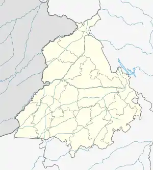 Sardulgarh Location in Punjab, India  Sardulgarh Sardulgarh (India) | |
| Coordinates: 29.697°N 75.238752°E | |
| Country | |
| State | Punjab |
| District | Mansa |
| Elevation | 210 m (690 ft) |
| Population (2001) | |
| • Total | 16,315 |
| Languages | |
| • Official | Punjabi |
| Time zone | UTC+5:30 (IST) |
Geography
Sardulgarh is located in the south region of Punjab State. The longitude and latitude at 29.697°N 75.238752°E.[1] It has an average elevation of 210 metres (688 feet). It is a city located around the bank of River Ghagar. It is surrounded and touch the border of Haryana State from 3 sides. Its boundary touches to 3 districts (Bathinda, Sirsa and Fatehabad).
Demographics
As of 2001 India census,[2] Sardulgarh had a population of 16,315. Males constitute 54% of the population and females 46%. Sardulgarh has an average literacy rate of 65%, more than the national average of 59.5%: male literacy is 72%, and female literacy is 61%.
References
- Falling Rain Genomics, Inc - Sardulgarh
- "Census of India 2001: Data from the 2001 Census, including cities, villages and towns (Provisional)". Census Commission of India. Archived from the original on 16 June 2004. Retrieved 1 November 2008.
