Gurdaspur district
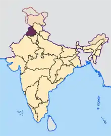
Gurdaspur district is a district in the Majha region of the state of Punjab, India. Gurdaspur is the district headquarters. It internationally borders Narowal District of the Pakistani Punjab, the Punjab districts of Amritsar, Pathankot, Kapurthala and Hoshiarpur. Two main rivers Beas and Ravi passes through the district. The Mughal emperor Akbar is said to have been enthroned in a garden near Kalanaur, a historically important town in the district.[1] The district is at the foothills of the Himalayas.
Gurdaspur district | |
|---|---|
District | |
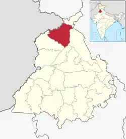
 Location in Punjab, India | |
| Coordinates: 31°55′N 75°15′E | |
| Country | |
| State | Punjab |
| Headquarters | Gurdaspur |
| Area | |
| • Total | 2,610 km2 (1,010 sq mi) |
| Population (2011)[‡] | |
| • Total | 2,298,323 |
| • Density | 880/km2 (2,300/sq mi) |
| Languages | |
| • Official | Punjabi |
| Time zone | UTC+5:30 (IST) |
| Literacy | 79.95% |
| Website | gurdaspur |
As of 2011 it is the third most populous district of Punjab (out of 22), after Ludhiana and Amritsar.[2] Batala, with 31% of the district's population, is its largest city.
History

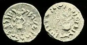
Obv: Standing figure, probably of Vishvamitra, Kharoshthi legend, around: Mahadevasa Dharaghoshasa/Odumbarisa "Great Lord King Dharaghosha/Prince of Audumabara", across: Viçvamitra "Vishvamitra".
Rev: Trident battle-axe, tree with railing, Brahmi legend identical in content to the obverse.[3]
From the latter half of the 10th century up to 1919 A.D. this district was ruled by the Shahi dynasty under Jayapal and Anandpal. Kalanaur in this district was the most important town during the period of Delhi Emperor from the 14th to 16th centuries. It was twice attacked by Jasrath Khokhar, once after his unsuccessful assault on Lahore in 1422 and again in 1428 when Malik Sikander marched to relieve the place and defeated Jasrath AkIar was installed by Bairam Khan on a throne on Feb 1556. The messonary, a platform which still exists about a kilometre and a half to the east of the town is the actual spot upon which his installation took place.
In the decline and fall of the Mughal supremacy and the rise of the Sikh power this district saw its most stirring scenes. Some of the Sikh Gurus have been closely associated with the district. Guru Nanak, born in 1469 in the Lahore district, married in 1485 with Sulkhani, daughter of Mool Chand, a Khatri of Pakhoke (Dera Baba Nanak) in the Batala Tehsil. There is still a wall known as Jhoolana Mahal which swings in Gurdaspur. The Sikh Guru Hargobind refounded Sri Hargobindpur which had been formerly known by the name of Rahila. Banda Singh Bahadur, the disciple of Guru Gobind Singh used this district as a base to raid the country up to Lahore, the emperor Bahadur Shah conducted an expedition against him in 1711 but with only temporary effect. Banda Bahadar fought his last battle with the Mughal at Gurdas Nangal in the district and was captured. The history of the district then degenerates into an account of their struggles with the rival Ramgarhia Misl and Kanhaiya Misls for supremacy in this part of the Doab, the power of the former was broken in 1808 and of the latter in 1811.
Maharaja Ranjit Singh thus assumed way over the whole district. Dina Nagar, with its pleasant mango gardens and running canal was a favourite summer residence of the lion of the Punjab, who when not elsewhere engaged spent the two hot weather months of May and June here.
During British Rule the district of Gurdaspur was a subdivision of Lahore Division, the district itself was administratively subdivided into four tehsils: Gurdaspur, Batala, Shakargarh and Pathankot. According to the 1881 census the population of the district was 823,695 this had risen by over 100,000 to 943,922 in the 1891 census. However the 1901 census recorded a fall in population – 940,334, this was largely due to emigration – some 44,000 settlers settling in Chenab colony. According to the 1901 census there were 463,371 Muslims (49%), 380,636 Hindus (over 40%) and 91,756 (10%) Sikhs. Mirza Ghulam Ahmad who founded the Ahmadiyya movement had followers here.[4]
During the partition of India in 1947 the future of Gurdaspur was highly contested. According to the 1941 census, the population of this district had a narrow 51.14% Muslim majority. Radcliffe Award of the boundary gave only the Shakargarh tehsil of the district to Pakistan, and the rest to India. The Muslim population of the eastern tehsils migrated to Pakistan as refugees, and the Hindus and Sikhs of Shakargarh migrated to Gurdaspur after crossing the Ravi Bridge. They settled and spread in the Gurdaspur district.
On 27 July 2011 a part of district is carved out to form a new Pathankot district, which was earlier part of Gurdaspur. The Pathankot district comprises two sub-divisions of Pathankot and Dharkalan along with two sub-tehsils namely Narot Jaimal Singh and Bamial.
Geography
Location
The Gurdaspur district is in the north of Punjab state. It falls in the Jalandhar division and is sandwiched between rivers Ravi and Beas. The district lies between north-latitude 310-36' and 320-34' and east longitude 740-56' and 750-24' and shares common boundaries with Pathankot district in the north, Beas River in the north-east, Hoshiarpur district in the south-east, Kapurthala district in the south, Amritsar district in the south-west and Pakistan in the north-west.
Topography

All the Tehsils of the district namely Gurdaspur, Batala and Dera Baba Nanak are plain and similar to the rest of the Punjab plains in structure. The landscape of the district has varied topography comprising undulating plan, the flood plains of the Ravi and the Beas and the upland plain.
To its south lies an area of about 128 km2 which is highly dissected and is an undulating plain. Its elevation ranges from about 305 to 381 metres above sea level. It is traversed by a number of choas and has an undulating topography.
The flood plains of the Ravi and the Beas are separated from the upland plain by sharp river-cut bluffs. They are low lying, with slightly uneven topography. Sand dominates in the soil structure of the flood plains, but it diminishes in both quantity and coarseness in the upland plain. The upland plain covers a large part of the district particularly. Its elevation ranges from about 305 metres above sea level in the north-east to about 213 metres above sea level in the south-west, with a gentle gradient of about 1 metre in 1.6 km.
Government and politics
Tehsil
|
Sub Tehsils (Total : 7)
| Sr. No. | Sub Tehsil Name |
|---|---|
| 1. | Kahnuwan |
| 2. | Sri Hargobindpur |
| 3. | Qadian |
| 4. | Dinanagar |
| 5. | Fatehgarh Churian |
| 6. | Dhariwal |
| 7. | Naushera Majha Singh |
C.D. Blocks (Total : 11)
| Sr. No. | Block Name |
|---|---|
| 1. | Gurdaspur |
| 2. | Kalanaur |
| 3. | Dhariwal |
| 4. | Kahnuwan |
| 5. | Dinanagar |
| 6. | Batala |
| 7. | Fatehgarh Churian |
| 8. | Dera Baba Nanak |
| 9. | Sri Hargobindpur |
| 10. | Qadian |
| 11. | Dorangla |
Municipal Councils
| Sr. No. | Municipal Name |
|---|---|
| 1. | Gurdaspur |
| 2. | Dhariwal |
| 3. | Dinanagar |
| 4. | Batala |
| 5. | Sri Hargobindpur |
| 6. | Dera Baba Nanak |
| 7. | Fatehgarh Churian |
| 8. | Qadian |
Demographics
| Year | Pop. | ±% p.a. |
|---|---|---|
| 1901 | 702,372 | — |
| 1911 | 622,008 | −1.21% |
| 1921 | 634,394 | +0.20% |
| 1931 | 718,523 | +1.25% |
| 1941 | 854,968 | +1.75% |
| 1951 | 851,140 | −0.04% |
| 1961 | 980,868 | +1.43% |
| 1971 | 1,229,464 | +2.28% |
| 1981 | 1,513,435 | +2.10% |
| 1991 | 1,756,732 | +1.50% |
| 2001 | 2,103,455 | +1.82% |
| 2011 | 2,298,323 | +0.89% |
| source:[5] | ||
Population
According to the 2011 census Gurdaspur district has a population of 2,298,323,[2] roughly equal to the nation of Latvia[6] or the US state of New Mexico.[7] This gives it a ranking of 196th in India (out of a total of 640).[2] The district has a population density of 649 inhabitants per square kilometre (1,680/sq mi).[2] Its population growth rate over the decade 2001–2011 was 9.3%.[2] Gurdaspur has a sex ratio of 895 females for every 1000 males,[2] and a literacy rate of 79.95%.[2]
Religion
Hinduism ( 46%) and Sikhism ( 43% ) are the main religions of Gurdaspur district. Gurdaspur also has the highest share (7.7%) of Christians in the state.[8]
Notable people
- Dev Anand(Indian actor)
- Premchand Dogra (Mr. Universe, Mr. India)
- Gurbachan Singh Salaria(Param Vir Chakra)
- Chetan Anand (director)
- Vijay Anand (director)
- Vinod Khanna(Indian actor)
- Shiv Kumar Batalvi (Punjabi writer)
- Dilbagh Singh (Air Chief Marshal)
- Dinesh Khanna(Badminton)
- Romesh Sharma (Indian Actor)
- Jasbir Jassi (Bhangra singer)
- Lt. Navdeep Singh (Ashoka Chakra Award)
- Guru Randhawa(Punjabi singer)
- Preet Harpal (Punjabi singer)
- Ashwani Kumar (politician)
- Robert Masih Nahar
- Shivil Kaushik (cricketer)
- Teja Singh Akarpuri
- Iqbal Bahu (Sufi singer)
- Ishfaq Ahmad(nuclear physicist)
- Alla Rakha (Tabla player)
- Nek Chand Saini(Rock Garden Chandigarh)
- Gurpreet Ghuggi(comedian,politician)
- Ranjit Bawa (Punjabi singer)
- Nimrat khaira(Punjabi singer)
- Satinder Satti(anchor-singer)
- Manpreet Gony (Cricketer)
- Varinder Singh Ghuman
- Surjit Singh Randhawa (hockey player)
- Principal Sujan Singh(writer)
- Teja Singh (singh sabha movement)
- Prabhjot Singh(Indian hockey player)
- Sobha Singh (painter)
- Partap Singh Bajwa(politician)
- Baba Jaimal Singh
- Mirza Nasir Ahmad(Khalifatul Massih III)
- Mirza Tahir Ahmad(Khalifatul Massih IV)
- Mirza Ghulam Ahmad(Ahmadiyya Movement)
- Mirza Basheer-ud-Din Mahmood Ahmad(Khalifatul Massih II)
- Ghulam Ahmed Pervez(magazine-Tolu-e-Islam)
- Mumtaz Mufti(Renowned writer)
- Sunanda Sharma (Punjabi singer)
References
- "About District". gurdaspur.nic.in. Archived from the original on 2 August 2005. Retrieved 29 March 2018.
- "District Census 2011". Census2011.co.in. 2011. Retrieved 30 September 2011.
- Ancient India, from the earliest times to the first century, A.D by Rapson, E. J. p.154
- "Imperial Gazetteer2 of India, Volume 12, page 395 -- Imperial Gazetteer of India -- Digital South Asia Library". dsal.uchicago.edu. Retrieved 29 March 2018.
- Decadal Variation In Population Since 1901
- US Directorate of Intelligence. "Country Comparison:Population". Retrieved 1 October 2011.
Latvia 2,204,708 July 2011 est.
- "2010 Resident Population Data". U. S. Census Bureau. Retrieved 30 September 2011.
New Mexico – 2,059,179
- http://www.censusindia.gov.in/2011census/C-01/DDW03C-01%20MDDS.XLS
