Sassandra
Sassandra is a town in southern Ivory Coast. It is a sub-prefecture of and the seat of Sassandra Department. It is also a commune and the seat of Gbôklé Region in Bas-Sassandra District.
Sassandra | |
|---|---|
Town, sub-prefecture, and commune | |
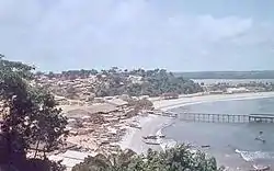 A beach in Sassandra | |
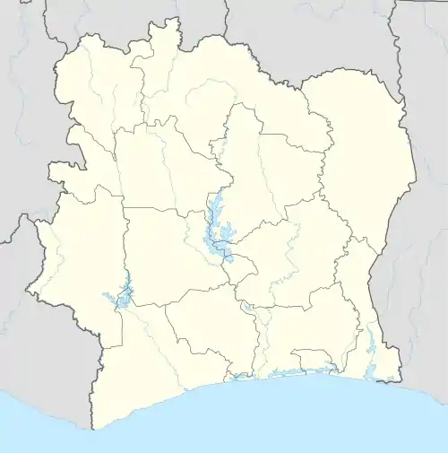 Sassandra Location in Ivory Coast | |
| Coordinates: 4°57′N 6°5′W | |
| Country | |
| District | Bas-Sassandra |
| Region | Gbôklé |
| Department | Sassandra |
| Population (2014)[1] | |
| • Total | 72,221 |
| Time zone | UTC+0 (GMT) |
Sassandra lies on the Gulf of Guinea at the mouth of the Sassandra River. The town was founded by the Portuguese as Santo André and was later run by the British, then the French as a seaport for timber. The town declined in the 1960s after San Pédro's port was completed. Sassandra's main industry is now fishing.
Sassandra is known for its beaches and lighthouse, while the Gaoulou National Park lies nearby. It is served by Sassandra Airport.
In 2014, the population of the sub-prefecture of Sassandra was 72,221.[2]
Villages
The thirty eight villages of the sub-prefecture of Sassandra and their population in 2014 are:[2]
- Arokpa (363)
- Bassa (492)
- Batélébré 1 (94)
- Brodjé (431)
- Cocoplage (296)
- Dabéda (169)
- Gaoulou (12 184)
- Gapé (318)
- Grand-Dréwin (747)
- Kadrokpa (1 683)
- Lébléko (151)
- Lékidou (63)
- Misséhi (292)
- Niani (839)
- Niézéko (222)
- Sassandra (26 608)
- Siampaho Pk6 (855)
- Vodiéko (286)
- Akakro (863)
- Dagbégo 1 (1 025)
- Dagbégo 2 (2 042)
- Gloplou Pk20 (496)
- Godé (180)
- Goviadou (39)
- Guédio-Guédio (720)
- Kadrokpa 2 (2 911)
- Latéko (233)
- Lipoyo (1 079)
- Lohiri-Néyau (326)
- Lossan Kouamékro (2 313)
- Louga (889)
- Niabably Pk 26 (3 323)
- Niabayo (89)
- Niéga (328)
- Pauly-Brousse (6 530)
- Pauly-Chantier (623)
- Pauly-Plage (162)
- Sialloukro (2 957)
Climate
| Climate data for Sassandra (1961–1990) | |||||||||||||
|---|---|---|---|---|---|---|---|---|---|---|---|---|---|
| Month | Jan | Feb | Mar | Apr | May | Jun | Jul | Aug | Sep | Oct | Nov | Dec | Year |
| Average high °C (°F) | 30.1 (86.2) |
30.1 (86.2) |
31.0 (87.8) |
30.9 (87.6) |
29.8 (85.6) |
27.9 (82.2) |
27.1 (80.8) |
26.5 (79.7) |
27.5 (81.5) |
28.5 (83.3) |
29.6 (85.3) |
29.5 (85.1) |
29.0 (84.2) |
| Daily mean °C (°F) | 26.1 (79.0) |
26.9 (80.4) |
27.0 (80.6) |
26.5 (79.7) |
26.5 (79.7) |
25.4 (77.7) |
24.5 (76.1) |
24.2 (75.6) |
24.6 (76.3) |
25.5 (77.9) |
26.2 (79.2) |
26.1 (79.0) |
25.8 (78.4) |
| Average low °C (°F) | 22.3 (72.1) |
23.0 (73.4) |
23.2 (73.8) |
23.4 (74.1) |
23.1 (73.6) |
22.0 (71.6) |
22.7 (72.9) |
22.0 (71.6) |
22.0 (71.6) |
22.4 (72.3) |
22.8 (73.0) |
22.6 (72.7) |
22.6 (72.7) |
| Average rainfall mm (inches) | 15.8 (0.62) |
35.7 (1.41) |
52.6 (2.07) |
96.9 (3.81) |
235.1 (9.26) |
529.1 (20.83) |
191.4 (7.54) |
32.1 (1.26) |
43.6 (1.72) |
84.5 (3.33) |
119.6 (4.71) |
72.8 (2.87) |
1,509.2 (59.42) |
| Mean monthly sunshine hours | 208.3 | 192.4 | 211.4 | 218.3 | 182.5 | 112.1 | 128.8 | 123.8 | 154.4 | 216.0 | 224.2 | 206.2 | 2,178.4 |
| Source: NOAA[3] | |||||||||||||
External links
- (in French) Neyo project : Collaborative project on culture and language of Neyo people, from Sassandra (Côte d'Ivoire)
 Sassandra travel guide from Wikivoyage
- "Côte d'Ivoire". geohive.com. Archived from the original on 24 November 2015. Retrieved 7 December 2015.
- "RGPH 2014, Répertoire des localités, Région Gbôklé" (PDF). ins.ci. Retrieved 5 August 2019.
- "Sassandra–Aero Climate Normals 1961–1990". National Oceanic and Atmospheric Administration. Retrieved December 21, 2015.
Regional seat: Sassandra | ||
| Fresco Department |  | |
| Sassandra Department | ||
* also a commune | ||
