Satteldorf
Satteldorf is a town in the district of Schwäbisch Hall in Baden-Württemberg in Germany.
Satteldorf | |
|---|---|
 Coat of arms | |
Location of Satteldorf within Schwäbisch Hall district 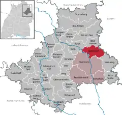 | |
 Satteldorf  Satteldorf | |
| Coordinates: 49°10′05″N 10°04′51″E | |
| Country | Germany |
| State | Baden-Württemberg |
| Admin. region | Stuttgart |
| District | Schwäbisch Hall |
| Subdivisions | 25 Ortsteile |
| Government | |
| • Mayor | Kurt Wackler |
| Area | |
| • Total | 46.21 km2 (17.84 sq mi) |
| Elevation | 421 m (1,381 ft) |
| Population (2019-12-31)[1] | |
| • Total | 5,579 |
| • Density | 120/km2 (310/sq mi) |
| Time zone | UTC+01:00 (CET) |
| • Summer (DST) | UTC+02:00 (CEST) |
| Postal codes | 74589 |
| Dialling codes | 07951 |
| Vehicle registration | SHA |
| Website | www.satteldorf.de |
Geography
Satteldorf is located on the Hohenloher level on the Jagst, a right tributary of the Neckar, about 4 km north of Crailsheim. The eastern districts are located directly on the Frankenhöhe. The municipality is bordered to the north by Wallhausen , to the east by the Bavarian municipality of Schnelldorf, to the southeast by Kreßberg, to the south by Crailsheim and to the west by the town of Kirchberg an der Jagst.
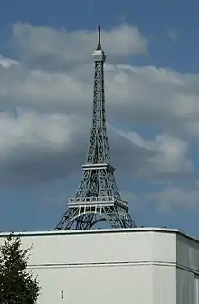
Replica of Eiffel Tower on factory building at Satteldorf near Crailsheim, Germany
References
- "Bevölkerung nach Nationalität und Geschlecht am 31. Dezember 2019". Statistisches Landesamt Baden-Württemberg (in German). September 2020.
| Authority control |
|---|
This article is issued from Wikipedia. The text is licensed under Creative Commons - Attribution - Sharealike. Additional terms may apply for the media files.