Schenkendöbern
Schenkendöbern (Lower Sorbian Derbno) is a municipality in the district of Spree-Neiße, in Brandenburg, Germany.
Schenkendöbern | |
|---|---|
Location of Schenkendöbern within Spree-Neiße district 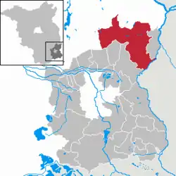 | |
 Schenkendöbern  Schenkendöbern | |
| Coordinates: 51°56′01″N 14°37′20″E | |
| Country | Germany |
| State | Brandenburg |
| District | Spree-Neiße |
| Government | |
| • Mayor | Peter Jeschke (CDU) |
| Area | |
| • Total | 213.89 km2 (82.58 sq mi) |
| Elevation | 51 m (167 ft) |
| Population (2019-12-31)[1] | |
| • Total | 3,572 |
| • Density | 17/km2 (43/sq mi) |
| Time zone | UTC+01:00 (CET) |
| • Summer (DST) | UTC+02:00 (CEST) |
| Postal codes | 03172 |
| Dialling codes | 03561, 035691, 035692, 035693 |
| Vehicle registration | SPN |
| Website | www.schenkendoebern.de |
Demography
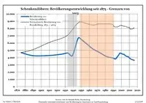 Development of population since 1875 within the current Boundaries (Blue Line: Population; Dotted Line: Comparison to Population development in Brandenburg state; Grey Background: Time of Nazi Germany; Red Background: Time of communist East Germany)
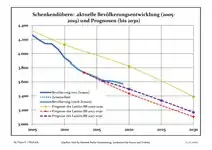 Recent Population Development and Projections (Population Development before Census 2011 (blue line); Recent Population Development according to the Census in Germany in 2011 (blue bordered line); Official projections for 2005-2030 (yellow line); for 2014-2030 (red line); for 2017-2030 (scarlet line)
|
|
|
References
- "Bevölkerung im Land Brandenburg nach amtsfreien Gemeinden, Ämtern und Gemeinden 31. Dezember 2019". Amt für Statistik Berlin-Brandenburg (in German). July 2020.
- Detailed data sources are to be found in the Wikimedia Commons.Population Projection Brandenburg at Wikimedia Commons
| Authority control |
|
|---|
This article is issued from Wikipedia. The text is licensed under Creative Commons - Attribution - Sharealike. Additional terms may apply for the media files.