Seßlach
Seßlach is a town in the district of Coburg, in northern Bavaria, Germany. It is situated 12 km southwest of Coburg and has a population close to 4,000.
Seßlach | |
|---|---|
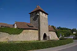 Town gate | |
 Coat of arms | |
Location of Seßlach within Coburg district 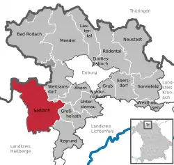 | |
 Seßlach  Seßlach | |
| Coordinates: 50°10′N 10°50′E | |
| Country | Germany |
| State | Bavaria |
| Admin. region | Oberfranken |
| District | Coburg |
| Subdivisions | 14 villages one town |
| Government | |
| • Mayor | Maximilian Neeb (FW) |
| Area | |
| • Total | 72.51 km2 (28.00 sq mi) |
| Elevation | 271 m (889 ft) |
| Population (2019-12-31)[1] | |
| • Total | 3,922 |
| • Density | 54/km2 (140/sq mi) |
| Time zone | UTC+01:00 (CET) |
| • Summer (DST) | UTC+02:00 (CEST) |
| Postal codes | 96145 |
| Dialling codes | 09569 |
| Vehicle registration | CO |
| Website | www.sesslach.de |
Seßlach is notable for its largely intact medieval town wall and overall historic appearance with few modern structures.
Geography
Location
Seßlach is located in Upper Franconia. To the north, the municipal territory borders on Thuringia. To the west and south lies the district Haßberge.
Subdivisions
Seßlach consists of 17 Stadtteile:
[2]
(inhabitants as of July 2015)[3]
|
|
|
History
The first written mention of the two settlements on the Kirchhügel (church hill) and the Geiersberg (vulture hill) comes from the year 800. The Abbess Emhild of the monastery Milz transferred the monasterial properties by this certificate to Fulda Abbey.
In 1335, the emperor Ludwig der Bayer awarded Seßlach the status of town. This gave the residents the permission to fortify their settlement which they soon did. By 1343 the first town gate had been erected. Later that century, the town became the seat of an Amt and a Centgericht of the Prince-Bishop of Würzburg.[4]:154
Seßlach was part of the Hochstift Würzburg until secularization in 1803. Over the centuries, the town suffered more under the German Peasants' War (1525) than nearby Coburg and was also damaged and plundered during the Thirty Years' War, the Seven Years' War and the Napoleonic Wars.[4]:154
In 1810, the Amt Seßlach came to the Kingdom of Bavaria and gradually lost importance. In 1812, an Amtsgericht was established but in the 1929 Staatsreform it was sidelined. In 1972, Seßlach became part of the Landkreis Coburg.[4]:154
Attractions
Seßlach is notable for its largely intact medieval town wall and overall historic appearance with few modern structures. It features many half-timbered buildings. The parish church, St. Johannes, was built in the 13th century and later redesigned in Baroque style.[4]:154–5
The 2006 movie of The Robber Hotzenplotz was filmed in Seßlach.
Infrastructure
Transport
Bundesstrasse 303 passes through the municipal territory north of the town itself.
References
- "Tabellenblatt "Daten 2", Statistischer Bericht A1200C 202041 Einwohnerzahlen der Gemeinden, Kreise und Regierungsbezirke". Bayerisches Landesamt für Statistik und Datenverarbeitung (in German). July 2020.
- www.sesslach.de Stadtteile
- www.sesslach.de Zahlen Daten
- Klüglein, Norbert (1991). Coburg Stadt und Land (German). Verkehrsverein Coburg.
External links
| Wikimedia Commons has media related to Seßlach. |
Towns and municipalities in Coburg (district) | ||
|---|---|---|
Coat of Arms of Coburg district | ||
| Authority control |
|---|