Upper Franconia
Upper Franconia (German: Oberfranken) is a Regierungsbezirk (administrative [Regierungs] region [bezirk]) of the state of Bavaria, southern Germany. It forms part of the historically significant region of Franconia (See also: Middle Franconia and Lower Franconia), all now part of the German Federal State of Bayern (Bavaria).
Upper Franconia
Oberfranken | |
|---|---|
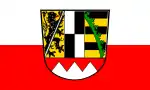 Flag  Coat of arms | |
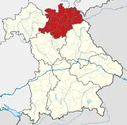 Map of Bavaria highlighting Upper Franconia | |
| Country | Germany |
| State | Bavaria |
| Region seat | Bayreuth |
| Area | |
| • Total | 7,230.19 km2 (2,791.59 sq mi) |
| Population (31 December 2019)[1] | |
| • Total | 1,065,371 |
| • Density | 150/km2 (380/sq mi) |
| Website | regierung.oberfranken.bayern.de |
With more than 200 independent breweries which brew approximately 1000 different types of beer, Upper Franconia has the world's highest brewery-density per capita. A special Franconian beer route (Fränkische Brauereistraße) leads along popular breweries.
Geography
The administrative region borders on Thuringia (Thüringen) to the north, Lower Franconia (Unterfranken) to the west, Middle Franconia (Mittelfranken) to the south-west, and Upper Palatinate (Oberpfalz) to the south-east, Saxony (Sachsen) to the north-east and the Czech Republic to the east.
History
After the founding of the Kingdom of Bavaria the state was totally reorganised and, in 1808, divided into 15 administrative government regions (German: Regierungsbezirke (singular Regierungsbezirk)), in Bavaria called Kreise (singular: Kreis). They were created in the fashion of the French departements, quite even in size and population, and named after their main rivers.
In the following years, due to territorial changes (e. g. loss of Tyrol, addition of the Palatinate), the number of Kreise was reduced to 8. One of these was the Mainkreis (Main District). In 1837 king Ludwig I of Bavaria renamed the Kreise after historical territorial names and tribes of the area. This also involved some border changes or territorial swaps. Thus the name Mainkreis changed to Upper Franconia.
Main sights
Next to the former episcopal residence city of Bamberg, the capital Bayreuth, the former residence city of Coburg and the classicist downtown of Hof as well as the towns of Lichtenfels, Kronach, Gößweinstein and Kulmbach, the Weißenstein Palace, Banz Abbey and the Basilica of the Fourteen Holy Helpers, the scenic attractions of the River Main and the low mountain ranges of Fichtel Mountains with the town of Wunsiedel and the Franconian Forest belong to the major tourist attractions. There are also numerous spas like Bad Rodach, Bad Steben, Bad Staffelstein, Bad Berneck and Bad Alexandersbad.
Coat of arms
| The coat of arms displays: |
Administrative subdivisions
Oberfranken is subdivided into nine Landkreise (districts) and four Kreisfreie Städte (district-free or independent cities).
Landkreise:
Kreisfreie Städte:
Historical population
| Year | Population |
|---|---|
| 1900 | 608,116 |
| 1910 | 661,862 |
| 1939 | 790,151 |
| 1950 | 1,088,721 |
| 1961 | 1,056,087 |
| 1970 | 1,079,131 |
| 1987 | 1,036,576 |
| 2002 | 1,112,655 |
| 2005 | 1,101,390 |
| 2006 | 1,094,525 |
| 2008 | 1,085,770 |
| 2010 | 1,071,984 |
| 2015 | 1,059,358 |
| 2019 | 1,065,371 |
Economy
The Gross domestic product (GDP) of the region was 40.6 billion € in 2018, accounting for 1.2% of German economic output. GDP per capita adjusted for purchasing power was 34,900 € or 116% of the EU27 average in the same year. The GDP per employee was 96% of the EU average.[2]
See also
- Middle Franconia (Mittelfranken)
- Lower Franconia (Unterfranken)
References
- "Tabellenblatt "Daten 2", Statistischer Bericht A1200C 202041 Einwohnerzahlen der Gemeinden, Kreise und Regierungsbezirke". Bayerisches Landesamt für Statistik und Datenverarbeitung (in German). July 2020.
- "Regional GDP per capita ranged from 30% to 263% of the EU average in 2018". Eurostat.
External links
- Official website (in German)
- Sights in Frankonia (in German)
Administrative regions (Regierungsbezirk) of Bavaria | |||
|---|---|---|---|
| Regions | |||
| Former region |
| ||
| Authority control |
|---|