Sehr Bagla
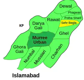
Sehr Bagla (سہر بگلہ) is a Village and Union Council of Murree Tehsil in the Rawalpindi District of Punjab, Pakistan.[1] It is located in the north-east of the Tehsil and is bounded to the north by Potha Sharif, to the south by Ghel, to the west by Rawat and to the east by Kashmir
Sehr Bagla | |
|---|---|
 View from upper Sehr Bagla | |
| Province | Punjab |
| District | Rawalpindi |
| Tehsil | Murree |
| Population | |
| • Total | 10,979 (1,998 Census) |
According to the 1998 census of Pakistan, it had a population of 10,979.[2]
Schools and education
There are 18 primary schools and 3 secondary schools in UC Sehr Bagla, some are listed below:
- Hira Secondary School
- Hira Public School Gohi Birgran
- Suffah School of Islamic Studies
- GHS Riaz Model High
- GGPS Primary Hoterian
- GGPS Neargoli
- GBPS Sehr
- GBPS Reunty
- GBPS Birgran
- GBPS Gohi
Facilities
Sehr Bagla is home to predominantly poor inhabitants, the area is economically deprived due to lack of government investment and infrastructure development, basic essentials i.e. clean water supply, gas, safe roads and higher education have not been established, due to this most of the inhabitants are economically disadvantaged and many have had to move to the nearby cities of Islamabad and Rawalpindi to pursue better opportunities. There are some basic services and facilities available:

- Basic Health Unit
- Forest Office
- Post Office
- PCO Public Call Office
- Jeep Hire
- Fruit Market & Grocery Stores, Butcher, Bakery, Tandoor(Clay Oven)
- Gas Cylinder Re-fill Facility
- Jamia Mosque
- Volleyball Court
- Restaurant & Cafe
Mosques
There are numerous Mosques in UC Sehr Bagla, most villages within the UC have constructed local mosques, some of the more prominent Mosques are listed below,
- Jamia Masjid (Sehr Bagla Bazaar)
- Munawwar Masjid (Mid Sehr Bagla)
- Allah Wali Masjid (Upper Sehr Bagla)
- Jamia Masjid Neargoli
- Jamia Masjid Kasseri
- Masjid Reunty
- Jamia Masjid Birgran (3 Mosques)
- Jamia Masjid Gohi
Tribes
As with the majority of the Murree Hills the main tribe settled in Sehr Bagla are the Dhund Abbasi, there are also members of the Kethwal and Dhanyal tribes settled in the area.
The northern half of the Murree Tehsil is held entirely by the Dhund, who claim to be Abbasi Arabs, claiming descent from the Prophet Mohammad's uncle Abbas ibn Abdul Mutalib. The Satti tribe, which claims Rajput ancestry is found confined to the hilly Kotli Sattian Tehsil. In between these two tribes, are wedged the Kethwal, who claim descent from the Greek general Alexander the Great. The Dhanyal hold the western half of the Murree Tehsil, known as the Karor illaqa, as well as villages in the Islamabad Capital Territory. Like the Awan, the Dhanyal claim descent from the Prophet Mohammed's son in-law Ali. The smallest of the Murree Hill tribes are the Jasgam, who hold several villages in the hilly portion of the Kahuta Tehsil. Like the Dhund, they claim to be Abbasi Arabs.
Transport
- Suzuki Carry, Jeeps are a common form of transport from Gohi and Birgran to Sehr Bagla, Taxis (for local travel)
- Buses & Toyota Vans for Muzaffarabad & Rawalpindi/Islamabad
- Ghilani Coach Service for Lahore & Karachi
Localities
Sozo Adventure Park, Patriata Chair Lift, Murree Town, Bhurban Chair Lift, Kohala Bridge, Ayubia National Park, Nathia Gali, Islamabad City, Rawalpindi City, Pearl Continental (Bhurban).
References
- Towns & Unions in the City District of Rawalpindi - Government of Pakistan Archived 2008-01-24 at the Wayback Machine
- Official Website of City District Rawalpindi Archived 2008-03-13 at the Wayback Machine

| Climate data for Sehr Bagla | |||||||||||||
|---|---|---|---|---|---|---|---|---|---|---|---|---|---|
| Month | Jan | Feb | Mar | Apr | May | Jun | Jul | Aug | Sep | Oct | Nov | Dec | Year |
| Record high °C (°F) | 17.2 (63.0) |
19.8 (67.6) |
23.0 (73.4) |
26.0 (78.8) |
32.0 (89.6) |
32.2 (90.0) |
31.7 (89.1) |
27.2 (81.0) |
25.6 (78.1) |
25.0 (77.0) |
22.3 (72.1) |
21.1 (70.0) |
32.2 (90.0) |
| Average high °C (°F) | 7.2 (45.0) |
7.5 (45.5) |
11.6 (52.9) |
17.2 (63.0) |
21.7 (71.1) |
25.1 (77.2) |
22.4 (72.3) |
21.4 (70.5) |
20.9 (69.6) |
18.6 (65.5) |
14.5 (58.1) |
10.2 (50.4) |
16.5 (61.8) |
| Daily mean °C (°F) | 3.7 (38.7) |
4.0 (39.2) |
8.0 (46.4) |
13.2 (55.8) |
17.3 (63.1) |
20.6 (69.1) |
19.1 (66.4) |
18.4 (65.1) |
17.2 (63.0) |
14.3 (57.7) |
10.3 (50.5) |
6.3 (43.3) |
12.7 (54.9) |
| Average low °C (°F) | 0.1 (32.2) |
0.5 (32.9) |
4.3 (39.7) |
9.1 (48.4) |
12.8 (55.0) |
16.1 (61.0) |
15.7 (60.3) |
15.4 (59.7) |
13.4 (56.1) |
10.1 (50.2) |
6.2 (43.2) |
2.4 (36.3) |
8.8 (47.9) |
| Record low °C (°F) | −8.4 (16.9) |
−10.6 (12.9) |
−7 (19) |
−3.3 (26.1) |
0.6 (33.1) |
3.6 (38.5) |
8.9 (48.0) |
10.0 (50.0) |
6.0 (42.8) |
1.1 (34.0) |
−3.3 (26.1) |
−10.5 (13.1) |
−10.6 (12.9) |
| Average precipitation mm (inches) | 126.5 (4.98) |
145.0 (5.71) |
176.8 (6.96) |
133.0 (5.24) |
91.9 (3.62) |
130.3 (5.13) |
339.3 (13.36) |
326.3 (12.85) |
146.5 (5.77) |
70.2 (2.76) |
32.5 (1.28) |
70.3 (2.77) |
1,788.6 (70.43) |
| Source: NOAA (1961–1990)[1] | |||||||||||||
- "Murree Climate Normals 1961–1990". National Oceanic and Atmospheric Administration. Retrieved January 16, 2013.