Semenov Peak
Semenov Peak (Russian: Пик Семёнова, romanized: Pik Semonova) is a mountain in the Tian Shan on the border between Kyrgyzstan and Kazakhstan.[2]
| Semenov Peak | |
|---|---|
| Pik Semonova | |
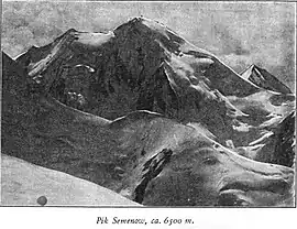 Taken by German geographer Gottfried Merzbacher in 1902/3 | |
| Highest point | |
| Elevation | 5,816 m (19,081 ft) [1] |
| Prominence | 802 m (2,631 ft) [1] |
| Coordinates | 42°16′34″N 80°7′5″E |
| Geography | |
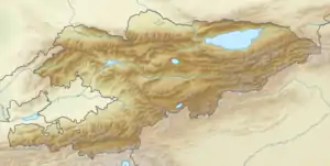 Semenov Peak  Semenov Peak Semenov Peak (Kazakhstan) | |
| Parent range | Tian Shan |
The 5,816-metre (19,081 ft) high mountain is located 8.64 km northwest of Khan Tengri (6995 m) on the opposite side of the Northern Engilchek Glacier.
History
The peak is named for the Russian geographer Peter Semenov-Tian-Shansky.
References
- "Semionova". Peakbagger.com. Retrieved 2020-11-20.
- "Pik Semenova". peakvisor.com. Retrieved 2020-11-20.
This article is issued from Wikipedia. The text is licensed under Creative Commons - Attribution - Sharealike. Additional terms may apply for the media files.