Seminole, Oklahoma
Seminole is a city in Seminole County, Oklahoma, United States. The population was 7,488 at the 2010 census. Seminole experienced a large population growth in the 1920s due to an oil boom.[5]
Seminole, Oklahoma | |
|---|---|
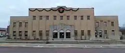 The Seminole Municipal Building, which is on the National Register of Historic Places | |
 Location of Seminole, Oklahoma | |
| Coordinates: 35°14′28″N 96°40′6″W | |
| Country | United States |
| State | Oklahoma |
| County | Seminole |
| Area | |
| • Total | 14.64 sq mi (37.91 km2) |
| • Land | 14.09 sq mi (36.48 km2) |
| • Water | 0.55 sq mi (1.42 km2) |
| Elevation | 892 ft (272 m) |
| Population (2010) | |
| • Total | 7,488 |
| • Estimate (2019)[2] | 7,041 |
| • Density | 499.86/sq mi (193.00/km2) |
| Time zone | UTC-6 (Central (CST)) |
| • Summer (DST) | UTC-5 (CDT) |
| ZIP codes | 74818, 74868 |
| Area code(s) | 405 |
| FIPS code | 40-66350[3] |
| GNIS feature ID | 1097908[4] |
| Website | www.seminole-oklahoma.net |
History
The city was platted in 1906 as a relocation setting for the residents of Tidmore, when the railroad line was placed north of the town.[6] When Oklahoma Territory and Indian Territory merged to become the U.S. state of Oklahoma in 1907, there were 206 residents.[6]
Seminole competed to be the county seat of Seminole County, but lost out to Wewoka.[7]
Upon the discovery of a high-producing oil well in the city in 1926, Seminole transformed from a town of 854 to a boom town of 25,000 to 30,000 residents.[6][8] In August 1970 Seminole hosted its first All-Night Gospel Singing. During its heyday an estimated twenty-five thousand people attended the annual event. After the boom, the population declined to about 11,000 and remained that way until 1970.[6]
There are multiple structures in the Seminole area listed on the National Register of Historic Places. They include the Home Stake Oil and Gas Company Building, Mekasukey Academy, the Seminole Municipal Building, the Sinclair Loading Rack, Strother Memorial Chapel, and the W.E. Grisso Mansion.[9]
Geography
Seminole is located at 35°14′28″N 96°40′6″W (35.241132, -96.668419).[10]
According to the United States Census Bureau, the city has a total area of 14.5 square miles (38 km2), of which 13.9 square miles (36 km2) is land and 0.6 square miles (1.6 km2) (3.93%) is water.
Demographics
| Historical population | |||
|---|---|---|---|
| Census | Pop. | %± | |
| 1910 | 476 | — | |
| 1920 | 854 | 79.4% | |
| 1930 | 11,459 | 1,241.8% | |
| 1940 | 11,547 | 0.8% | |
| 1950 | 11,863 | 2.7% | |
| 1960 | 11,464 | −3.4% | |
| 1970 | 7,878 | −31.3% | |
| 1980 | 8,590 | 9.0% | |
| 1990 | 7,071 | −17.7% | |
| 2000 | 6,899 | −2.4% | |
| 2010 | 7,488 | 8.5% | |
| 2019 (est.) | 7,041 | [2] | −6.0% |
| U.S. Decennial Census[11] | |||
As of the census[3] of 2000, there were 6,899 people, 2,760 households, and 1,827 families residing in the city. The population density was 494.7 people per square mile (190.9/km2). There were 3,172 housing units at an average density of 227.4 per square mile (87.8/km2). The racial makeup of the city was 73.42% White, 3.97% African American, 16.38% Native American, 0.32% Asian, 0.04% Pacific Islander, 0.72% from other races, and 5.15% from two or more races. Hispanic or Latino of any race were 2.61% of the population.
There were 2,760 households, out of which 30.7% had children under the age of 18 living with them, 46.6% were married couples living together, 15.3% had a female householder with no husband present, and 33.8% were non-families. 29.3% of all households were made up of individuals, and 15.9% had someone living alone who was 65 years of age or older. The average household size was 2.45 and the average family size was 3.02.
In the city, the population was spread out, with 26.5% under the age of 18, 10.5% from 18 to 24, 24.3% from 25 to 44, 19.7% from 45 to 64, and 19.1% who were 65 years of age or older. The median age was 36 years. For every 100 females, there were 87.8 males. For every 100 females age 18 and over, there were 81.7 males.
The median income for a household in the city was $25,120, and the median income for a family was $29,091. Males had a median income of $26,765 versus $17,474 for females. The per capita income for the city was $12,946. About 16.3% of families and 19.9% of the population were below the poverty line, including 28.2% of those under age 18 and 8.9% of those age 65 or over.
Education
The town is served by Seminole Public Schools. Seminole High School is the local high school. Seminole State College is located in the town.
Notable people
- David L. Boren, former Oklahoma Governor, State Senator, and former President of the University of Oklahoma[12]
- Joe Liggins, musician, early pioneer of rock and roll, The Honeydripper.
- Ronald Chase, arts educator, painter, actor, photographer, filmmaker, opera designer[13]
- Aaron Gwyn, novelist and short story writer[14]
- Enoch Kelly Haney, Principal Chief of the Seminole Nation, artist, and former Oklahoma State Senator[15]
- Edmond Harjo, Seminole Code Talker during World War II and recipient of the Congressional Gold Medal[16][17]
- Arthur Jones, founder of Nautilus, Inc.[18]
- Jesse Pearson, actor and screenwriter, born in Seminole in 1930[19]
- Troy N. Smith, founder of Sonic Drive-In[20]
- William C. Wantland, Bishop of the Episcopal Diocese of Eau Claire[21]
References
- "2019 U.S. Gazetteer Files". United States Census Bureau. Retrieved July 28, 2020.
- "Population and Housing Unit Estimates". United States Census Bureau. May 24, 2020. Retrieved May 27, 2020.
- "U.S. Census website". United States Census Bureau. Retrieved 2008-01-31.
- "US Board on Geographic Names". United States Geological Survey. 2007-10-25. Retrieved 2008-01-31.
- "Seminole, Hub of the Oklahoma Oil Patch". DrillThis. 2004. Archived from the original on 2008-11-20. Retrieved 2008-11-08.
- Morris, Elsie. SEMINOLE (TOWN)," Encyclopedia of Oklahoma History and Culture. (accessed July 31, 2013)
- Wilson, Linda D. Wewoka, Encyclopedia of Oklahoma History and Culture. (accessed July 31, 2013)
- Welsh, Louise; Townes, Willa Mae; Morris, John W. (1981). A History of The Greater Seminole Oil Field. Oklahoma Heritage Association. p. 69-96. ISBN 0865460310.
- State Historic Preservation Office: Oklahoma Historical Society.Oklahoma's National Register Handbook. April 1, 2015. Accessed August 22, 2016.
- "US Gazetteer files: 2010, 2000, and 1990". United States Census Bureau. 2011-02-12. Retrieved 2011-04-23.
- "Census of Population and Housing". Census.gov. Retrieved June 4, 2015.
- Burke, Bob. "Boren, David Lyle". The Encyclopedia of Oklahoma History and Culture. Oklahoma Historical Society. Retrieved February 8, 2019.
- "Ronald Chase Chronology". ronaldchase.com. Retrieved February 8, 2019.
- Morgan, Speer (Summer 2012). "Reinvention". The Missouri Review. 35 (2): 5. doi:10.1353/mis.2012.0036. eISSN 1548-9930. Retrieved February 8, 2019 – via Project MUSE.
- Oklahoma State Senate (2002). "Senate Resolution 66: A Resolution thanking Senator Enoch Kelly Haney" (PDF). 2nd Session of the 48th Legislature. State of Oklahoma. Retrieved February 8, 2019.
- "Seminole code talker Edmond Harjo dies at 96". Tulsa World. 2014-04-13. Retrieved 2014-04-27.
- Attocknie, Dana (2014-04-07). "Last living Seminole Code Talker walks on, loved ones pay respects, honor hero". Native American Times. Retrieved 2014-04-27.
- Hess, Jennie (September 7, 1986). "Inventor of Nautilus Exercises Right to Tell It How He Thinks". Chicago Tribune. Retrieved February 8, 2019.
- "Bobby Wayne "Jesse" Pearson". Family Search.
- Hernández, Javier C. (November 2, 2009). "Troy Smith, Founder of Sonic, Dies at 87". The New York Times. Retrieved February 8, 2019.
- Painter, Bryan (May 1, 2006). "Profile: Bishop William C. Wantland - Bishop ready for his next role in life". The Oklahoman. Retrieved February 8, 2019 – via VirtueOnline.
External links
Municipalities and communities of Seminole County, Oklahoma, United States | ||
|---|---|---|
| Cities |  Seminole County map | |
| Towns | ||
| Unincorporated communities |
| |
| Indian reservations | ||
| Footnotes | ‡This populated place also has portions in an adjacent county or counties | |
| ||
| Authority control |
|
|---|