Seminole County, Oklahoma
Seminole County is a county located in the U.S. state of Oklahoma. As of the 2010 census, the population was 25,482.[1] Its county seat is Wewoka.[2] Most of the county was a reservation for the Seminole Nation of Oklahoma which still retains jurisdiction over some land in the county. A small portion of land at the eastern end of the county belonged to the Muscogee (Creek) Nation.
Seminole County | |
|---|---|
 Seminole County Courthouse in Wewoka | |
 Location within the U.S. state of Oklahoma | |
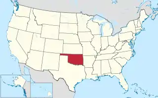 Oklahoma's location within the U.S. | |
| Coordinates: 35°10′N 96°37′W | |
| Country | |
| State | |
| Founded | 1907 |
| Seat | Wewoka |
| Largest city | Seminole |
| Area | |
| • Total | 640 sq mi (1,700 km2) |
| • Land | 633 sq mi (1,640 km2) |
| • Water | 7.6 sq mi (20 km2) 1.2%% |
| Population (2010) | |
| • Total | 25,482 |
| • Estimate (2019) | 24,258 |
| • Density | 40/sq mi (20/km2) |
| Congressional district | 5th |
Seminole County is notable for the Greater Seminole Field, one of the most important oil fields ever found, which is still producing.[3] It extends into nearby counties. In the early years of the oil boom, workers and adventurers flooded into the county, rapidly tripling the population. As oil production later declined, jobs and residents left.
History
Seminole County has been an important part of the Oklahoma and United States petroleum industry for over 80 years. The Greater Seminole Field was one of the most important oil fields ever found and is still producing.[3] Discovered one field after another in 1926, it contained an estimated 822,000,000 barrels (130,700,000 m3) of oil.[4] To group the fields together, the oil companies decided to come up with a name, and this was suggested by Paul Hedrick, oil editor of the Tulsa World. Early oil discoveries in the area were the Wewoka oil field and Cromwell oil field, both discovered in 1923. Then, on 16 July 1926, the Fixico No. 1 well reached the Wilcox sand at 4073 feet, bringing in the Seminole City Field. Located within the Greater Seminole area are 6 of Oklahoma's 22 giant oil fields, including Earlsboro, St. Louis, Seminole, Bowlegs, Little River, and Allen. Total production from the Greater Seminole area from 1926 to 1936 was 702,157,800 barrels, or 18% of all production in Oklahoma.[5]
The Maud field, discovered in 1927 by Amerada Petroleum, was the first discovery using reflection seismology.[6] This marked the beginning of the use of modern geophysical methods in the petroleum industry.
The Seminole County Courthouse was built in 1927.
Geography
According to the U.S. Census Bureau, the county has a total area of 640 square miles (1,700 km2), of which 633 square miles (1,640 km2) is land and 7.6 square miles (20 km2) (1.2%) is water.[7] The county is bounded on the north by the North Canadian River and on the south by the Canadian River.[8]
Adjacent counties
- Okfuskee County (northeast)
- Hughes County (east)
- Pontotoc County (south)
- Pottawatomie County (west)
Demographics
| Historical population | |||
|---|---|---|---|
| Census | Pop. | %± | |
| 1910 | 19,964 | — | |
| 1920 | 23,808 | 19.3% | |
| 1930 | 79,621 | 234.4% | |
| 1940 | 61,201 | −23.1% | |
| 1950 | 40,672 | −33.5% | |
| 1960 | 28,066 | −31.0% | |
| 1970 | 25,144 | −10.4% | |
| 1980 | 27,473 | 9.3% | |
| 1990 | 25,412 | −7.5% | |
| 2000 | 24,894 | −2.0% | |
| 2010 | 25,482 | 2.4% | |
| 2019 (est.) | 24,258 | [9] | −4.8% |
| U.S. Decennial Census[10] 1790-1960[11] 1900-1990[12] 1990-2000[13] 2010-2019[1] | |||

As of the census[14] of 2000, there were 24,894 people, 9,575 households, and 6,788 families residing in the county. The population density was 15/km2 (39/mi2). There were 11,146 housing units at an average density of 7/km2 (18/mi2). The racial makeup of the county was 70.74% White, 5.59% Black or African American, 17.39% Native American, 0.22% Asian, 0.05% Pacific Islander, 0.74% from other races, and 5.28% from two or more races. 2.22% of the population were Hispanic or Latino of any race. 94.7% spoke English, 2.9% Muskogee and 1.7% Spanish as their first language.
There were 9,575 households, out of which 30.70% had children under the age of 18 living with them, 53.30% were married couples living together, 13.30% had a female householder with no husband present, and 29.10% were non-families. 25.90% of all households were made up of individuals, and 13.10% had someone living alone who was 65 years of age or older. The average household size was 2.54 and the average family size was 3.05.
In the county, the population was spread out, with 26.30% under the age of 18, 9.00% from 18 to 24, 24.40% from 25 to 44, 23.40% from 45 to 64, and 16.70% who were 65 years of age or older. The median age was 38 years. For every 100 females there were 93.20 males. For every 100 females age 18 and over, there were 90.00 males.
The median income for a household in the county was $25,568, and the median income for a family was $30,791. Males had a median income of $25,954 versus $18,285 for females. The per capita income for the county was $13,956. About 16.70% of families and 20.80% of the population were below the poverty line, including 28.90% of those under age 18 and 14.40% of those age 65 or over.
Life expectancy and health
Of 3,142 counties in the United States in 2014, the Institute for Health Metrics and Evaluation ranked Seminole County 3,014 in the average life expectancy at birth of male residents and 3,108 in the life expectancy of female residents, the lowest life expectancy of Oklahoma counties and among the lowest life expectancy for all counties. Males in Seminole County lived an average of 70.2 years and females lived an average of 75.4 years compared to the national average for life expectancy of 76.7 for males and 81.5 for females.[15]
In the 1980-2014 period, the average life expectancy in Seminole County for females declined by 0.4 years while male longevity increased by 2.7 years compared to the national average for the same period of an increased life expectancy of 4.0 years for women and 6.7 years for men. Seminole County ranked in the worst performing 10 percent of all counties. High rates of smoking and obesity for both sexes and a low level of physical activity for males appear to be contributing factors to the relatively short life expectancy. [16]
In 2020, the Robert Wood Johnson Foundation ranked Seminole country as 61st (of 77 counties in Oklahoma) in "health outcomes," as measured by length and quality of life.[17]
Politics
| Voter Registration and Party Enrollment as of January 15, 2019[18] | |||||
|---|---|---|---|---|---|
| Party | Number of Voters | Percentage | |||
| Democratic | 5,710 | 47.98% | |||
| Republican | 4,501 | 37.82% | |||
| Others | 1,690 | 14.20% | |||
| Total | 11,901 | 100% | |||
| Year | Republican | Democratic | Third parties |
|---|---|---|---|
| 2016 | 69.8% 5,613 | 25.8% 2,071 | 4.4% 353 |
| 2012 | 65.1% 4,856 | 34.9% 2,600 | |
| 2008 | 65.3% 5,600 | 34.7% 2,977 | |
| 2004 | 60.7% 5,624 | 39.3% 3,648 | |
| 2000 | 51.0% 4,011 | 48.1% 3,783 | 0.9% 72 |
| 1996 | 35.7% 2,935 | 51.3% 4,225 | 13.0% 1,069 |
| 1992 | 31.8% 3,253 | 45.2% 4,624 | 23.1% 2,363 |
| 1988 | 45.0% 4,078 | 54.1% 4,911 | 0.9% 84 |
| 1984 | 59.9% 6,009 | 39.5% 3,957 | 0.6% 64 |
| 1980 | 50.0% 5,067 | 46.6% 4,726 | 3.5% 352 |
| 1976 | 41.5% 4,237 | 57.6% 5,874 | 0.9% 91 |
| 1972 | 70.0% 6,879 | 28.0% 2,746 | 2.0% 199 |
| 1968 | 38.1% 3,711 | 39.9% 3,889 | 22.0% 2,142 |
| 1964 | 35.8% 3,676 | 64.2% 6,582 | |
| 1960 | 56.4% 5,505 | 43.6% 4,256 | |
| 1956 | 47.0% 5,230 | 53.0% 5,897 | |
| 1952 | 48.5% 6,668 | 51.5% 7,076 | |
| 1948 | 29.7% 3,423 | 70.4% 8,122 | |
| 1944 | 39.0% 4,560 | 60.9% 7,116 | 0.1% 16 |
| 1940 | 38.1% 6,880 | 61.8% 11,167 | 0.2% 36 |
| 1936 | 25.4% 4,001 | 74.2% 11,695 | 0.5% 72 |
| 1932 | 21.6% 3,348 | 78.4% 12,154 | |
| 1928 | 64.6% 8,072 | 35.4% 4,423 | |
| 1924 | 40.1% 2,326 | 51.8% 3,007 | 8.2% 475 |
| 1920 | 60.7% 3,382 | 33.6% 1,869 | 5.7% 318 |
| 1916 | 26.8% 872 | 44.4% 1,444 | 28.8% 935 |
| 1912 | 27.0% 715 | 44.3% 1,172 | 28.7% 758 |
References
- "State & County QuickFacts". United States Census Bureau. Retrieved November 13, 2013.
- "Find a County". National Association of Counties. Retrieved June 7, 2011.
- Bobby D. Weaver, "Greater Seminole Field," Encyclopedia of Oklahoma History and Culture, Oklahoma Historical Society, 2009. Accessed April 5, 2015.
- Historical Dictionary of the Petroleum Industry, Appendix 13
- Welsh, Louise; Townes, Willa Mae; Morris, John W. (1981). A History of The Greater Seminole Oil Field. Oklahoma Heritage Association. p. 3-21,56,72. ISBN 0865460310.
- Historical Dictionary of the Petroleum Industry, p. 40
- "2010 Census Gazetteer Files". United States Census Bureau. August 22, 2012. Retrieved February 22, 2015.
- Mullins, William H. "Seminole County," Encyclopedia of Oklahoma History and Culture, Oklahoma Historical Society, 2009. Accessed April 5, 2015.
- "County Population Totals: 2010-2019". Retrieved February 5, 2021.
- "U.S. Decennial Census". United States Census Bureau. Retrieved February 22, 2015.
- "Historical Census Browser". University of Virginia Library. Retrieved February 22, 2015.
- Forstall, Richard L., ed. (March 27, 1995). "Population of Counties by Decennial Census: 1900 to 1990". United States Census Bureau. Retrieved February 22, 2015.
- "Census 2000 PHC-T-4. Ranking Tables for Counties: 1990 and 2000" (PDF). United States Census Bureau. April 2, 2001. Retrieved February 22, 2015.
- "U.S. Census website". United States Census Bureau. Retrieved January 31, 2008.
- "County Profiles: Seminole County, Oklahoma" (PDF). Institute for Health Metrics and Evaluation. University of Washington. Retrieved December 28, 2020.
- "US Health Map". Institute of Health Metrics and Evaulation. University of Washington. Retrieved December 28, 2020.
- "2020 Oklahoma Report". Robert Wood Johnson Foundation. Retrieved December 27, 2020.
- "Oklahoma Registration Statistics by County" (PDF). OK.gov. January 15, 2019. Retrieved February 27, 2019.
- Leip, David. "Dave Leip's Atlas of U.S. Presidential Elections". uselectionatlas.org. Retrieved March 30, 2018.
Places adjacent to Seminole County, Oklahoma | ||||||||||
|---|---|---|---|---|---|---|---|---|---|---|
| ||||||||||
Municipalities and communities of Seminole County, Oklahoma, United States | ||
|---|---|---|
| Cities | Seminole County map | |
| Towns | ||
| Unincorporated communities |
| |
| Indian reservations | ||
| Footnotes | ‡This populated place also has portions in an adjacent county or counties | |
| ||
Oklahoma City (capital) | ||
| Topics |
|  |
| Society |
| |
| Regions | ||
| Largest cities | ||
| Counties |
| |
| Authority control |
|---|