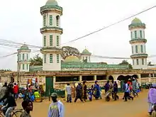
Serekunda
Serekunda (proper: Sayerr Kunda or Sere Kunda, Arabic: سيريكوندا, sometimes spelled Serrekunda) is the largest urban centre in The Gambia.[2] It is situated close to the Atlantic coast, 13 km (8 mi) south-west of the capital, Banjul,[3] and is formed of nine villages which have grown together into a larger urban area.
Serekunda
سيريكوندا | |
|---|---|
City | |
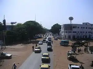 Kairaba Avenue in Latri Kunda, a key suburb of Sere Kunda. | |
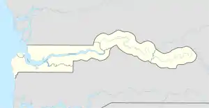 Serekunda Location in the Gambia | |
| Coordinates: 13°26′N 16°40′W | |
| Country | |
| Division | Kanifing |
| Founded by | Sayerr Jobe |
| Named for | Founder |
| Population | |
| • Total | ~ 337,000 |
| Time zone | 0 GMT |
History and toponymy
Sayerr Jobe, the founder of Serekunda, was a 19th-century lamane originally from the Sine-Saloum region of Senegal. He migrated to the Gambia in the mid 19th Century and is believed to have initially settled around Jinack Island in Banjul, before relocating to the southern bank of the country (near Sukuta) where he established Serrekunda.[4]
Serekunda means "home of the Sayer [or Sayerr] family" and is named after its founder, Sayerr Jobe.[3] The name Serrekunda (or "Sere Kunda") is a Mandinka corruption of the name Serrereh — denoting the Serer people in Mandinka, as the Mandinka people of Sabiji believed that Sayerr Jobe (the founder of Sererkunda[4]) and his brother Massamba Koki Jobe/Diop (relative of Lat Dior - King of Cayor and Baol) and the Jobe family in general were members of the wolof ethnic group.[5] Thus, in the oral tradition of the Mandinkas of Sabaji (to which Serekunda was part of), they initially referred to the area with the Mandinka saying: "mbitala serrereh kunda" (I am going to Serer area/country), later shortened to Serreh Kunda (or Serekunda). The word kunda or kundaa is a Mandinka word for place, area, country or compound. In essence, Sere Kunda means Serer country/area made in reference to Sayerr Jobe who was from the Serer Sine-Saloum area, and whom the Mandinkas believed to be of Serer origin.[5] Although born in Serer country, and possessed the Serer title lamane, he was not of Serer origin, but of Lebou origin, as Jobe or Diop is a Lebou surname.
Population history
| 1973 | 1983 | 1993 | 2007 |
|---|---|---|---|
| 25,505 | 70,435 | 194,987 | 348,118 [1] |
Districts or suburbs
The following districts form part of Sererkunda:
- Bakoteh
- Bunungka Kunda
- Dippa Kunda
- Eboe Town
- Faji Kunda
- New Jeshwang
- Old Jeshwang
- Kololi
- Kotu
- Latri Kunda
- Latri Kunda Sabiji
- Manjai Kunda
- Serekunda District
- Talinding Kunjang
- Churchill's Town
Gallery
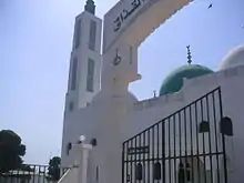
 Mosque on Bundung Highway
References
- "Gambia town information".
- "Introducing Serekunda & the Atlantic Coast". Lonely Planet. Retrieved 29 May 2014.
- "Serrekunda Town, Gambia". Access Gambia. Retrieved 2015-07-15.
- Briggs, Philip; Fenton, Simon; The Gambia, Bradt Travel Guides (2017), p. 103, ISBN 9781784770648
- Sarr, Assan, Islam, Power, and Dependency in the Gambia River Basin: The Politics of Land Control, 1790-1940, Boydell & Brewer (2016), pp. 64–95, 176, ISBN 9781580465694
External links
| Wikimedia Commons has media related to Serekunda. |
| Wikivoyage has a travel guide for Serekunda. |
