Sethiathoppu
Sethiyathope (Tamil: [seːttijaːttoːppɯ]) is a panchayat town in Bhuvanagiri Taluk, Cuddalore district in the Indian state of Tamil Nadu. It is situated on a crossroads of the Chennai-Tanjore (NH-45C) highway. Sethiyathope was established as a civilian town by the Cholas in the 11th century C.E. According to Tamil scholars, Sethiyathope was formed as a settlement when the famous Chola King Rajendra moved his capital from Thanjavur to Gangaikondacholapuram which lies 20 km south.
Sethiyathoppu
Sethiyathope | |
|---|---|
panchayat town | |
| Coordinates: 11.26°N 79.32°E | |
| Country | |
| State | Tamil Nadu |
| District | Cuddalore |
| Government | |
| • President | K.P.D. Elanchezhiyan |
| Area | |
| • Total | 14 km2 (5 sq mi) |
| Population (2011) | |
| • Total | 10,547 |
| Languages | |
| • Official | Tamil |
| Time zone | UTC+5:30 (IST) |
| PIN | 608702 |
| Telephone code | 91-04144 |
| Vehicle registration | TN-91(TN-31 till Jun 17,2015), Now TN -91. |
Sethiyaar, a landlord used to own this piece of woodlands (Thoppu) on the banks of river Vellar and thus derives the name Sethiyarthoppu (Sethiathope). There are close to 60 largely agrarian villages nearby.
Demographics
As of 2001 India census,[1] Sethiyathoppu had a population of 7962. Males constitute 52% of the population and females 48%. Sethiyathoppu has an average literacy rate of 72%, higher than the national average of 59.5%: male literacy is 80%, and female literacy is 64%. In Sethiyathoppu, 10% of the population is under 6 years of age.
Transportation
Road
Sethiyathope lies in National Highway NH 36, connects Vikravandi and Manamadurai. Sethiyathope lies in the main road that connects Kumbakonam and Chennai. It located at a distance of 222 km from Chennai and 60 km from Kumbakonam.
Train
The nearest railway station to Sethiyathope is Vadalur railway station at 16 km. Train to Chennai is available at Chidambaram railway station at 25 km and Virudachalam junction at 31 km.
Nearby cities
- Chidambaram - 19 km distance (30 minutes travel time)
- Virudhachalam - 25 km distance (45 minutes travel time)
- Neyveli - 23 km distance (30 minutes travel time)
- Vadalur - 13 km (20 minutes travel time)
- Srimushnam - 20 km (30 minutes travel time)
- GangaiKonda Cholapuram - 30 km (55 minutes travel time)
- Pichavaram Mangrove Forest - 35 km (1 hour travel time)
- Bhuvanagiri Sri Ragavendra temple - 10 km (15 minutes travel time)
Facilities
There are a primary health centre (GH), police station, and a couple of higher secondary and nursing schools here. There are 15 wards in Sethiyathope Panchayat.
Tourist attractions
Veeranam Lake
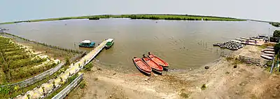
Veeranam Lake, located 2 kilometres south of Sethiathope, is the second-largest lake in the state of Tamil Nadu. The lake, located 235 km from Chennai, India, is one of the important water reservoirs that supplies drinking water to Chennai. Veeranam Lake was created during Chola period in the tenth century, built from 1011 to 1037 AD[3] and is an 16 km (9.9 mi) long dam in northern Tamil Nadu.
===Birthplace of Ramalinga Swamig===Arutprakasa Vallalar Chidambaram Ramalingam (Tamil: அருட்பிரகாச வள்ளலார் சிதம்பரம் இராமலிங்க அடிகள்), (5 October 1823 – 30 January 1874), whose pre-monastic name was Ramalingam, is commonly known in India and across the world[1] as Vallalar (Tamil: வள்ளலார்). He was one of the most famous Tamil saints and also one of the greatest Tamil poets of the 19th century and belongs to a line of Tamil saints known as "Gnana Siddhars" (gnana means higher wisdom). The Suddha Sanmarga Sangam was spread and passed on by him not only in theory but mainly in practice by his own way of living which was itself inspiration for his followers. Through the notion of Suddha Sanmarga Sangam, the saint endeavored to eliminate the menace of caste. According to Suddha Sanmarga, the prime aspects of human life should be love connected with charity and divine practice leading to achievement of pure knowledge.
Ramalinga Adigal was the youngest child of Ramiah Pillai and his sixth wife Chinnamaiar, who lived in Marudur in South Arcot district, a village 7 km north of Sethiyathoppu in the National Highway 45C.
Gangaikonda Cholapuram
Gangaikonda Cholapuram (Tamil: கங்கைகொண்ட சோழபுரம்) was erected as the capital of the Cholas by Rajendra Chola I, the son and successor of Rajaraja Chola, the great Chola who conquered a large area in South India at the beginning of the 11th century C.E. It occupies an important place in the history of India. As the capital of the Cholas from about 1025 C.E. for about 250 years, the city controlled the affairs of the entire south India, from the Tungabhadra in the north to Ceylon in the south. The great temple of Siva at this place is next only to the Brihadisvara temple at Thanjavur in its monumental nature and surpasses it in sculptural quality.
Gangaikonda Cholapuram is located 15 km south of Sethiathoppu on the National Highway 45C. Gangaikonda Cholapuram can be reached by taxi and bus from Sethiathoppu.
Birthplace of Raghavendra Swami
Sri Guru Raghavendra Swamy (1595–1671) is an influential 16th-century Hindu saint who advocated Vaishnavism (worship of Vishnu as the supreme God) and Sri Madhvacharya's Dvaita philosophy. He ascended Brindavana at Mantralayam in present-day Andhra Pradesh in 1671. Sri Raghavendra Swami was born as Sri Venkanna Bhatta, the second son of Sri Thimanna Bhatta and Smt. Gopikamba on Thursday, Sukla Saptami of Phalguna month in 1595, when the moon was in Mrigashirisha Nakshatra, at Bhuvanagiri, near present-day Chidambaram in Tamil Nadu.
Bhuvanagiri is about 11 kilometers east of Sethiathoppu on the National Highway 227. Bhuvanagiri can also be reached from Sethiathoppu by State Highway 70.
Nataraja Temple, Chidambaram
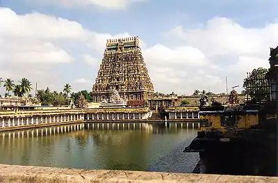
The ancient Chidambaram Temple (Tamil: சிதம்பரம் கோயில் ) is dedicated to Lord Shiva in His form of the Cosmic Dancer (Nataraja நடராசர்). It is one of the five Dancing Halls (Sabha) of Nataraja and the most famous one. Chidambaram hosts the most ancient set of 108 Karana stone carvings, the key dance movements of Nataraja. The temple complex is spread over 40 acres (160,000 m2) in the heart of the city. Many thousands of devotees come to this auspicious temple to pay homage to the Dancing Siva. Chidambaram is in the Kollidam River valley about 11 km from the Bay-of-Bengal coast, 20 km east of Sethiathoppu in NH 227 and 240 km south of Chennai by rail.
Pichavaram Mangrove Forest
Pichavaram the second largest mangrove forest in the world, near the temple town of Chidambaram, is one of the unique eco-tourism spots in South India. The backwaters, inter connected by the Vellar and Coleroon river systems, offer abundant scope for water sports, rowing, kayaking and canoeing. Pichavaram mangroves are considered among the healthiest mangrove occurrence in the world. Pichavaram consists of a number of islands interspersing a vast expanse of water covered with green trees. The area is about 2,800 acres (11 km2) and is separated from the sea by a sand bar which is a patch of extraordinary loveliness. Pitchavaram is located on the Bay-of-Bengal coast about 20 km east of Sethiathoppu.
Nearby villages
- Agaram Alambadi : This village is located just 8km west from Sethiyathope town. This village is surrounded by farm lands and it's very greenish place.There is a Sivan temple in that village named as Vedhambikai sametha Vedhapurishwarar. Other temples like Vinayagar temple,Mariamman temple,Selliyamman temple, Sanniyasiappar temple,Iyyappan temple and Anjanayar temples are there in that village.The main business is agriculture and the main cultivation is sugarcane and paddy . South border of that village, Vellar river is located. One primary school is there in that village.
- Muganthariyan Kuppam
- Madhuvanaimedu, this village's people are based to Vanniya Kulla Kshatriyar family. The great Vinnayagar temple, Sri Throwpati Amman Kovil, Veeranaar Kovil, Iyyannar temple, then biggest lake water store for 500 acres and all are depending upon agriculture its natural village.
- Allur: This village is near Sethiyathope. Here Maha Sakthi Mariyamman kovil is famous.
- Senninatham Arulmigu Padariamman Temple is near government hospital
- Anaivari, Cuddalore: This village is 2 kilometres from Sethiyathope. It is agriculture dependent village. Main cultivating is sugarcane and paddy. Here placed one of the famous KaliAmman kovil in Anaivari Mattu street.
- North Senninatham, which is near Sethiyathope. Arulmigu Sree Madhurakaaliyamman temple is there.
- Periyanarkunam: This village is 5 km from Sethiyathope, here Kalli Amman kovil, Chithra Powrnami festival are famous, every month Powrnami day in around from Tamil Nadu, people come for Kuri.
- Paripoorananatham
- Chinnanarkunam
- Boothangudi
- Maduranthaga Nallur
- CinnaKuppam
- Veeramudaiyanatham
- Vattathur
- Solatharam - an agricultural village
- Erumbur
- PeriyaKuppam - This village is nearby Sethiyathope. Here Mariyamman kovil is famous. Well educated and decent village. It is an agriculture village.
- Cinna Kuppam
- Pinnalur
- Miralur
- Kilangadu
- C. Sathamangalam
- Parathur Savadi
- Kilavadinatham
- Kanur
- Perur
- Valayamadevi
- Mazhavarayannallur
- Kumarakudi
- Kothandavilakam
Nearby hospitals
- Govt. Health Centre (Senninatham)
- Jagathiru Hospital (scan, ECG, laboratory attached)
- Varma Poly-Clinic
- Annamalai Medical College Hospital (20 km SE)
- JIPMER, Pondicherry (70 km NE)
- SCR Hospital (general and diabetes)
- Solatharam Aarthi Telecoom
- Amsa Hospital (Sethiyathope)
- Krishna hospital Cuddalore (multi-speciality hospital)
- Krishna cancer institute, Cuddalore (oncology)
Schools
- DGM (Devangudi Gopalakrishna Mazhavarayar) Higher Secondary School (govt.-aided Tamil medium and self-financed English medium)
- Punchayat Union Middle School (Sethiathope)
- Punchayat Union Elementary School (Periyakuppam)
- R.C. Middle School, Thandeswaranallur
- GOVT Hr Sec School, Kanur
- R.C Primary School, Kanur
- DGM Nursery Primary School (Sethiathope)
- Punchayat Union Elementary School (Sennintham)
- Punchayat Union Primary School (North Senninatham)
- Chandira Hr. Sec. School Senninatham
- S.D.S, Matriculation School
- Mano Vidhyalaya Matriculation School (Murugan Koil Street)
- Arul Nursery and Primary School
- S.D. Eden school (X Road)
- Thiruvalluvar Hr. Secondary school (Orathur)
Temples
- Arulmighu Ayyanar Thirukkoil, Miralur.
- Pillaiyar Kovil, Muganthariyan Kuppam
- Maha Sakthi Mariyamman Temple, Allur
- Pedariamman Temple Senninatham
- Sree Kaali Amman Temple, Periyanarkunam, Powrnami festival every month
- Arulmigu Selliyamman Temple (Kanur)
- Arulmigu Madhurakaaliyamman Temple (North Senninatham)
- Sree TheePaindha Naachiyar Amman Temple (Budhangudi - on Kumbakonam Highway)
- Arulmigu Kaaliyamman Temple (Anaivari)
- Pidariyamman Temples (Senninatham, X-Road)
- Sree Ramalingeshwar Aalayam' (Pinnalur)
- Vazhmuni Amman Temple (Maduranthaga Nallur)
- Sree Pavadairayan Temple (Maduranthaga Nallur)
- Sree Varasidhi Vinayagar Aalayam (Sethiathope, opposite to Maniam Cloth Stores and Readymades)
- Arulmigu Paavadairayar Temple, Erimedu, Budhangudi Kumbabhishegam
- Arulmigu Periyaandavar-Periyanayagi Temple within A/M Paavadairayar Temple Budhangudi
- Ayyanar Temple, Kizhakku Theru, Buhangudi (an ancient Poorna Pushkala samedha Ayyanar stone sculpture deity for which new temple Kumbabhishegam performed on 19-04-2010)
- Sivan Temple (X-Road)
Boothangudi is another village close to Sethiyathoppu. In fact Arulmigu Theepaindha Nachiyar temple is in revenue limits of Boothangudi only. Recently Paavadairayan temple, Periyanayagi-Periyandavar Temple and Ayyanar temples have been newly constructed in Boothangudi and Kumbabishegam performed on 19 April 2010.
Sethiyathope Anicut
Sethiyathope anicut was constructed in 1851 during the colonial period. This anicut was one of the oldest anicut in Tamil Nadu. This anicut was constructed on Vellar river, from this anicut many villages obtain revenue for their agriculture. In this river Vellar, the Veeranam Lake water also merges, from this river Sellar water flows to X-Road of Sethiyathope, Pinnalur, Karaimedu, Maruvai, Kolakudi, Boddampadi then reach entrance of Perumal lake near Kurinjipadi and Kullanchavadi a distance of 8km. On Maruvai the river's name was Paravanaaru River Bank.
Veeranam lake
Veeranam lake birth from Cauvery river place of Kollidam river lower anicut. Veeranam Lake was built in the Tenth century during the time of Greater Cholas, from 907–955 AD[1] and is a 16-kilometre (9.9 mi) long dam in northern Tamil Nadu. It was created by Rajaditya Chola. He named it after his father Parantaka I Chola, who had the title "Veeranarayanan". Veera Narayanapuram modified into Veeranam over time. Veeranam lake gets water from Kollidam via Vadavaru River. The lake remains dry for the major part of the year. Water released from the Mettur dam through Kollidam and Lower Anicut would also bring in sufficient inflow into the Veeranam Lake. The lake received sufficient inflow in April enabling supply to the city for three months. With heavy rain in Western Ghats, the lake almost got its storage capacity as it received inflow from the Cauvery tributaries Bhavani and Amaravathi.
The Veeranam Project
The Veeranam project,[3] to supply water to Chennai, was conceived in 1967 by the then Chief Minister of Tamil Nadu, C. N. Annadurai, and executed under his successor, M. Karunanidhi. The project was subject to rampant corruption and money earmarked for the project was lost, leading to stagnation of the project. The project's completion in 2004 by the then Chief Minister of Tamil Nadu, J. Jayalalitha. It was impossible to use any water from the lake since it had run dry, and the face-saving proposal adopted by the authorities was to dig 45 deep borewells around the area and pump the resulting water 235 km (146 mi) to Chennai via the pipeline.[4] The length of the lake is 14 km and this is the largest lake in Tamil Nadu. The credit goes to ancient people who have done this job with ordinary hand-made tools.
Perumal lake
Perumal Aeri's irrigation covers around 1000 acres of agricultural land. Villages include Puduchatram, Alapakkam, Theerthanagiri, Thaanur, Samba Reddy Palayam, Aayi Thurai, Mettu Palayam, Pundiaan Kuppam, T. Kalaiyan Kuppan, and Kundiyamallur Aathi Narayanapuram. Overflow water is let through a channel to Sangolikuppam river.
References
- "Census of India 2001: Data from the 2001 Census, including cities, villages and towns (Provisional)". Census Commission of India. Archived from the original on 16 June 2004. Retrieved 1 November 2008.
2.http://www.townpanchayat.in/sethiyathope
| District headquarters |  | |
|---|---|---|
| Country | ||
| State | ||
| Region | ||
| Taluks |
| |
| Blocks | ||
| Municipalities | ||
| Rivers | ||
| Lakes | ||
| History | ||
| Places of interest | ||
| Universities | ||
