Sgùrr nan Ceathramhnan
Sgùrr nan Ceathreamhnan is a Scottish mountain that is situated in the remote and lonely mountainous country between Glen Affric and Glen Elchaig, some 30 kilometres east of Kyle of Lochalsh in the Highland region. With a height of 1151 metres (3776 feet) it is ranked as the third highest mountain north of the Great Glen (after Carn Eighe and Mam Sodhail) and is regarded as one of the finest hills in the whole of the United Kingdom. It is different from the other neighbouring Affric Hills, characterised by sweeping flanks and long slender ridges, which emerge from the central summit crest in the manner of the spokes of a wheel.
| Sgùrr nan Ceathreamhnan | |
|---|---|
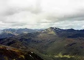 Sgùrr nan Ceathreamhnan from Mam Sodhail, 5 km to the NE. The Kintail hills are in the background | |
| Highest point | |
| Elevation | 1,151 m (3,776 ft) [1] |
| Prominence | c. 435 m |
| Listing | Munro, Marilyn |
| Naming | |
| English translation | Peak of the Quarters |
| Language of name | from Gaelic Sgùrr nan Ceathramhan |
| Pronunciation | Scottish Gaelic: [ˈs̪kuːrˠ nəŋʲ ˈkʰʲɛɾəvən] |
| Geography | |
| Location | Glen Affric, Scotland |
| Parent range | Northwest Highlands |
| OS grid | NH056228 |
| Topo map | OS Landranger 25, 33 |
| Listed summits of Sgùrr nan Ceathramhnan | ||||
| Name | Grid ref | Height | Status | |
|---|---|---|---|---|
| Western Top | NH052228 | 1143 m (3750 ft) | Munro Top | |
| Stùc Bheag | NH053237 | 1075 m (3527 ft) | Munro Top | |
| Stùc Mòr | NH053242 | 1041 m (3415 ft) | Munro Top | |
| Stob Fraoch Choire | NH052253 | 918 m (3012 ft) | Munro Top | |
| Stob Coire na Cloiche | NH075227 | 915 m (3002 ft) | Munro Top | |
Geography
Sgùrr nan Ceathreamhnan is rated as one of the remotest Munros and a great prize for any hill walker, with E.J. Yeaman in his Handbook of the Scottish Hills regarding Ceathreamhnan as the fourth most difficult Scottish Munro to climb, taking into account its remote position and its altitude. It is a massive mountain which covers 24 square miles (62 square km) and stands many kilometres from the nearest public road, it has a tent like appearance and throws down many long ridges to the valleys. It has five subsidiary “tops”, three of these stand on the northern ridge, they are Stuc Bheag (1075 metres), Stuc Mòr (1041 metres) and Stob Fraoch Choire (918 metres). The Western Top (1143 metres) is also regarded as a "top" as is Stob Coire na Cloiche (915 metres) on the eastern ridge. In addition to this Sgùrr nan Ceathreamhnan has three tops which have been deleted from the list over the years, making a total of eight distinct summits on the mountain in addition to the highest point. Its outlier to the north east, Mullach na Dheiragain, is regarded as a separate Munro.
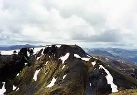
Sgùrr nan Ceathreamhnan’s name looks notoriously difficult to pronounce for non Gaelic speakers and is often facetiously referred to as "Chrysanthemum" by hill walkers who do not know Gaelic. The English translation from the Gaelic name is "Peak of the Quarters" referring to the large amount of land it divides with its ridges. Sgùrr nan Ceathreamhnan’s summit has twin peaks linked by a curving ridge with the western pinnacle lying 500 metres away from the highest point and reaching 1143 metres in height. There is a small amount of scrambling involved in traversing between the two summits.
Ascents
The ascent of Sgùrr nan Ceathreamhnan is a major undertaking best done during the long hours of summer daylight. The shortest approach is from the Alltbeithe youth hostel in upper Glen Affric at grid reference NH079202 3.5 kilometres south of the summit; however, it is a major undertaking just to get to the hostel, with long walks in from Loch Cluanie to the south or from the road end in Glen Affric. It is also possible to start walking from Iron Lodge in Glen Elchaig but a bicycle is needed to travel up the estate road, another approach starts from the car park in Strath Croe. From the Alltbeithe hostel the ascent goes north up a stalkers path to the col between Sgùrr nan Ceathreamhnan and An Socach - the latter a minor Munro which can be easily "bagged" on the way to Ceathreamhnan’s summit with little extra effort. The view from the summit is one of remote mountainous country, although with the help of binoculars it is possible to see Inverness and the Kessock Bridge, over 70 kilometres away to the east.
References
Footnotes
- "walkhighlands Sgurr nan Ceathreamhnan". walkhighlands.co.uk. 2014. Retrieved 9 January 2014.
 |
|  | |
List of Munros | |||