ShakeAlert
ShakeAlert is an earthquake early warning system (EEW) for the West Coast of the United States and the Pacific Northwest sponsored by the United States Geological Survey (USGS).[1][2]
The system uses sensors to detect P waves, compressional primary waves created by earthquakes and traveling faster than the damaging S waves. ShakeAlert is currently in a demonstration phase and has been sending real-time alerts to selected beta users since January 2012.[1] The system will issue automated alerts to give people time to take protective actions like "drop, cover and hold on" in the event of a quake, preventing injuries caused by falling debris, automatically stopping public transport systems, preventing cars from entering bridges or tunnels, automatically shutting down industrial systems and gas lines, and triggering specific protocols in hospitals and other sensitive work environments. Initially the system will cover the west coast of North America which is exposed to significant seismic risk along the San Andreas fault zone or the Cascadia subduction zone.
The second algorithm crucial to ShakeAlert is the - Onsite algorithm.[3] By using displacement amplitude and period of the first signs of shaking, this onsite algorithm more accurately predicts the intensity and size of the earthquake than the ElarmS do.[4] The tradeoff for using these algorithms for the earliest detection possible means having a less reliable approach than regional warning algorithms, however some argue that the added seconds to prepare are more important than reliability. Lastly, the Virtual Seismologist, as known as the VS method, imitates the analysis of a human scientist in terms of capacity, but does so at a faster rate. A Bayesian framework is used with inputs of acceleration, velocity, and displacement.[4] The last step requires of all these algorithms to come together in a decision module. This decision module broadcasts the probability, size, and other characteristics of the earthquake.


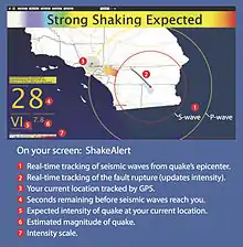
The ShakeAlert system alerts the surrounding populations of an earthquake that has already happened. When the system detects the earthquake, the first step is to release several horn noises at a high volume level. Next, an automated voice says the word "earthquake". The shaking that follows can start after varying intervals of time- anywhere from a couple seconds to several minutes. The purpose of then ShakeAlert system is not to predict an earthquake before it happens, but instead to determine and locate the earthquake as soon as it begins to happen. Within a single second, ShakeAlert can detect the location and severity of the earthquake to warn people of its presence. The people who these type of signals reach can vary. In the state of California, where earthquakes happen quite often, some of those most important listeners of this system include the Bay area's rapid transit system (BART).[5] Other important organizations that need to know the early onset of earthquakes are Fire Departments all along the west coast, as well as places like Disneyland, where a large population of people is limited to a relatively small geographical space. BART is already directly connected to the ShakeAlert system, so if the system were to send out early warnings of an earthquake, the metro system will automatically pause and adjust its trains to prevent serious accidents or derailments. Doug Given, one of the main leaders of the project, also serves as the National Earthquake Early Warning Coordinator for the U.S. Geological Survey.[6] He explains in an interview with National Public Radio, the way in which the system is designed to alert the public. He explains that the system plans to reach populations in a similar way that the public receives Amber alerts.
Performance
The ShakeAlert system issued alerts for several significant southern California earthquakes in 2014 including a M4.4 event in Encino, a M4.2 event in Westwood, and a M5.1 event in La Habra.[7]
ShakeAlert issued a warning 5.4 seconds after the beginning of the 6.0 magnitude earthquake that hit the Napa region on August 24, 2014.[8] Although it was initially reported that the system provided 10 seconds of warning before the S-wave arrived in Berkeley,[9][10] subsequent information showed that this was in error and the warning arrived only 5 seconds before the S-wave in Berkeley.[8] This means the S-waves had already arrived in Napa and Vallejo when the warning was issued. San Francisco received 8 seconds warning.[7]
In the 4 July 2019 M6.4 and 5 July M7.1 Ridgecrest earthquakes, Early Warning Labs became the first and only commercially licensed USGS partner to successfully deliver ShakeAlerts to people & automated systems across Southern California.[11] Early Warning Labs consumer app QuakeAlert, was the only app to successfully deliver mobile alerts. The average user warning for both earthquakes was 45 seconds.[12]
A variant of the system, called ShakeAlertLA, did not activate during the 2019 Ridgecrest earthquake, with seismologists reporting that the system detected the earthquake but did not send out alert messages.[13] According to the City of Los Angeles, the system did not send alerts due to the earthquake being below the activation threshold, which is set at 5 MW in the Los Angeles area. However, Caltech did receive a warning 48 seconds before the quake struck.
Participants, funding, and technology
The project is being developed by a consortium of institutions including the United States Geological Survey, the California Governor's Office of Emergency Services (Cal OES), the California Geological Survey, California Institute of Technology, the Berkeley Seismological Laboratory at University of California Berkeley, University of Washington, University of Oregon, and the Swiss Federal Institute of Technology in Zurich (ETHZ). The Gordon and Betty Moore Foundation has invested more than $6 million in developing the system.[14]
USGS estimates the west coast system will cost $38 million to complete and $16 million per year to operate over and above the investment that is already made in earthquake monitoring.[2] More than 30 Congress members have signed a joint letter urging the President to add full funding for the system to his federal budget request.[15]
ShakeAlert warnings will be sent out via cell phones, television, radio, and even may be implemented into large buildings and malls. ShakeAlert is capable of detecting earthquakes at an early stage because of three specific algorithms. The first algorithm is ElarmS.[4] Also known as Earthquake Alarm Systems, these signals detect the P-wave energy released from any given earthquake. This energy, while given off quite early, does not usually cause damage. It is also the ElarmS that are responsible for roughly estimating the geographical location and size of the earthquake. Following these Elarms, empirical attenuation relations estimate how much the earth will shake in the specified region of the quake.
In December 2014, $5 million was added to the USGS budget for ShakeAlert development.[16] This enabled USGS to purchase $1 million in seismic instrumentation and award $4 million in funding to the project partners to make current "ShakeAlert" demonstration system more robust.[17][18][19][20] As of August 2015, organizations enrolled in the beta test user program include: CalOES Warning Center, LA County Fire, LA City OEM, Amgen Corp, LADWP, Metrolink, Caltrans and Disneyland.[21]
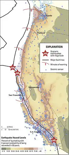
The West Coast of the United States is vulnerable to seismic activity. From California to Washington, constant plate movement is detected by both strong motion and broadband stations located throughout these states. EEW systems across the world have proven that an alert sent out 10 to 20 second before strong shaking starts has the potential to save millions of lives and prevent disasters from train derailment to natural gas explosions.
Currently, the United States Geological Survey (USGS) along with the University of California Berkeley (UCB), California Institute of Technology (Caltech), the University of Washington (UW), and the University of Oregon (UO) are developing and testing their version of an EEW system, ShakeAlert. However, the Trump administration has slashed the budget for the earthquake hazard program, which will affect the continued progress of ShakeAlert. State funds are available, but the program would likely benefit from federal funding to expand the current array to cover areas along the West Coast that are lacking seismic stations.
In October 2019, on the thirtieth anniversary of the Loma Prieta earthquake, CalOES announced a statewide rollout of the ShakeAlert system. The alerts are transmitted via a free mobile app by UC Berkeley, MyShake (for magnitude 4.5 with seismic intensity 3 and higher), and the existing Wireless Emergency Alert System (for magnitude 5.0 with seismic intensity 4 and higher).[22][23][24]
In December 2019, the earthquake early warning system issued its first public ShakeAlert for a 4.3 earthquake in the Cholame Valley. The warning was transmitted through a smartphone app, MyShake, because preliminary readings measured the magnitude as 4.8. No Wireless Emergency Alerts were transmitted because the magnitude of the earthquake was below the 5.0 threshold.[25]
User Display
The User Display interprets the results of the Decision Module and rearranges the information into more user-friendly terms for the ordinary person.[26] Some of the things that this User Display will include is:
- "display of estimated magnitude"
- "display of the probability of correct alarm"
- "siren and audio announcement"
- "calculation and display of remaining warning time for a given user"
See also
References
- Burkett, Erin R.; Given, Douglas D.; Jones, Lucile M. (2014-01-01). "ShakeAlert: an earthquake early warning system for the United States West Coast". U.S. Geological Survey Fact Sheet 2014–3083. Fact Sheet: 4. doi:10.3133/fs20143083.
- Given, D.D; Cochran, E.S.; Heaton, T.; Hauksson, E.; Vidale, J.; Bodin, P. (May 12, 2014). "Technical Implementation Plan for the ShakeAlert Production System—An Earthquake Early Warning System for the West Coast of the United States". U.S. Geological Survey Open File Report. Open-File Report. doi:10.3133/ofr20141097. Retrieved 2015-10-24.
- Böse, M.; Hauksson, Egill; Solanki, K.; Kanamori, H; Heaton, T.H. (2009). "Real-time testing of the on-site warning algorithm in southern California and its performance during the July 29 2008 Mw5.4 Chino Hills earthquake" (PDF). Geophysical Research Letters. 36 (5): L00B03. Bibcode:2009GeoRL..36.0B03B. doi:10.1029/2008GL036366.
- Allen. "ShakeAlert". Retrieved October 2015. Check date values in:
|accessdate=(help) - Lin II, Rong-Gong (2020-08-11). "Google adds California's earthquake early warning system into Android phones". Los Angeles Times. Retrieved 2020-08-12.
- Wenzel, F (2013). Early Warning for Geological Disasters: Scientific Methods and Current Practice. ISBN 9783642122323.
- Xia, Rosanna (2014-11-23). "Earthquake early alert system ready to expand in California". Los Angeles Times.
- Allen, Richard M.; Given, Douglas D.; Heaton, Thomas H.; Vidale, John E. (2014). "Successful ShakeAlert Performance for the Napa Quake". 2014 AGU Fall Meeting. San Francisco, CA. 2014 (S44D–01): S44D–01. Bibcode:2014AGUFM.S44D..01A.
- "Experimental warning system gave 10-second alert before California earthquake". CBS News. 2014-08-24. Archived from the original on 25 August 2014.
- Block, Melissa. "In Latest Calif. Earthquake, Shake Alert Tests Its Legs". NPR. Retrieved 2015-08-23.
- "Early Warning Labs Delivers the Only Commercially Licensed ShakeAlerts to People & Automated Systems Across Southern California during Recent M6.4 & M7.1 Earthquakes".
- "Two large earthquakes rattle LA—but where was the early warning?". 2019-07-04.
- Dowd, Katie; SFGATE (2019-07-04). "ShakeAlert fails to send earthquake warning for big SoCal quake". SFGate. Retrieved 2019-07-04.
- "Earthquake Early-Warning System". Moore Foundation. Retrieved 2015-10-24.
- Lin, Rong-gong (2015-03-25). "Congress members urge $16 million to fund quake early warning system". Los Angeles Times. Retrieved 2015-10-24.
- Totten, Sanden (2014-12-15). "California gets $5 million in funding for quake warning system". KPCC.
- "Earthquake early warning system moves closer to reality". 2015-07-31. Retrieved 2015-08-23.
- "USGS Release: USGS Awards $4 Million to Support Earthquake Early Warning System in California and Pacific Northwest (7/30/2015 12:00:00 PM)". www.usgs.gov. Retrieved 2015-08-23.
- Jardin, Xeni (2015-07-30). "Earthquake early warning system gets a $4 million boost from USGS". Boing Boing. Retrieved 2015-08-23.
- "Earthquake early-warning system gets a $4 million boost". SFGate. 2015-07-30. Retrieved 2015-08-23.
- "ShakeAlert Test Users » ShakeAlert". www.shakealert.org. Retrieved 2015-08-23.
- Snibbe, Kurt (2019-10-15). "California's earthquake early warning system is now statewide". Mercury News. Retrieved 2019-12-31.
- Calma, Justine (2019-10-17). "California's earthquake warning app: how it works and what comes next". The Verge. Retrieved 2019-12-31.
- "Wireless Emergency Alerts". ca.gov. Retrieved 2019-12-31.
- "A milestone: Earthquake early warning system sends first public alert to smartphones in California". Los Angeles Times. 2019-12-18. Retrieved 2020-01-08.
- Wenzel, Frank (2013). Early Warning for Geological Disasters: Scientific Methods and Current Practice.
