Sharpsburg, Kentucky
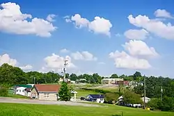
Sharpsburg is a home rule-class city in Bath County, Kentucky, in the United States. The population was 323 as of the 2010 U.S. census.[5] It is part of the Mount Sterling micropolitan area.
Sharpsburg, Kentucky | |
|---|---|
 Sharpsburg | |
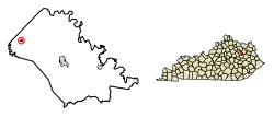 Location of Sharpsburg in Bath County, Kentucky. | |
| Coordinates: 38°12′5″N 83°55′49″W | |
| Country | United States |
| State | Kentucky |
| County | Bath |
| Established | 1825[1] |
| Incorporated | 1852[1] |
| Named for | a local landowner[2] |
| Government | |
| • Type | Mayor and City Commissioners |
| • Mayor | Dorothy C. Clemons |
| Area | |
| • Total | 0.20 sq mi (0.51 km2) |
| • Land | 0.20 sq mi (0.51 km2) |
| • Water | 0.00 sq mi (0.00 km2) |
| Elevation | 1,010 ft (308 m) |
| Population (2010) | |
| • Total | 323 |
| • Estimate (2019)[4] | 338 |
| • Density | 1,715.74/sq mi (662.39/km2) |
| Time zone | UTC-5 (Eastern (EST)) |
| • Summer (DST) | UTC-4 (EDT) |
| ZIP code | 40374 |
| Area code(s) | 606 |
| FIPS code | 21-69852 |
| GNIS feature ID | 0503267 |
History
Revolutionary War veteran Moses Sharp settled in the area in 1780 and laid out the town of Bloomfield on his land in 1814. After his death in 1820, the town received its first post office; since "Bloomfield" was preempted by another community, the postmaster named his station after Sharp, and the town was established and incorporated under this new name.[2]
Geography
Sharpsburg is located near the western corner of Bath County at 38°12′5″N 83°55′49″W (38.201421, -83.930164),[6] along Kentucky Route 11. It is 11 miles (18 km) north of Mount Sterling and 20 miles (32 km) southwest of Flemingsburg. According to the United States Census Bureau, the city has a total area of 0.2 square miles (0.52 km2), all of it land.
Demographics
| Historical population | |||
|---|---|---|---|
| Census | Pop. | %± | |
| 1830 | 158 | — | |
| 1870 | 319 | — | |
| 1880 | 356 | 11.6% | |
| 1890 | 516 | 44.9% | |
| 1900 | 482 | −6.6% | |
| 1910 | 410 | −14.9% | |
| 1920 | 363 | −11.5% | |
| 1930 | 408 | 12.4% | |
| 1940 | 472 | 15.7% | |
| 1950 | 405 | −14.2% | |
| 1960 | 311 | −23.2% | |
| 1970 | 307 | −1.3% | |
| 1980 | 339 | 10.4% | |
| 1990 | 315 | −7.1% | |
| 2000 | 295 | −6.3% | |
| 2010 | 323 | 9.5% | |
| 2019 (est.) | 338 | [4] | 4.6% |
| U.S. Decennial Census[7] | |||
As of the census[8] of 2000, there were 295 people, 149 households, and 77 families residing in the city. The population density was 1,559.6 people per square mile (599.5/km2). There were 154 housing units at an average density of 814.2 per square mile (312.9/km2). The racial makeup of the city was 76.61% White, 20.00% African American, 1.69% from other races, and 1.69% from two or more races. Hispanic or Latino of any race were 1.69% of the population.
There were 149 households, out of which 16.1% had children under the age of 18 living with them, 39.6% were married couples living together, 10.1% had a female householder with no husband present, and 48.3% were non-families. 46.3% of all households were made up of individuals, and 29.5% had someone living alone who was 65 years of age or older. The average household size was 1.98 and the average family size was 2.71.
In the city, the population was spread out, with 16.9% under the age of 18, 7.1% from 18 to 24, 24.4% from 25 to 44, 25.1% from 45 to 64, and 26.4% who were 65 years of age or older. The median age was 46 years. For every 100 females, there were 82.1 males. For every 100 females age 18 and over, there were 85.6 males.
The median income for a household in the city was $16,000, and the median income for a family was $23,750. Males had a median income of $22,188 versus $20,000 for females. The per capita income for the city was $12,452. About 26.7% of families and 32.7% of the population were below the poverty line, including 37.3% of those under the age of eighteen and 35.1% of those 65 or over.
Education
Sharpsburg has a public library, a branch of the Bath County Memorial Library.[9]
Notable people
- Henry Tureman Allen, WWI general
- Henry Smith Lane, governor of Indiana
- Dorothy Corrine Clemons née Johnson, first African-American mayor of Sharpsburg and Bath County
References
- Commonwealth of Kentucky. Office of the Secretary of State. Land Office. "Sharpsburg, Kentucky". Accessed 26 August 2013.
- Rennick, Robert. Kentucky Place Names. University Press of Kentucky (Lexington), 1987.
- "2019 U.S. Gazetteer Files". United States Census Bureau. Retrieved July 24, 2020.
- "Population and Housing Unit Estimates". United States Census Bureau. May 24, 2020. Retrieved May 27, 2020.
- "Geographic Identifiers: 2010 Demographic Profile Data (G001): Sharpsburg city, Kentucky". U.S. Census Bureau, American Factfinder. Archived from the original on February 12, 2020. Retrieved November 19, 2013.
- "US Gazetteer files: 2010, 2000, and 1990". United States Census Bureau. 2011-02-12. Retrieved 2011-04-23.
- "Census of Population and Housing". Census.gov. Retrieved June 4, 2015.
- "U.S. Census website". United States Census Bureau. Retrieved 2008-01-31.
- "Kentucky Public Library Directory". Kentucky Department for Libraries and Archives. Archived from the original on 11 January 2019. Retrieved 5 June 2019.
External links
 Media related to Sharpsburg, Kentucky at Wikimedia Commons
Municipalities and communities of Bath County, Kentucky, United States | ||
|---|---|---|
| Cities | 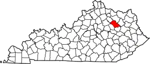 Location of Bath County, Kentucky | |
| Unincorporated communities | ||
| ||
