Sharpsville, Pennsylvania
Sharpsville is a borough in Mercer County, Pennsylvania, United States, along the Shenango River. The population was 4,415 at the 2010 census. It is part of the Youngstown-Warren-Boardman, OH-PA Metropolitan Statistical Area.
Sharpsville, Pennsylvania | |
|---|---|
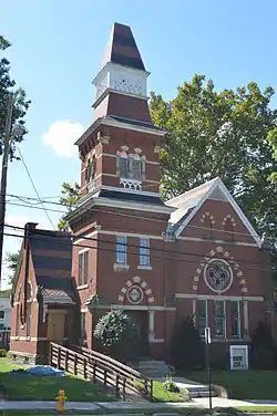 First Universalist Church, a historic site in the borough | |
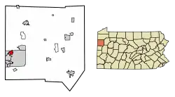 Location of Sharpsville in Mercer County, Pennsylvania. | |
 Sharpsville, Pennsylvania Location of Sharpsville within Pennsylvania | |
| Coordinates: 41°15′32″N 80°28′54″W | |
| Country | United States |
| State | Pennsylvania |
| County | Mercer |
| Established | 1874 |
| Government | |
| • Mayor | Alexander Kovach |
| Area | |
| • Total | 1.40 sq mi (3.63 km2) |
| • Land | 1.39 sq mi (3.60 km2) |
| • Water | 0.01 sq mi (0.03 km2) |
| Elevation [2] (center of borough) | 1,000 ft (300 m) |
| Highest elevation [2] (southeast corner of borough) | 1,140 ft (350 m) |
| Lowest elevation | 870 ft (270 m) |
| Population (2010) | |
| • Total | 4,415 |
| • Estimate (2019)[3] | 4,074 |
| • Density | 2,928.83/sq mi (1,130.82/km2) |
| Time zone | UTC-4 (EST) |
| • Summer (DST) | UTC-5 (EDT) |
| Zip code | 16150 |
| Area code(s) | 724 |
| Website | www.sharpsville.org |
History
The First Universalist Church of Sharpsville and Jonas J. Pierce House are listed on the National Register of Historic Places.[4]
Geography
Sharpsville is located at 41°15′32″N 80°28′54″W (41.259005, -80.481791).[5]
According to the United States Census Bureau, the borough has a total area of 1.4 square miles (3.6 km2), of which 1.4 square miles (3.6 km2) is land and 0.04 square miles (0.10 km2) (1.42%) is water.
Demographics
| Historical population | |||
|---|---|---|---|
| Census | Pop. | %± | |
| 1880 | 1,824 | — | |
| 1890 | 2,330 | 27.7% | |
| 1900 | 2,970 | 27.5% | |
| 1910 | 3,634 | 22.4% | |
| 1920 | 4,674 | 28.6% | |
| 1930 | 5,194 | 11.1% | |
| 1940 | 5,129 | −1.3% | |
| 1950 | 5,414 | 5.6% | |
| 1960 | 6,061 | 12.0% | |
| 1970 | 6,126 | 1.1% | |
| 1980 | 5,375 | −12.3% | |
| 1990 | 4,729 | −12.0% | |
| 2000 | 4,500 | −4.8% | |
| 2010 | 4,415 | −1.9% | |
| 2019 (est.) | 4,074 | [3] | −7.7% |
| Sources:[6][7][8] | |||
As of the census[7] of 2000, there were 4,500 people, 1,912 households and 1,263 families residing in the borough. The population density was 3,244.3 per square mile (1,250.0/km2). There were 2,016 housing units at an average density of 1,453.4 per square mile (560.0/km2). The racial makeup of the borough was 96.20% White, 2.31% African American, 0.13% Native American, 0.40% Asian, 0.29% from other races, and 0.67% from two or more races. Hispanic or Latino of any race were 0.91% of the population.
There were 1,912 households, of which 28.2% had children under the age of 18 living with them, 48.8% were married couples living together, 12.9% had a female householder with no husband present, and 33.9% were non-families. 30.6% of all households were made up of individuals, and 17.5% had someone living alone who was 65 years of age or older. The average household size was 2.35 and the average family size was 2.94.
In the borough the population was spread out, with 23.6% under the age of 18, 6.8% from 18 to 24, 26.6% from 25 to 44, 22.6% from 45 to 64, and 20.4% who were 65 years of age or older. The median age was 40 years. For every 100 females there were 88.6 males. For every 100 females age 18 and over, there were 81.6 males.
The median income for a household in the borough was $32,580, and the median income for a family was $39,468. Males had a median income of $31,969 versus $21,339 for females. The per capita income for the borough was $17,979. About 8.2% of families and 8.4% of the population were below the poverty line, including 10.8% of those under age 18 and 6.8% of those age 65 or over.
Broadcast media
Television
Because of Sharpsville's location near the Pennsylvania/Ohio border, it is served by WKBN-TV (CBS), WFMJ-TV (NBC), WYTV (ABC), WYFX-LD (Fox) and WBCB (CW), all broadcast from nearby Youngstown, OH.
Radio
Sharpsville is served by AM radio stations such as WPIC (790 AM) from Sharon and WKBN (570 AM) from Youngstown and FM radio stations such as WYFM/"Y-103" (102.9 FM) from Sharon, WAKZ/"KISS FM" (95.9 FM) from Sharpsville, WYLE/"Willie 95.1" (95.1 FM) from Grove City, and WMXY/"Mix 98.9" (98.9 FM) from Youngstown.
See also
References
- "2019 U.S. Gazetteer Files". United States Census Bureau. Retrieved July 28, 2020.
- "Pritchards Corner Topo Map, Mercer County PA (Sharpsville Area)". TopoZone. Locality, LLC. Retrieved 7 September 2019.
- "Population and Housing Unit Estimates". United States Census Bureau. May 24, 2020. Retrieved May 27, 2020.
- "National Register Information System". National Register of Historic Places. National Park Service. July 9, 2010.
- "US Gazetteer files: 2010, 2000, and 1990". United States Census Bureau. 2011-02-12. Retrieved 2011-04-23.
- "Census of Population and Housing". U.S. Census Bureau. Retrieved 11 December 2013.
- "U.S. Census website". United States Census Bureau. Retrieved 2008-01-31.
- "Incorporated Places and Minor Civil Divisions Datasets: Subcounty Resident Population Estimates: April 1, 2010 to July 1, 2012". Population Estimates. U.S. Census Bureau. Archived from the original on 11 June 2013. Retrieved 11 December 2013.
External links
Municipalities and communities of Mercer County, Pennsylvania, United States | ||
|---|---|---|
| Cities | 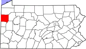 | |
| Boroughs | ||
| Townships |
| |
| CDPs | ||
| Unincorporated communities | ||
| ||
| Authority control |
|---|