Mercer County, Pennsylvania
Mercer County is a county located in the U.S. state of Pennsylvania. As of the 2010 census, the population was 116,638.[1] Its county seat is Mercer,[2] and its largest city is Hermitage. The county was created in 1800 and later organized in 1803.[3]
Mercer County | |
|---|---|
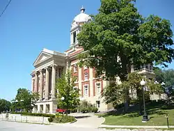 Mercer County Courthouse (1909) | |
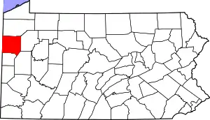 Location within the U.S. state of Pennsylvania | |
 Pennsylvania's location within the U.S. | |
| Coordinates: 41°19′N 80°15′W | |
| Country | |
| State | |
| Founded | November 7, 1803 |
| Named for | Hugh Mercer |
| Seat | Mercer |
| Largest city | Hermitage |
| Area | |
| • Total | 683 sq mi (1,770 km2) |
| • Land | 673 sq mi (1,740 km2) |
| • Water | 10 sq mi (30 km2) 1.5%% |
| Population | |
| • Estimate (2019) | 109,424 |
| • Density | 170/sq mi (70/km2) |
| Time zone | UTC−5 (Eastern) |
| • Summer (DST) | UTC−4 (EDT) |
| Congressional district | 16th |
| Website | www |
Mercer County is included in the Youngstown-Warren-Boardman, OH-PA Metropolitan Statistical Area.
Geography
According to the U.S. Census Bureau, the county has a total area of 683 square miles (1,770 km2), of which 673 square miles (1,740 km2) is land and 10 square miles (26 km2) (1.5%) is water.[4] It has a humid continental climate (Dfa/Dfb) and average monthly temperatures in Sharon range from 27.1 °F in January to 72.2 °F in July, while in Mercer borough they range from 25.4 °F in January to 70.1 °F in July.
Adjacent counties
- Crawford County (north)
- Venango County (east)
- Butler County (southeast)
- Lawrence County (south)
- Mahoning County, Ohio (southwest)
- Trumbull County, Ohio (west)
Demographics
| Historical population | |||
|---|---|---|---|
| Census | Pop. | %± | |
| 1800 | 3,228 | — | |
| 1810 | 8,277 | 156.4% | |
| 1820 | 11,681 | 41.1% | |
| 1830 | 19,729 | 68.9% | |
| 1840 | 32,873 | 66.6% | |
| 1850 | 33,172 | 0.9% | |
| 1860 | 36,856 | 11.1% | |
| 1870 | 49,977 | 35.6% | |
| 1880 | 56,161 | 12.4% | |
| 1890 | 55,744 | −0.7% | |
| 1900 | 57,387 | 2.9% | |
| 1910 | 77,699 | 35.4% | |
| 1920 | 93,788 | 20.7% | |
| 1930 | 99,246 | 5.8% | |
| 1940 | 101,039 | 1.8% | |
| 1950 | 111,954 | 10.8% | |
| 1960 | 127,519 | 13.9% | |
| 1970 | 127,175 | −0.3% | |
| 1980 | 128,299 | 0.9% | |
| 1990 | 121,003 | −5.7% | |
| 2000 | 120,307 | −0.6% | |
| 2010 | 116,638 | −3.0% | |
| 2019 (est.) | 109,424 | [5] | −6.2% |
| U.S. Decennial Census[6] 1790-1960[7] 1900-1990[8] 1990-2000[9] 2010-2019[1] | |||
As of the census[10] of 2000, there were 120,293 people, 46,712 households, and 32,371 families residing in the county. The population density was 179 people per square mile (69/km2). There were 49,859 housing units at an average density of 74 per square mile (29/km2). The racial makeup of the county was 93.13% White, 5.25% Black or African American, 0.11% Native American, 0.40% Asian, 0.02% Pacific Islander, 0.17% from other races, and 0.91% from two or more races. 0.67% of the population were Hispanic or Latino of any race. 37.7% were of German, 20.0% Irish, 14.9% Italian, 12.0% English, 6.4% American, 6.2% Polish, 3.7% Scotch-Irish, 3.3% Dutch ancestry.
There were 46,712 households, out of which 29.30% had children under the age of 18 living with them, 54.80% were married couples living together, 10.90% had a female householder with no husband present, and 30.70% were non-families. 27.00% of all households were made up of individuals, and 13.20% had someone living alone who was 65 years of age or older. The average household size was 2.44 and the average family size was 2.96.
In the county, the population was spread out, with 23.40% under the age of 18, 8.90% from 18 to 24, 26.10% from 25 to 44, 23.50% from 45 to 64, and 18.10% who were 65 years of age or older. The median age was 40 years. For every 100 females there were 94.70 males. For every 100 females age 18 and over, there were 90.80 males.
Government and politics
| Year | Republican | Democratic | Third parties |
|---|---|---|---|
| 2020 | 62.2% 36,143 | 36.3% 21,067 | 1.5% 907 |
| 2016 | 59.7% 31,544 | 35.5% 18,733 | 4.9% 2,562 |
| 2012 | 50.8% 25,925 | 47.5% 24,232 | 1.7% 882 |
| 2008 | 49.0% 26,565 | 48.8% 26,411 | 2.2% 1,192 |
| 2004 | 51.0% 26,311 | 48.2% 24,831 | 0.8% 422 |
| 2000 | 47.5% 23,132 | 48.9% 23,817 | 3.7% 1,783 |
| 1996 | 37.6% 17,213 | 50.3% 23,003 | 12.2% 5,563 |
| 1992 | 32.3% 16,081 | 46.7% 23,264 | 21.1% 10,491 |
| 1988 | 46.4% 21,301 | 52.9% 24,278 | 0.7% 301 |
| 1984 | 49.1% 24,211 | 50.0% 24,658 | 0.9% 434 |
| 1980 | 48.5% 22,372 | 42.8% 19,716 | 8.7% 4,002 |
| 1976 | 46.6% 22,469 | 51.9% 25,041 | 1.5% 725 |
| 1972 | 59.4% 27,961 | 38.4% 18,087 | 2.2% 1,052 |
| 1968 | 47.1% 23,131 | 46.5% 22,814 | 6.4% 3,160 |
| 1964 | 35.9% 18,153 | 63.7% 32,199 | 0.4% 211 |
| 1960 | 54.4% 29,109 | 45.3% 24,243 | 0.2% 128 |
| 1956 | 59.1% 28,785 | 40.6% 19,769 | 0.3% 120 |
| 1952 | 55.6% 26,424 | 43.7% 20,770 | 0.7% 343 |
| 1948 | 52.7% 18,916 | 44.9% 16,108 | 2.4% 862 |
| 1944 | 53.9% 19,606 | 45.6% 16,589 | 0.6% 212 |
| 1940 | 55.1% 21,058 | 44.4% 16,968 | 0.5% 189 |
| 1936 | 45.9% 18,493 | 51.8% 20,879 | 2.3% 939 |
| 1932 | 53.5% 14,057 | 41.7% 10,961 | 4.7% 1,240 |
| 1928 | 72.7% 22,599 | 26.4% 8,204 | 0.9% 280 |
| 1924 | 65.3% 14,639 | 16.5% 3,688 | 18.3% 4,093 |
| 1920 | 60.3% 11,575 | 25.1% 4,823 | 14.6% 2,801 |
| 1916 | 42.7% 5,866 | 46.5% 6,390 | 10.9% 1,495 |
| 1912 | 14.7% 1,873 | 31.8% 4,039 | 53.5% 6,806 |
| 1908 | 47.3% 6,497 | 39.8% 5,473 | 12.9% 1,774 |
| 1904 | 60.7% 8,574 | 27.2% 3,845 | 12.1% 1,714 |
| 1900 | 55.9% 6,950 | 39.6% 4,916 | 4.5% 559 |
| 1896 | 55.5% 7,262 | 42.1% 5,500 | 2.4% 315 |
| 1892 | 50.8% 5,874 | 42.7% 4,931 | 6.6% 757 |
| 1888 | 53.9% 6,428 | 40.3% 4,806 | 5.8% 689 |
| 1884 | 51.8% 6,357 | 39.6% 4,861 | 8.6% 1,052 |
| 1880 | 51.3% 6,079 | 42.5% 5,029 | 6.2% 735 |
Voter Registration
As of November 7, 2017, there were 70,587 registered voters in the county. Republicans hold a razor thin plurality of 395 (0.56%) voters. There were 30,929 registered Republicans, 30,534 registered Democrats, 8,697 voters registered to other parties, 353 to the Libertarian Party and 74 voters registered to the Green Party.[13]
Chart of Voter Registration
| Voter registration and party enrollment | |||||
|---|---|---|---|---|---|
| Party | Number of voters | Percentage | |||
| Republican | 30,929 | 43.82 | |||
| Democratic | 30,534 | 43.26 | |||
| Others | 8,697 | 12.32 | |||
| Libertarian | 353 | 0.50 | |||
| Green | 74 | 0.10 | |||
| Total | 70,587 | 100% | |||
Political bellwether
Mercer County was previously considered a political bellwether for the state of Pennsylvania since its demographics, urban/rural ratio, and party affiliation once closely mirrored the state as a whole. In 2000, Al Gore carried it against George W. Bush. This trend failed to hold true during 2004 Presidential election and 2008 Presidential election, in which Mercer County voted more conservatively than the rest of the state. In 2004, George W. Bush won Mercer County with 51% of the vote. That year John Kerry won the state as a whole with 51% of the popular vote. In 2008, John McCain won Mercer County by fewer than 200 votes, as he and Barack Obama each received roughly 49% of the popular vote. Barack Obama won the state of Pennsylvania as a whole with 55% of the popular vote. Each of the three statewide office winners also carried Mercer in 2008. In 2016, Donald Trump won Mercer County by 12,403 votes. Trump also won the state of Pennsylvania. Each of the three Republican candidates for statewide office carried Mercer County in 2016.
| Commissioner | Party | Title |
|---|---|---|
| Matthew McConnell | Republican | Chairman |
| Scott Boyd | Republican | Vice Chairman |
| Timothy McGonigle | Democrat | |
County officials
| Office | Official | Party |
|---|---|---|
| President Judge of Court of Common Pleas | Robert G. Yeatts | Democrat |
| Judge of Court of Common Pleas | Daniel P. Wallace | Republican |
| Judge of Court of Common Pleas | Vacant | |
| Judge of Court of Common Pleas | Vacant | |
| Clerk of Courts/Register of Wills | Kathleen M. Kloos | Democrat |
| District Attorney | Pete Acker | Republican |
| Coroner | John A. Libonati | Republican |
| Sheriff | Roni Shilling | Republican |
| Treasurer | Amber White | Republican |
| Prothonotary | Ruth Bice | Democrat |
| Recorder of Deeds | Dee Dee Zickar | Republican |
State Senate
| District | Senator | Party |
|---|---|---|
| 50 | Michele Brooks | Republican |
State House of Representatives
| District | Representative | Party |
|---|---|---|
| 7 | Mark Longietti | Democrat |
| 8 | Tedd Nesbit | Republican |
| 17 | Parke Wentling | Republican |
United States House of Representatives
| District | Representative | Party |
|---|---|---|
| 16 | Mike Kelly | Republican |
United States Senate
| Senator | Party |
|---|---|
| Pat Toomey | Republican |
| Bob Casey | Democrat |
Education
Higher education
- Butler County Community College (Pennsylvania) (Hermitage)
- Grove City College (Grove City)
- Thiel College (Greenville)
- Pennsylvania State University, Shenango Campus (Sharon)
Career-based education
- Laurel Technical Institute, Sharon
- Mercer County Career and Technical Center, Mercer
- Penn State Cosmetology Academy, Hermitage
- Sharon Regional Health System Schools of Nursing and Radiology, Sharon
Public school districts
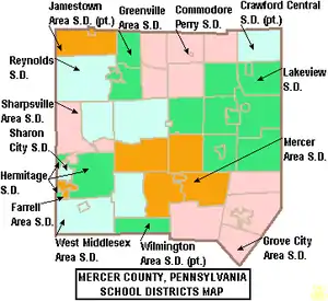
- Crawford Central School District
- Commodore Perry School District
- Farrell Area School District
- Greenville Area School District
- Grove City Area School District
- Hermitage School District
- Jamestown Area School District
- Lakeview School District
- Mercer Area School District
- Reynolds School District
- Sharon City School District
- Sharpsville Area School District
- West Middlesex Area School District
- Wilmington Area School District
Charter schools
Private schools
- Kennedy Catholic High School, Hermitage, PA.
Recreation
There is one Pennsylvania state park in Mercer County. Maurice K. Goddard State Park, named for Maurice K. Goddard, former Secretary of the Pennsylvania Department of Environmental Resources, is just off exit 130 of Interstate 79 on Pennsylvania Route 358 near Stoneboro.
The Wendell August Forge, the last remaining working forge in the state, was open to the public for tours, but it burned down on March 6, 2010.[16] It has since reopened in new facilities.
Mercer County Court House built in 1909.
Communities
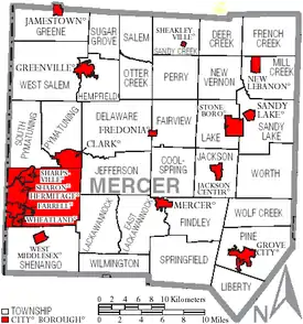
Under Pennsylvania law, there are four types of incorporated municipalities: cities, boroughs, townships, and, in one case, towns. The following cities, boroughs and townships are located in Mercer County:
Boroughs
Townships
- Coolspring
- Deer Creek
- Delaware
- East Lackawannock
- Fairview
- Findley
- French Creek
- Greene
- Hempfield
- Jackson
- Jefferson
- Lackawannock
- Lake
- Liberty
- Mill Creek
- New Vernon
- Otter Creek
- Perry
- Pine
- Pymatuning
- Salem
- Sandy Creek
- Sandy Lake
- Shenango
- South Pymatuning
- Springfield
- Sugar Grove
- West Salem
- Wilmington
- Wolf Creek
- Worth
Census-designated places
Unincorporated communities
- Blacktown
- Carlton
- Clarks Mills
- Fairview (village)
- Hadley
- Kennard
- Kremis
- Milledgeville
- New Vernon (village)
- Osgood
- Petersburg
- Transfer
- Williams Corners
Former community
- Hickory Township-became the Municipality of Hermitage in 1976, and then the City of Hermitage in 1984.[17]
Population ranking
The population ranking of the following table is based on the 2010 census of Mercer County.[18]
† county seat
| Rank | City/Town/etc. | Municipal type | Population (2010 Census) |
|---|---|---|---|
| 1 | Hermitage | City | 16,220 |
| 2 | Sharon | City | 14,038 |
| 3 | Grove City | Borough | 8,322 |
| 4 | Greenville | Borough | 5,919 |
| 5 | Farrell | City | 5,111 |
| 6 | Sharpsville | Borough | 4,415 |
| 7 | Reynolds Heights | CDP | 2,061 |
| 8 | † Mercer | Borough | 2,002 |
| 9 | Stoneboro | Borough | 1,051 |
| 10 | Lake Latonka | CDP | 1,012 |
| 11 | West Middlesex | Borough | 863 |
| 12 | Sandy Lake | Borough | 659 |
| 13 | Clark | Borough | 640 |
| 14 | Wheatland | Borough | 632 |
| 15 | Jamestown | Borough | 617 |
| 16 | Fredonia | Borough | 502 |
| 17 | Jackson Center | Borough | 224 |
| 18 | New Lebanon | Borough | 188 |
| 19 | Sheakleyville | Borough | 142 |
References
- "State & County QuickFacts". United States Census Bureau. Archived from the original on June 6, 2011. Retrieved November 20, 2013.
- "Find a County". National Association of Counties. Archived from the original on May 31, 2011. Retrieved June 7, 2011.
- "Pennsylvania: Individual County Chronologies". Pennsylvania Atlas of Historical County Boundaries. The Newberry Library. 2008. Retrieved March 13, 2015.
- "2010 Census Gazetteer Files". United States Census Bureau. August 22, 2012. Retrieved March 9, 2015.
- "Population and Housing Unit Estimates". Retrieved May 21, 2020.
- "U.S. Decennial Census". United States Census Bureau. Retrieved March 9, 2015.
- "Historical Census Browser". University of Virginia Library. Retrieved March 9, 2015.
- Forstall, Richard L., ed. (March 24, 1995). "Population of Counties by Decennial Census: 1900 to 1990". United States Census Bureau. Retrieved March 9, 2015.
- "Census 2000 PHC-T-4. Ranking Tables for Counties: 1990 and 2000" (PDF). United States Census Bureau. April 2, 2001. Retrieved March 9, 2015.
- "U.S. Census website". United States Census Bureau. Retrieved January 31, 2008.
- Leip, David. "Dave Leip's Atlas of U.S. Presidential Elections". uselectionatlas.org. Retrieved March 23, 2018.
- "Our Campaigns - U.S. President". Retrieved January 22, 2021.
- "Election statistics" (PDF). dos.pa.gov. November 7, 2017.
- Pennsylvania Department of Education (2011). "Charter Schools".
- "Landmark metal forge burns in Mercer County." Pittsburgh Post-Gazette. Online. March 06, 2010.
- "RootsWeb.com Home Page". www.rootsweb.ancestry.com.
- Promotions, Center for New Media and. "US Census Bureau 2010 Census". www.census.gov. Retrieved March 23, 2018.
External links
- Government - https://web.archive.org/web/20071006122227/http://www.mcc.co.mercer.pa.us/
- https://web.archive.org/web/20071007130714/http://www.mercercountypa.org/
Municipalities and communities of Mercer County, Pennsylvania, United States | ||
|---|---|---|
| Cities | | |
| Boroughs | ||
| Townships |
| |
| CDPs | ||
| Unincorporated communities | ||
| ||

| Authority control |
|---|