Shelley, Idaho
Shelley is a city in Bingham County, Idaho. The population was 4,409 at the 2010 census. The mascot for the city's high school is a russet-burbank potato that wears a crown, robe and scepter.
Shelley, Idaho | |
|---|---|
 | |
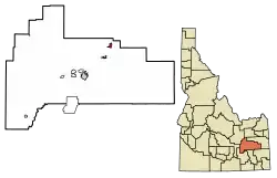 Location of Shelley in Bingham County, Idaho. | |
| Coordinates: 43°22′46″N 112°7′26″W | |
| Country | United States |
| State | Idaho |
| County | Bingham |
| Area | |
| • Total | 1.81 sq mi (4.68 km2) |
| • Land | 1.81 sq mi (4.68 km2) |
| • Water | 0.00 sq mi (0.00 km2) |
| Elevation | 4,633 ft (1,412 m) |
| Population | |
| • Total | 4,409 |
| • Estimate (2019)[3] | 4,466 |
| • Density | 2,472.87/sq mi (954.83/km2) |
| Time zone | UTC-7 (Mountain (MST)) |
| • Summer (DST) | UTC-6 (MDT) |
| ZIP code | 83274 |
| Area code(s) | 208, 986 |
| FIPS code | 16-73450 |
| GNIS feature ID | 0397154 |
| Website | ci |
Since 1927 Shelley has been home to the "Idaho Annual Spud Day", which is celebrated on the 3rd Saturday of September. It typically features a parade, live bands, a Spud Tug, a spud-picking Contest, and free baked potatoes.[4]
History
Shelley was established in 1904. It was named for John F. Shelley, who moved to the area in 1892. He'd moved to the area intending to open a small store, and needed lumber and other supplies to build it. Since the site was some distance from the nearest existing community, he asked the railroad company to make a special stop to offload the supplies he'd ordered. They consented, provided he could offload the supplies in under 20 minutes. His daughter, Lottie, wrote the following in her personal history:
With the help of Chris Mickelson and others, the lumber was thrown off the train on both sides of the track. Later a spur was put in here by the railroad company.
Now they needed a name for the town. Mother suggested 'Shelco'; Father said, 'Shelton,' so they drew cuts and Mother won." Shelco was submitted to the railroad company and they replied: 'Call your town what you wish, but we have already named the spur, Shelley '.
That is how the town got its name.
— Charlotte Shelley, [5]
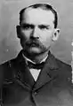 John F. Shelley
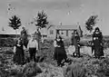 John F. Shelley and his wife stand in the background. In the foreground are the rest of his family: Mary, Tom, Charlotte (Lottie), Docia, Hannah Davis
On September 4, 1902 a large fire destroyed seven buildings on State Street. Only two buildings, a general merchandise store and Nalder's furniture store, were saved. Soren Yorgesen, a local Justice of the Peace and proprietor of the first hotel in Shelley recounts the experience as follows:
...One windy afternoon in the heat of the summer, a fire started in a small grocery store operated by James Jensen. It did not take long until the wind was fanning a flame that wiped out quite a long string of frame buildings - two saloons, restaurant, Odd Fellows Hall, Post Office and Confectionery, Grocery Store, and dwelling.
— Soren Yorgesen, [5]
Geography
Shelley is located at 43°22′46″N 112°7′26″W (43.379490, -112.123846).[6]
According to the United States Census Bureau, the city has a total area of 1.81 square miles (4.69 km2), all of it land.[7]
Shelley is located on the eastern side of the Snake River, facing the Blackfoot Mountains.
Demographics
| Historical population | |||
|---|---|---|---|
| Census | Pop. | %± | |
| 1910 | 537 | — | |
| 1920 | 1,223 | 127.7% | |
| 1930 | 1,447 | 18.3% | |
| 1940 | 1,751 | 21.0% | |
| 1950 | 1,856 | 6.0% | |
| 1960 | 2,612 | 40.7% | |
| 1970 | 2,614 | 0.1% | |
| 1980 | 3,300 | 26.2% | |
| 1990 | 3,536 | 7.2% | |
| 2000 | 3,813 | 7.8% | |
| 2010 | 4,409 | 15.6% | |
| 2019 (est.) | 4,466 | [3] | 1.3% |
| U.S. Decennial Census[8] | |||
 Curt Brinkman Park features a skateboarding park that was created by James Simpson in 1994. Shelley High School is in the background.
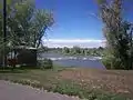 A gazebo on the greenbelt in Shelley, ID overlooks the Snake River as it flows over some rocks. This gazebo was destroyed in 2009.
 The annual Spud Day Potato Festival at the Shelley City Park attracts thousands as seen from a helicopter in September 2011.
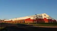 Shelley High School, nicknamed 'the Spud Cellar', houses the community's 600 high school students.
2010 census
As of the census[2] of 2010, there were 4,409 people, 1,445 households, and 1,123 families residing in the city. The population density was 2,435.9 inhabitants per square mile (940.5/km2). There were 1,531 housing units at an average density of 845.9 per square mile (326.6/km2). The racial makeup of the city was 89.0% White, 0.3% African American, 0.8% Native American, 0.7% Asian, 0.2% Pacific Islander, 7.0% from other races, and 2.1% from two or more races. Hispanic or Latino of any race were 14.0% of the population.
There were 1,445 households, of which 49.1% had children under the age of 18 living with them, 61.6% were married couples living together, 12.1% had a female householder with no husband present, 4.0% had a male householder with no wife present, and 22.3% were non-families. 19.6% of all households were made up of individuals, and 7.1% had someone living alone who was 65 years of age or older. The average household size was 3.05 and the average family size was 3.53.
The median age in the city was 27.8 years. 36.1% of residents were under the age of 18; 9.6% were between the ages of 18 and 24; 25.6% were from 25 to 44; 19.2% were from 45 to 64; and 9.5% were 65 years of age or older. The gender makeup of the city was 49.4% male and 50.6% female.
2000 census
As of the census[9] of 2000, there were 3,813 people, 1,201 households, and 989 families residing in the city. The population density was 2,884.5 people per square mile (1,115.3/km2). There were 1,253 housing units at an average density of 947.9 per square mile (366.5/km2). The racial makeup of the city was 89.93% White, 0.18% African American, 0.68% Native American, 0.26% Asian, 0.03% Pacific Islander, 6.74% from other races, and 2.18% from two or more races. Hispanic or Latino of any race were 11.78% of the population.
There were 1,201 households, out of which 48.9% had children under the age of 18 living with them, 67.0% were married couples living together, 13.0% had a female householder with no husband present, and 17.6% were non-families. 15.3% of all households were made up of individuals, and 7.2% had someone living alone who was 65 years of age or older. The average household size was 3.14 and the average family size was 3.50.
In the city, the population was spread out, with 35.6% under the age of 18, 11.5% from 18 to 24, 25.5% from 25 to 44, 16.8% from 45 to 64, and 10.6% who were 65 years of age or older. The median age was 27 years. For every 100 females, there were 96.2 males. For every 100 females age 18 and over, there were 90.3 males.
The median income for a household in the city was $39,318, and the median income for a family was $41,223. Males had a median income of $32,154 versus $20,121 for females. The per capita income for the city was $13,921. About 7.9% of families and 9.6% of the population were below the poverty line, including 10.6% of those under age 18 and 2.0% of those age 65 or over.
Notable people
- Lavina Fielding Anderson, LDS scholar and author
- Curt Brinkman, Paralympic athlete
- Lewis Croft, actor
- Brad Daw, member of the Utah House of Representatives
- Hadley Foster, men's college volleyball coach
- Ogden Kraut, religious author
- Darwin Young, former member of the Idaho House of Representatives
References
- "2019 U.S. Gazetteer Files". United States Census Bureau. Retrieved July 9, 2020.
- "U.S. Census website". United States Census Bureau. Retrieved 2012-12-18.
- "Population and Housing Unit Estimates". United States Census Bureau. May 24, 2020. Retrieved May 27, 2020.
- Past Events - Spud Day City of Shelley, May 8, 2014
- "Bingham County History, Written and Compiled by the People of Bingham County". Taylor Publishing Company. 1985. Library of Congress number 85072293
- "US Gazetteer files: 2010, 2000, and 1990". United States Census Bureau. 2011-02-12. Retrieved 2011-04-23.
- "US Gazetteer files 2010". United States Census Bureau. Archived from the original on 2012-01-25. Retrieved 2012-12-18.
- "Census of Population and Housing". Census.gov. Retrieved June 4, 2015.
- "U.S. Census website". United States Census Bureau. Retrieved 2008-01-31.
External links
Municipalities and communities of Bingham County, Idaho, United States | ||
|---|---|---|
| Cities | Map of Idaho highlighting Bingham County | |
| CDPs | ||
| Unincorporated communities | ||
| Indian reservation | ||
| Footnotes | ‡This populated place also has portions in an adjacent county or counties | |
| ||
| Authority control |
|---|