Shermanbury
Shermanbury is a village and civil parish in the Horsham District of West Sussex, England. It lies on the A281 road approximately 2 miles (3 km) north of Henfield. The present day village consists mainly of a ribbon development of bungalows on the east side of the A281, while the ancient parish church is to the east by Shermanbury Place. Between these is Ewhurst Manor, a 16th-century house[3] on an old moated site with a 14th-century stone gatehouse[4] and nearby artificial lake and farmstead.
| Shermanbury | |
|---|---|
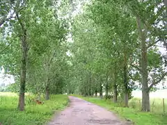 The avenue of trees leading to the church | |
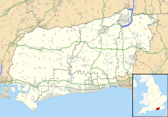 Shermanbury Location within West Sussex | |
| Area | 7.75 km2 (2.99 sq mi) [1] |
| Population | 454 [1] 2001 Census 542 (2011 Census including Wineham)[2] |
| • Density | 59/km2 (150/sq mi) |
| OS grid reference | TQ205192 |
| • London | 38 miles (61 km) N |
| Civil parish |
|
| District | |
| Shire county | |
| Region | |
| Country | England |
| Sovereign state | United Kingdom |
| Post town | HORSHAM |
| Postcode district | RH13 |
| Dialling code | 01403 |
| Police | Sussex |
| Fire | West Sussex |
| Ambulance | South East Coast |
| UK Parliament | |
The eastern River Adur flows through Shermanbury, where it is met by the Cowfold Stream. The Normal Tidal Limit is at the footbridge near the church although a weir further downstream means only the highest tides reach this far. Boats could reach Mock Bridge (where the A281 crosses the river) until the early 1800s.
The parish has a land area of 775 hectares (1,915 acres). In the 2001 census 454 people lived in 182 households of whom 253 were economically active. The population at the 2011 Census was 542.[2]
History
In the Domesday Book, based on a survey completed in 1086, the manor of Shermanbury, then called Salmonesberie, is held by Ralph from William de Braose, having been formerly held by Azor from King Harold. There are two ploughs, one belonging to the lord and one shared by one villager and three smallholders. There is a small church and four slaves. There are three other manors in Shermanbury parish, Woolfly, also held by Ralph, and Morley and Sakeham held by William son of Ranulph.[5] The parishes of Shermanbury and Cowfold comprised the Saxon hundred of Hamfelt, and was on the eastern boundary of the Norman Rape of Bramber.[6]
The parish church
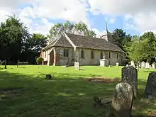
The Anglican church of St. Giles is well away from the modern roads, approached along a tree-lined bridleway leading to Shermanbury Place, east of the Brighton road. A small church is mentioned in the Domesday Book, but the present structure is of 14th-century origin. The roof is of Horsham stone slates with a weatherboarded belltower at the west end, containing two bells. The door and stone roofed porch are at the west end. Inside 18th century pews have the names of houses to which they were allocated painted on the backs.[7][8][9]
Shermanbury Place

Shermanbury Place, adjacent to the church in Shermanbury Park, is a mansion built by John Challen in 1779 on the site of a 16th-century Tudor house with projecting crosswings. The Tudor house was built by one of the Comber family. Sir Richard Comber was Clarenceaux King of Arms. His son Doctor Thomas Comber was prominent in the Church of England. Educated at Trinity College, Cambridge he rose to become master of the college, and later vice-chancellor of the university. As the king's chaplain he was staunchly royalist and was imprisoned by parliament for attempting to give the university treasures to the king.[6]
Ewhurst Manor
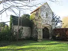
The moated manor house was built by Thomas Peverel during the reign of Edward I. Only the early 14th-century gatehouse, with a porters lodge attached survives. A room over the gateway has a cross shaped loop window. Ewhurst manor occupied the western third of Shermanbury parish. The existence of a deer park at Ewhurst was recorded in 1274, during the 14th century, and in 1538.[9]
References
| Wikimedia Commons has media related to Shermanbury. |
- "2001 Census: West Sussex – Population by Parish" (PDF). West Sussex County Council. Archived from the original (PDF) on 8 June 2011. Retrieved 12 April 2009.
- "Civil Parish population 2011". Neighbourhood Statistics. Office for National Statistics. Retrieved 2 October 2016.
- "Ewhurst Manor". Historic England. English Heritage. 2020. Retrieved 16 November 2020.
- "The gateway and porters lodge to the north west of Ewhurst Manor". Historic England. English Heritage. 2020. Retrieved 16 November 2020.
- "Doomsday Entry for Shermanbury parish - 4 manors". Adur.org.uk. Retrieved 13 December 2014.
- "From History Of Sussex 2 by Horsefield 1835". Adur.org.uk. Retrieved 13 December 2014.
- "Churches in Sussex : Shermanbury". Sussexchurches.co.uk. Retrieved 13 December 2014.
- "St Giles Church, Shermanbury, West Sussex - An ancient Saxon church above the River Adur". Sussexchurches.co.uk. Archived from the original on 23 December 2014. Retrieved 13 December 2014.
- "Shermanbury: Church". British-history.ac.uk. Retrieved 13 December 2014.