Shigar
Shigar (Urdu: شگر) is the headquarter of its namesake district and tehsil in the Baltistan division of Gilgit–Baltistan in northern Pakistan. It is located at the bank of Shigar River in the most remote and dramatic part of the region. It is a popular site for tourists and trekkers and contains many historical buildings of architectural significance associated with several different communities.
Shigar
شگر | |
|---|---|
 Shigar, Gilgit Baltistan, Pakistan | |
 Shigar Location in the Karakoram region | |
| Coordinates: 35°25′25″N 75°44′20″E | |
| Province | Gilgit–Baltistan |
| District | Shigar |
| Elevation | 2,230 m (7,320 ft) |
| Time zone | UTC+5:00 (PST) |
The town is inhabited almost exclusively by the Balti people of Tibetan descent. Almost 65% of the population belongs to the Shia sect of Islam, 26% belongs to the Norbakhshi sect and the remaining belong to the Sunni sect. It is the gateway to the great mountain range of Karakoram including where 5 Eight-thousanders of the world falls, including the K2.[1]
The town serves as a gateway to the Karakoram mountains including K2, via the Shigar Valley.[2]
Tourist Attractions
Popular tourist attractions in the town include:
- Shigar Fort
- Amburik Mosque
- Khilingrong Mosque
- Khanqah-e-Muallah Shigar
- Hashoo pi Bhag
- Marapi Ranga
- Ree Masjid
- Astana of Syed Mir Yahya
- Khureed Ranga Gulabpur
- Choutran (Garam Chasma)
- Ticho Ranga Gulabpur
- Khanqah Gulabpur
- Wazirpur Khanqah
- Bissel (Garam Chasma)
- Hassan Abad (Bunpa)
- Kharmang Pi Dus
Climate
Shigar has a cold desert climate (Köppen: BWk).[3]
| Month | Jan | Feb | Mar | Apr | May | Jun | Jul | Aug | Sep | Oct | Nov | Dec | Year |
|---|---|---|---|---|---|---|---|---|---|---|---|---|---|
| Average high °C (°F) | −0.4 (31.3) |
2.2 (36.0) |
8.9 (48.0) |
16.2 (61.2) |
21.8 (71.2) |
26.8 (80.2) |
30.3 (86.5) |
30.0 (86.0) |
25.0 (77.0) |
18.4 (65.1) |
10.9 (51.6) |
3.5 (38.3) |
16.1 (61.0) |
| Daily mean °C (°F) | −5.2 (22.6) |
−3.0 (26.6) |
3.9 (39.0) |
10.6 (51.1) |
15.4 (59.7) |
19.9 (67.8) |
23.4 (74.1) |
23.0 (73.4) |
18.1 (64.6) |
11.4 (52.5) |
4.3 (39.7) |
−1.6 (29.1) |
10.0 (50.0) |
| Average low °C (°F) | −9.9 (14.2) |
−8.1 (17.4) |
−1.0 (30.2) |
5.0 (41.0) |
9.1 (48.4) |
13.0 (55.4) |
16.5 (61.7) |
16.1 (61.0) |
11.3 (52.3) |
4.4 (39.9) |
−2.2 (28.0) |
−6.6 (20.1) |
4.0 (39.1) |
| Average precipitation mm (inches) | 18 (0.7) |
17 (0.7) |
29 (1.1) |
22 (0.9) |
23 (0.9) |
6 (0.2) |
7 (0.3) |
8 (0.3) |
9 (0.4) |
5 (0.2) |
3 (0.1) |
12 (0.5) |
159 (6.3) |
| Source: Climate-Data.org[3] | |||||||||||||
Gallery
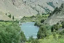
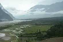
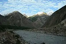
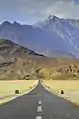 All roads out of Shigar, such as the one to Skardu pictured here, pass through rugged mountainous terrain.
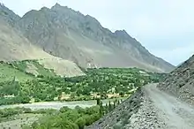
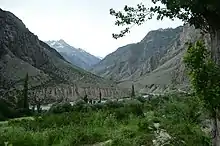
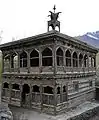 The 14th century Amburiq Mosque dates from the time the region converted en masse to Islam from Buddhism.
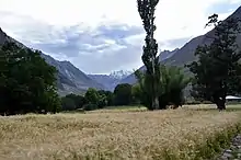
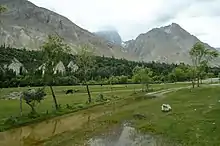
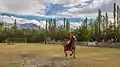 Polo is enjoyed by local Pakistanis in Shigar.
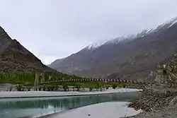
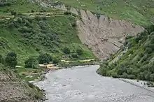
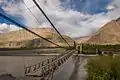 Gulabpur Bridge
See also
References
- "Archived copy". Archived from the original on 10 January 2015. Retrieved 9 January 2015.CS1 maint: archived copy as title (link)
- Valley, Shigar. "Places To Visit in Shigar Valley". Skardu.pk. Skardu.pk. Retrieved 12 July 2018.
- "Shigar climate: Average Temperature, weather by month, Shigar weather averages - Climate-Data.org". en.climate-data.org. Retrieved 30 May 2020.
| Wikimedia Commons has media related to Shigar. |
