Shingwedzi
Shingwedzi (also Xingwedzi in modern Tsonga orthography[1]) is a rest camp (i.e. tourist camp) and ranger's post situated in the northern section of the Kruger National Park. They are located on the southern bank of the Shingwedzi River, for which they were named,[1] in Limpopo province, South Africa. The surrounding country formerly constituted the Singwitsi Reserve, proclaimed in 1903, which encompassed over 5,000 square kilometers.[2] The region was over-hunted by the end of the 19th century, its big game depleted and its elephant population completely decimated.[3] The name "Shingwedzi" is of Tsonga origin, and was perhaps derived from "Shing-xa-goli", perhaps a local chieftain, and "njwetse", the sound of iron rubbing against iron.[4]
.jpg.webp)
.jpg.webp)
History
During the 19th century the area had only a small native population,[5] as the presence of predators and tsetse fly prevented cattle husbandry. To the immediate east Soshangane established himself as overlord of the lower Bileni/Limpopo valley from 1827/28 to 1835,[6] displacing resident Tsonga people in clashes like the Battle of Xihaheni, while moving northwards.
The rinderpest epidemic of 1896 however ravaged the region's buffalo population, and with it the tsetse fly, the vector of nagana or sleeping sickness.[7] Some now looked at the region for its economic prospects. By the end of the 19th century this remote northeastern part of South Africa was the abode of poachers, illegal loggers, illegal prospecters and illegal recruiters of black labour from across the border.[8]
In December 1902, Leonard Ledeboer, a Zoutpansberg resident who had switched sides during the war, suggested the establishment of a reserve to sir Godfrey Lagden of the Department of Native Affairs.[7] The Administrative Proclamation No. 19 of May 1903 which established the Singwitsi Reserve, also brought an end to the lawless exploitation of the region. The reserve boundary went from the Groot and Klein Letaba confluence in a straight line north to Shikumdu Hill, turning northeastwards to the Levuvhu and Crook's Corner. From the Limpopo it ran south along the Portuguese border to the Olifants, and west along the Letaba to the aforementioned confluence.[9] The remote and beautiful reserve could boast with hills topped by baobab trees, dramatic gorges, including Lanner Gorge, lush riparian vegetation, plains with impressive mopane trees, and flood plains adorned with ilala palms and fever trees.[5]
First rangers
Major James Stevenson-Hamilton was warden of the Sabi (since 1902) as well as Singwitsi Reserves. During his inspection tour of Singwitsi during September and October 1903, Stevenson-Hamilton found that game was scarce. He was nevertheless delighted with the region and found it 'well worth protecting'.[7] Besides the relics of hunting camps[2] there were numerous small African homesteads, the occupants of which subsisted on trapping and hunting by bow and arrow.[3] The scarcity of game he however attributed to systematic hunting by Boer hunters, who were in his opinion doing more damage in a week than the Africans in a year. They had apparently exterminated all the elephant, rhino and eland during the war, and regarded game laws and ordinances as "waste paper", while having "no sporting instincts and no sense of honour as a rule".[3]
From 1904 to 1919 major A. A. Fraser was his only ranger in Singwitsi.[8] The eccentric, red-bearded Fraser was recruited from Scotland as ranger for the small Pongola Reserve (dissolved in 1921),[7] before he was transferred to Malunzane (also Malundzane) in Singwitsi. This deserted base of a former labour recruiter became Fraser's ranger post. It consisted of five rondavels on the bank of the Shongololo stream, not far from the present Mopani rest camp. Fraser was a poor administrator however, considering office work 'undignified', and was besides a poor manager of his native staff. He also developed poor relations with government officials of the district.[7] An additional ranger, J. J. Coetsee, arrived in 1919 from East Africa.[1] He established his ranger's post at the foot of Dimbo Kop in the far north. This he named Punda Maria, perhaps a playful corruption of phande mariha (or "border of the winter"), the alleged Venda appellation for this region.[10] When Stevenson-Hamilton returned from Sudan to South Africa in 1920, he observed that a depressing retrogression had occurred in terms of discipline, management and faunal preservation in both the Sabi and Singwitsi Reserves.[7]
Merged with Sabi Reserve
In expectation of a government buyout of the land in these reserves, the Singwitsi and Sabi became the Transvaal Game Reserve in 1923, then still privately owned to a large extent. Deneys Reitz, Minister of Lands from 1921 to 1924, and his successor Piet Grobler, advocated the fulfillment of 'Paul Kruger's dream', and the Kruger National Park was established in 1926.[7] The persons involved in the Kruger Park's creation, the extent of their contributions and their political motives are matters of debate, but may be seen as the culmination of various protectionist movements and many strands of thought.[7] By 1932 a good dirt road linked Letaba, Shingwedzi and Punda Maria for the first time, but this road was only accessible to tourists during the winter months.[7]
Camp facilities
Shingwedzi's 31 tourist huts were completed in 1933, but these were only enclosed by a fence much later.[11] Construction of Punda Maria's tourist huts was likewise undertaken during the same year. Current accommodation of Shingwedzi camp consists of 66 bungalows, 12 huts, 1 family cottage and 1 guest house, besides 50 camping sites. A new administrative complex was added in 1982/3, then outside the camp, and the A-circle huts were upgraded to bungalows. A landing strip is situated just south of the camp.
The Kanniedood dam was constructed 9km downstream of the camp in 1978, but was demolished 40 years later, in 2018, in line with a rehabilitation project which aims to limit artificial water points for animals.[12] The artificial supply of water in a naturally dry region caused erosion and environmental degradation. Rare herbivore species such as roan suffered due to increased grazing competition by abundant grazers,[12] and from predation by lions which likewise expanded their territories.
Hiking trail
The Mphongolo Backpack Trail starts from Shingwedzi Camp, but doesn't follow a specific route. It enables small groups of visitors to explore areas like the Mphongolo River, Bububu River, Phonda Hills, sodic pans or stone-walled ruins.[13]
Rains and floods
The Shingwedzi River flows only during the summer months, and diminishes to shrinking pools in winter.[4] Heavy rains are normal at the start of each year, which may affect tourist roads, bridges, picnic spots and bush camps. On 24 February 2000 the Shingwedzi River reached record levels when cyclone Leon–Eline struck the northern lowveld. These levels were surpassed on 20 January 2013 when Shingwedzi and Sirheni camps were completely submerged by flood water[14] after 400 mm of rain in a week caused the Mphongolo and Shingwidzi Rivers to burst their banks.[15] 262 people were evacuated on the 20th and airlifted to safety the next day. Some staff were trapped as roads became submerged and survived by taking shelter in trees or on roofs. Some staff and tourists lost all their belongings, and the cost of rebuilding was over R150 million.[15] The camp was reopened for tourists in June 2013.[16]
Fauna and flora
The camp is situated in elephant country, and breeding herds of 50 to 60 animals frequent the vicinity. The tusks of a local elephant bull named "Shingwedzi" are now displayed in the museum at Letaba. "Shingwedzi" died in 1981 near the camp, and was one of the so-called "magnificent seven" that roamed the park during the 1970s and 80s.[4] Other Afrotheria which are sparsely resident include the aardvark, Petrodromus, two Elephantulus species and the golden mole. Two species of hyrax are allopatrically distributed, namely the yellow-spotted hyrax which occurs commonly along the northern bush-clad hills and sandstone outcrops, and the rock hyrax, which occurs patchily southwards of the Bubube and Shingwedzi Rivers, but no further south than the Olifants.[17] Ranger D. Swart reported seeing a group of 6 bat-eared foxes near Shingwedzi in 1967, a species previously thought to be restricted to the western parts of southern Africa. Further sightings in 1967 and 1969 confirmed their presence.[18]
Anthrax, caused by the bacterium Bacillus anthracis, is endemic to the area, and causes sporadic outbreaks.[19] It affects mainly ungulates, but also carnivores and humans. As anthrax inhibits blood clotting, the blood of deceased animals seep into the soil. The spores survive for decades in substrates with elevated calcium content or neutral-to-alkaline pH levels.[19]
The immediate vicinity of Shingwedzi camp contains some riparian vegetation with large trees, and narrow alluvial plains created by centuries of flooding, flank the river on each side. Here Transvaal mustard trees, weeping boer-bean, sausage tree, Natal mahogany and brack thorn may be found, but further afield the land is dominated by mopane shrub, punctuated by apple-leaf trees.[20]
Land claim
In 1905 chief Sundhuza Mhinga and his Mhinga clan were dispossessed of their land in this area, and moved to land west of the park. In 1999 chief Shilungwa Mhinga claimed all land in the park north of the Shingwedzi River, and intended to use the southern portion for ecotourism hotels and other parts for lodges. Land restitution legislation however assists only those dispossessed since 1913, so as to avoid conflicting claims.[21]
Gallery
.jpg.webp) Yellow-billed stork and crocodiles patrolling the flooded causeway
Yellow-billed stork and crocodiles patrolling the flooded causeway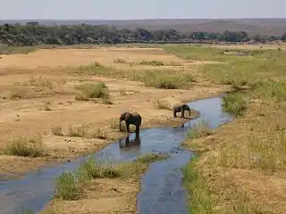 Elephants on the sandy river bed
.jpg.webp) Preserved tusks of "Shingwedzi" (c.1934-1981) at the museum in Letaba camp
Preserved tusks of "Shingwedzi" (c.1934-1981) at the museum in Letaba camp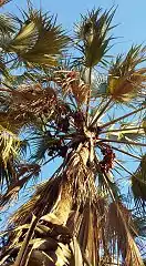 Real fan palm at the southern limit of its range
References
| Wikimedia Commons has media related to Shingwedzi. |
- Jenkins, Elwyn (2007). Falling Into Place: The Story of Modern South African Place Names. New Africa Books. pp. 97–100. ISBN 9780864866899.
- Bulpin, T. V. (1975). "The Kruger National Park". The Transvaal (A Collection of the Mobil Treasury of Travel Series covering the Transvaal). Cape Town: T. V. Bulpin. ISBN 0-949956-12-0.
- Dlamini, ? (12 May 2011). "Kruger Park's future lies with its neighbours". pressreader.com. Business Day. Retrieved 6 August 2018.CS1 maint: numeric names: authors list (link)
- "Shingwedzi Rest Camp - Kruger National Park, South Africa". Siyabona Africa. krugerpark.co.za. 2017. Retrieved 5 August 2018.
- Fleminger, David. "1903 The Shingwedzi Reserve in Kruger Park". southafrica.co.za. Retrieved 20 November 2018.
- Omer-Cooper (1966:57), Elkiss (1981:62)
- Carruthers, Jane (1995). The Kruger National Park: A Social and Political History (PDF). Pietermaritzburg: University of Natal Press. pp. 30–50.
- Stevens, Joep (11 December 2014). "Kruger History: A history of Punda Maria and vicinity". krugerhistory.com. Retrieved 6 August 2018.
- Stevens, Joep (5 December 2014). "Kruger History: General History". krugerhistory.com. Retrieved 6 August 2018.
- Jenkins, Elwyn (2007). Falling into place : the story of modern South African place names. New Africa Books. p. 101. ISBN 9780864866899.
- "Game Drive around Shingwedzi". Siyabona Africa: Kruger National Park. krugerpark.co.za. Retrieved 5 December 2019.
- Zietsman, Gabi (2018-04-04). "SANParks will demolish Kanniedood dam in Kruger for the environment". traveller24.com. Retrieved 14 March 2019.
- Desmet, Andrew; et al. "Mphongolo Backpack trail Explore Krugers northern wilderness areas". krugerpark.co.za. Retrieved 5 August 2018.
- "Kruger's Shingwedzi reopens after floods" (news24.com). City Press. 13 June 2013. Retrieved 5 August 2018.
- Barry, Hanna (December 2013). "Rebuilding Shingwedzi: how insurance saved SANParks" (PDF). emeraldsa.co.za. REDRiskSA. Retrieved 6 August 2018.
- "Shingwedzi re-opens camp following devastating flood". showme.co.za. The Write News Agency, Nelspruit News. 13 June 2013. Retrieved 5 August 2018.
- Pienaar, U. de V.; Rautenbach, I. L.; de Graaff, G. (1980). The Small Mammals of the Kruger National Park. Pretoria: National Parks Board of South Africa. pp. 11–15, 22–25, 105–110. ISBN 0-86953-018-6.
- Pienaar, U. de V. (1970). "A note on the occurrence of Bat-eared fox Otocyon megalotis (Desmarest) in the Kruger National Park". Koedoe. 13 (1): 1–22. doi:10.4102/koedoe.v13i1.727.
- Steenkamp, P. J. "Ecological suitability modelling for anthrax in the Kruger National Park, South Africa". repository.up.ac.za. University of Pretoria. Retrieved 20 February 2020.
- "Shingwedzi Rest Camp: Flora and Fauna". sanparks.org. Retrieved 13 February 2020.
- ka’Nkosi, Sechaba (29 Jan 1999). "Two clans claim part of the Kruger". Mail&Guardian. Retrieved 13 November 2018.