Ship canal
A ship canal is a canal especially intended to accommodate ships used on the oceans, seas, or lakes to which it is connected.[1]
Ship canals can be distinguished from barge canals, which intended to carry barges and other vessels specifically designed for river and/or canal navigation. Because of the constraints of accommodating vessels capable of navigating large bodies of open water, a ship canal typically offers deeper water and higher bridge clearances than a barge canal of similar vessel length and width constraints.[2]
Ship canals may be specially constructed from the start to accommodate ships, or less frequently they may be enlarged barge canals or canalized or channelized rivers. There are no specific minimum dimensions for ship canals, with the size being largely dictated by the size of ships in use nearby at the time of construction or enlargement.[3]
Ship canals may be constructed for a number of reasons, including:
- To create a shortcut and avoid lengthy detours.
- To create a navigable shipping link between two land-locked seas or lakes.
- To provide inland cities with a direct shipping link to the sea.
- To provide an economical alternative to other options.
History
Early canals were connected with natural rivers, either as short extensions or improvements to them.[4]
One of the first canals built was the Grand Canal of China, which was developed over a long period starting in the 5th century BCE.[5]
In the modern era, canals in the United Kingdom are typically associated with the Duke of Bridgewater, who hired the engineer James Brindley and had the first canal (the Bridgewater Canal) built that ran over a flowing river.[6]
In the United States, the canal that brought about an age of canal building was the Erie Canal. It was a long-sought-after canal and connected the Great Lakes to the Hudson River.[7] This canal initiated a half-century-long boom of canal building and brought about many new features that allowed canals to be used in different areas previously inaccessible to canals. These features include locks, which allow a ship to move between different altitudes, and puddling, which waterproofed the canal.[6]
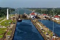
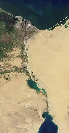
Notable ship canals
Navigability
The standard used in the European Union for classifying the navigability of inland waterways is the European Agreement on Main Inland Waterways of International Importance (AGN) of 1996, adopted by The Inland Transport Committee of the United Nations Economic Commission for Europe (ECE), which defines the following classes:[8][9]
| Class | Tonnage (t) | Draught (m) | Length (m) | Width (m) | Air draught (m) | Description |
|---|---|---|---|---|---|---|
| Class III | 1,000 | |||||
| Class IV | 1,000–1,500 | 2.5 | 80–85 | 9.5 | 5.2–7.0 | Johann Welker[8] |
| Class Va | 1,500–3,000 | 2.5–2.8 | 95–110 | 11.4 | 5.2–7.0–9.1 | Large Rhine[8] |
| Class VIb | 6,400–12,000 | 3.9 | 140 | 15 | 9.1 | [8] |
| Class VII | 14,500–27,000 | 2.5–4.5 | 275–285 | 33.0–34.2 | 9.1 | [8] |
See also
References
- Frederick Augustus Porter Barnard, Arnold Guyot (1883). Johnson's New Universal Cyclopædia. A. J. Johnson & Company. p. 1660. Retrieved 15 June 2020.CS1 maint: uses authors parameter (link)
- Finch, Roy. The Story of the New York State Canals (pdf) (booklet). p. 11. Retrieved 15 June 2020.
- Engineering News and American Railway Journal. Engineering News Publishing Company. 11 November 1897. p. 317,320. Retrieved 15 June 2020.
- "History of canals in Great Britain". www.canalmuseum.org.uk. Archived from the original on 8 October 2019. Retrieved 30 October 2018.
- Harrington, L. (1974). The Grand Canal of China. Bailey and Swinfen. p. 11. Retrieved 4 July 2020.
- "Canals 1750 to 1900 – History Learning Site". History Learning Site. Archived from the original on 30 October 2018. Retrieved 30 October 2018.
- "The Canal Era". www.ushistory.org. Archived from the original on 7 March 2016. Retrieved 30 October 2018.
- "European Agreement on the main Inland Waterways of international importance (AGN)" (PDF). 2072, I-35939. United Nations: 343. Retrieved 30 November 2008. Cite journal requires
|journal=(help) - "UNECE Homepage". www.unece.org. Archived from the original on 15 May 2020. Retrieved 15 June 2020.
External links
 Media related to Canals at Wikimedia Commons