Sierra Madre (Philippines)
The Sierra Madre is the longest mountain range in the Philippines. Spanning over 540 kilometers (340 mi), it runs from the province of Cagayan down to the province of Quezon, forming a north–south direction on the eastern portion of Luzon, the largest island of the archipelago. It is bordered by the Pacific Ocean to the east, Cagayan Valley to the northwest, Central Luzon to the midwest, and Calabarzon to the southwest. Some communities east of the mountain range, along the coast, are less developed and so remote that they could only be accessed by taking a plane or a boat.[1]
| Sierra Madre | |
|---|---|
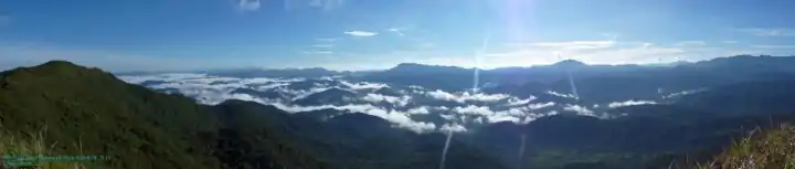
 View south of the northern Sierra Madre from the peak of Mount Cagua in Cagayan | |
| Highest point | |
| Peak | Mount Guiwan |
| Elevation | 1,915 m (6,283 ft) |
| Dimensions | |
| Length | 540 km (340 mi) North to south |
| Width | 56 km (35 mi) east to west |
| Area | 16,260 km2 (6,280 sq mi) |
| Geography | |
.svg.png.webp) Location of the center of the range in the Philippines | |
| Country | Philippines |
| Province | |
| Region | |
| Range coordinates | 16°3′N 121°35′E (approximate center of the range) |
| Borders on | Pacific Ocean |
The country's largest protected area, the Northern Sierra Madre Natural Park, is situated at the northern part of the range in the province of Isabela. The park is in the UNESCO tentative list for World Heritage List inscription. Environmentalists, scholars, and scientists have been urging the government to include the other parks within the Sierra Madre mountains for a UNESCO site that would encompass the entire mountain range from Cagayan to Quezon.[2]
Geography
In the north, the range starts in the province of Cagayan and ends in the south in the province of Quezon. In the province of Nueva Vizcaya, the Caraballo Mountains lies between Sierra Madre and Cordillera Central.
The mountain range serves as a typhoon barrier, attenuating incoming typhoons from the Pacific Ocean before reaching the central mainland.[3]
Elevation
The range's highest point is unclear, and several peaks are attributed as the highest. Mount Anacuao in Aurora province stands at 6,069 feet (1,850 m), while Mount Cetaceo in Cagayan is of similar altitude. However, an expedition in September and October 2012 to Mount Guiwan (Nueva Vizcaya) preliminarily measured an altitude of 6,283 feet (1,915 m) on the summit.[4]
Peaks
List of highest peaks along the mountain range by elevation.
- Mount Guiwan – 6,283 ft (1,915 m)
- Mount Mingan – 6,191 ft (1,887 m)
- Mount Anacuao – 6,869 ft (2,094 m)
- Mount Cetaceo – 5,981 ft (1,823 m)
- Mount Dos Cuernos – 5,856 ft (1,785 m)
- Salakot Peak – 5,699 ft (1,737 m)
- Mount Kiligantian – 5,490 ft (1,670 m)
- Mount Cresta – 5,062 ft (1,543 m)
- Mount San Cristobal – 4,882 ft (1,488 m)
- Mount Otunao – 4,803 ft (1,464 m)
- Mount Irid – 4,751 ft (1,448 m)
- Mount Batay – 4,596 ft (1,401 m)
- Mount Dos Hermanos – 4,557 ft (1,389 m)
- Mount Minalunad – 4,419 ft (1,347 m)
- Mount Oriod – 3,957 ft (1,206 m)
- Mount Palanan – 3,921 ft (1,195 m)
- Mount Cagua – 3,717 ft (1,133 m)
- Mount Etnora – 3,671 ft (1,119 m)
- Mount Lubog – 3,133 ft (955 m)
- Mount Sumag – 2,759 ft (841 m)
- Mount Batolusong 2,559 ft (780 m)
- Mount Mapalad 2,461 ft (750 m)
- Mount Daraitan – 2,425 ft (739 m)
- Mount Maynoba – 2,388 ft (728 m)
- Mount Masungki – 2,165 ft (660 m)
- Mount Binutasan – 1,844 ft (562 m)
- Mount Malauban – 1,024 ft (312 m)
Rivers
List of major rivers along the mountain range by length.
- Cagayan River 518 km (322 miles)
- Pampanga River 270 km (167.7 miles)
- Ilagan River 189 km (117 miles)
- Angat River 153 km ( 95 miles )
- Agos River 93.8 km ( 58.2 miles )
- Pinacanauan River 82.6 km (51.3 mi)
- Umiray River 80.6 km (50 miles)
- Palanan River 79 km (49 miles)
- Marikina River 78 km (48.2 miles)
- Abuan River 70 km (43.4 miles)
- Aguang River 52 km (32.3 miles)
- Kaliwa River 31.3 km (19.4 miles)
List of waterfalls in Sierra Madre
- Daranak Falls, Tanay
- Eva Falls, Dona R. Trinidad
- Lucab Falls, Dona R. Trinidad
- Secret Falls, Dona R. Trinidad
- Talon Pari Falls, Dona R. Trinidad
- Talon Pedro Falls, Dona R. Trinidad
- 13th Falls, Dona R. Trinidad
- Verdivia Falls, Dona R. Trinidad
- Zamora Falls, Dona R. Trinidad
Ecoregions
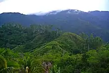
Two ecoregions cover the Sierra Madre. The Luzon rain forests cover the lower slopes of the range, and are characterized by dipterocarp trees. The Luzon montane rain forests cover the portions of the range above 1000 meters elevation, and are characterized by laurel forests of oak and laurel trees.
Other protected areas
- Amro River Protected Landscape
- Angat Watershed Forest Reserve
- Casecnan Protected Landscape
- Dinadiawan River Protected Landscape
- La Mesa Watershed Reservation
- Magapit Protected Landscape
- Northern Sierra Madre Natural Park
- Pantabangan–Carranglan Watershed Forest Reserve
- Peñablanca Protected Landscape and Seascape
- Quezon Protected Landscape
- Quirino Protected Landscape
- Simbahan-Talagas Protected Landscape
- Talaytay Protected Landscape
- Upper Marikina River Basin Protected Landscape
Active volcanoes
- Cagua Volcano, an active volcano in Cagayan province that last erupted in 1907.
Remote communities
Some coastal communities east of the Sierra Madre Mountains, especially from Palanan, Isabela heading north to near the northernmost tip of mainland Cagayan, are remote and isolated with no roads connecting them to towns west of the mountain range. Towns like Palanan, Divilacan and Maconacon, Isabela can only be reached by plane from Cauayan City or a boat ride from Aurora province, south of Isabela or from Santa Ana, Cagayan, north of the province. Ilagan City – Divilacan road traversing the Sierra Madre mountain is about to be completed.[5]
Endemic species
Flora
Northern Sierra Madre Natural Park, the largest protected area in Sierra Madre range, is home to dipterocarp trees belonging to Hopea and Shorea family, orchids such as Dendrobium aclinia, the leguminous tree, Milletia longipes and a member of the citrus family, Swinglea glutinosa.[6]
Fauna
In the forest, in April 2010, the endemic lizard species Northern Sierra Madre Forest monitor lizard – Varanus bitatawa (common name: Butikaw) was described to science, although the Aeta and Ilongot indigenous peoples have known and used it as a food source. The Northern Sierra Madre Forest monitor lizard is one of the three frugivorous lizards in the Varanidae family along with V. olivaceus and V. mabitang. All of the three frugivorous lizards are found only in the Philippines.[7]
Endemic mammals in Sierra Madre are the Sierra Madre shrew mouse and Sierra Madre forest mouse.[8]
Non-endemic species
Flora
Narra, the national tree of the Philippines, Almaciga, and Kamagong can be found in Sierra Madre range.[9]
Fauna
Isabela oriole, Philippine Eagle, and Philippine Crocodile are critically endangered species that can be found in fragmented locations.[9]
Human activities
Forest-loss due to anthropogenic activities
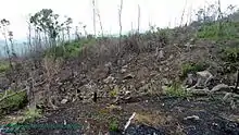
The Sierra Madre mountain range forest habitat is threatened by human activities. Settlers living at the lower portions of the slopes generally are supported by work in logging and charcoal-making. Some portions of the forest cover are already second growth forest. Forest degradation of at least 1,400 hectares per year caused by illegal tree cutting, slash and burn farming, fuel-wood collection, illegal hunting, and residential expansion.[9]
Mining
A gold and copper mine in the municipality of Kasibu, Nueva Vizcaya has been operated by the OceanaGold Corporation based in Australia. The Didipo mine is a large-scale open-pit mine in a remote location, and local residents claim the company has severely damaged both the environment for miles around the site, and suppressed the long-standing farming economy.[10] Oceana contintinues to assert a right to operate despite expiration of its permit, and opposition by organized local residents, the Catholic Church, and worldwide environmental groups.[11]
Hydropower project
The Kaliwa dam project through a project called "New Centennial Water Source" in Sitio Cablao, Brgy. Pagsangahan, General Nakar, Quezon / Sitio Queborosa, Brgy. Magsaysay, Infanta, Quezon is threatening the endangered species living in the sparse remaining forest of Sierra Madre and indigenous people's lives in that area.[12] This project replaced the Kaliwa Low Dam that did not materialize and under the new administration, Rodrigo Duterte approved the Chinese-funded proposal. Aside from the destruction of ecologically-important forests, the dam also faces controversy for fulfillment of financial requirement through a Chinese loan with 2.0% interest rate than Japanese loan with 1.25% interest rate.[13] The project continues to face strong opposition from the public yet the government is eager to continue.[14]
References
- U.S. Coast and Geodetic Survey (1919). "United States Coast Pilot Philippine Islands Part 1", pg. 44. Government Printing Office, Washington.
- Coursey, Oscar William (1903). History and Geography of the Philippine Islands. Educator School Supply Company.
- Bordadora, Norman (November 12, 2006). "Sierra Madre blocks 'Queenie' punch". Philippine Daily Inquirer. Archived from the original on December 25, 2014. Retrieved December 25, 2014.
- Gray, Shirley (2003). The Philippines. Children's Press. ISBN 978-0-516-24212-5.
- Christian (June 13, 2011). "Palanan and Maconacon". Off the Beaten Track in the Philippines. Retrieved on 2014-09-28.
- Centre, UNESCO World Heritage. "Northern Sierra Madre Natural Park and outlying areas inclusive of the buffer zone". UNESCO World Heritage Centre.
- Welton, L. J.; Siler, C. D.; Bennett, D.; Diesmos, A.; Duya, M. R.; Dugay, R.; Rico, E. L. B.; Van Weerd, M.; Brown, R. M. (2010). "A spectacular new Philippine monitor lizard reveals a hidden biogeographic boundary and a novel flagship species for conservation". Biology Letters. 6 (5): 654–658. doi:10.1098/rsbl.2010.0119. ISSN 1744-9561. PMC 2936141. PMID 20375042.
- Heaney, L.R.; Balete, D.S.; Veluz, M.J.; Steppan, S.J.; Esseltyn, J.A.; Pfeiffer, A.W.; Rickart, E.A. (2014). "Two new species of Philippine forest mice (Apomys, Muridae, Rodentia) from Lubang and Luzon Islands, with a redescription of Apomys sacobianus Johnson, 1962". Proceedings of the Biological Society of Washington. 126 (4): 395–413. doi:10.2988/0006-324X-126.4.395. S2CID 49347286.
- "Gold mining policy chaos in Philippines". Asia Times. March 1, 2020.
- "Standoff over Philippines' Didipio mines escalates despite COVID-19 lockdown". Mongabay Environmental News. April 6, 2020.
- "Kaliwa Dam will destroy Sierra Madre biodiversity – Haribon Foundation". The Haribon Foundation. November 20, 2018.
- "Japanese firm renews proposal on Kaliwa Dam project". www.pna.gov.ph.
- "The Philippines' China Dam Controversy". thediplomat.com.
- "Mabuwaya - Home". www.mabuwaya.org.
- "Mabuwaya Foundation, Philippines".
External links
| Wikimedia Commons has media related to Sierra Madre (Philippines). |
| Authority control |
|
|---|