Singapore River
The Singapore River (Malay: Sungei Singapura, Chinese: 新加坡河) is a river that runs parallel to Alexandra Road and feeds into the Marina Reservoir in the southern part of Singapore. The immediate upper watershed of the Singapore River is known as the Singapore River Planning Area, although the western part of the watershed is classified under River Valley planning area.
| Singapore River | |
|---|---|
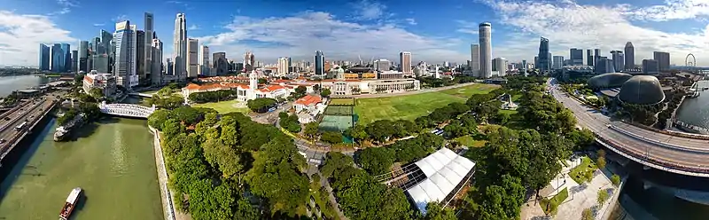
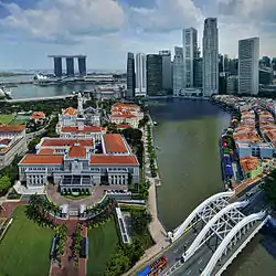 Singapore River flowing through Singapore's central business district | |
.jpg.webp) Early 19th century map of the Singapore River basin | |
| Native name | Sungai Singapura |
| Location | |
| Country | Singapore |
| Physical characteristics | |
| Source | |
| • location | Alexandra Canal |
| Mouth | |
• location | Marina Channel |
| Length | 3.2 km (2.0 mi) |
Singapore River planning area sits within the Central Area of the Central Region of Singapore, as defined by the Urban Redevelopment Authority. The planning area shares boundaries with the following - River Valley and Museum to the south, Tanglin and Bukit Merah to the west, Outram to the south and the Downtown Core to the east.
Geography
The Singapore River is approximately 3.2 kilometers long[1] from its source at Kim Seng Bridge to where it empties into Marina Bay; the river extends more than two kilometers beyond its original source at Kim Seng Bridge as Alexandra Canal, as far as the junction of Commonwealth Avenue.
History
The mouth of the Singapore River was the old Port of Singapore, being naturally sheltered by the southern islands. Historically, the city of Singapore initially grew around the port so the river mouth became the centre of trade, commerce and finance.
At one time, Singapore River was the very lifeblood of the colony, the trade artery, the center of commercial activity, the heart of entrepot trade, the vessel of importance, the capillaries of life and the place which was frequented by the secret societies, the swaylos (Cantonese for coolies who worked on a boat) and the coolies who worked for the philanthropist Tan Tock Seng at Ellenborough Market and the towkay (Hokkien for business owner) Tan Kim Seng who was busy filling his godown with the riches of the East.
Singapore River is where the colourful and surprising history of the river and the myths and legends can still conjure up memories of the lighters, bumboats, tongkangs with their painted eyes to see the danger ahead and sampans of yesteryear. This is where the Malayan princes once sailed and this is where the bullock carts plodded their way up and down each bank as the river found its way to the former rocky river mouth. This is also where an early civilisation was conquered by the Javanese Majapahit Empire, in the year 1376.
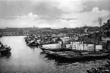
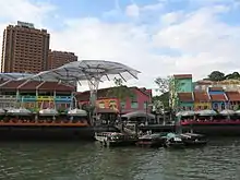
Some of the temples like Yueh Hai Ching Temple and Tan Si Chong Su still stand in the vicinity of the river. Bridges such as Anderson Bridge, Elgin Bridge and Cavenagh Bridge still remain, the Merlion, the shophouses, and the large trees such as Banyan and Madras Thorn. Some parts of this area include quays such as Clarke Quay, Boat Quay and Robertson Quay, which generated trade and extensive demand for services with the boats that landed at the quays. Boat Quay itself was handling three quarters of the shipping service in the 1860s. Shophouses and warehouses flourished around the quays due to their proximity to trade during the colonial era, but presently house various bars, pubs and restaurants, as well as old shops.
The river still borders places where seamen and others, for example, near Raffles Landing Place, made offerings and burned their joss sticks. Poles with streamers flying were once used to tie up the barges as the water lapped against the old stone steps and walls.
Sir Stamford Raffles lost no time after January 1819, when he landed on Singapore River among the orang laut, in bargaining with Temenggong Abdul Rahman, the Temenggong of Johor who then governed the place, having settled in 1811. At the very moment of landing, Raffles must have realised the importance of the river for, in the same year of 1819, the north bank was drained for government buildings, in 1820, the Master Attendant was appointed with an office building to control shipping, and in 1822, the south bank was reclaimed and a retaining wall and steps were built.

Through lack of knowledge or foresight, the bridges were constructed too low and the river was too shallow for the demands that were to be made on its use. This historic river, which Raffles had fashioned from salt marshes, sand bars and mangrove swamps, has witnessed the British rule and the Japanese occupation, and has supported years of economic activity by the Chinese, Malays, Indians and others. However, with the expansion of trade came congestion and pollution.
Old maps of the river state that it actually originates from Bukit Larangan (currently Fort Canning Hill).
Pollution and clean-up
Starting in 1819, there was heavy traffic on the Singapore River due to rapid urbanization and expanding trade.[2] At the same time, it brought in water pollution caused by the disposal of garbage, sewage and other by-products of industries located along the river's banks. The sources of water pollution into the Singapore River and Kallang Basin included waste from pig and duck farms, unsewered premises, street hawkers and vegetable whole sellers. Riverine activities such as transport, boat building and repairs were also found along the Singapore River.
Some 750 lighters plied along the Singapore River and Kallang Basin in 1977. Waste, oil spills and wastewater from these boats and lighters added to the pollution of the rivers. In 1977, Prime Minister Lee Kuan Yew called for a clean up of Singapore's rivers, which included the Singapore River and the Kallang River. The clean up cost the government $300 million and involved a relocation of about 4,000 squatters, along with hawkers and vegetable sellers, whose daily waste flowed into the river. Public housing was found for the squatters, while street hawkers were persuaded to move to hawker centres. The government then dredged foul-smelling mud from the banks and the bottom of the river, clearing the debris and other rubbish.[3]
Despite decades of effort, river cleanup remains a work-in-progress. On 26 November 2017, during a speech at the 60th anniversary of Berita Harian, Prime Minister Lee Hsien Loong urged Singaporeans not to pollute the river with litter and trash.[4]
Singapore River today
The river is now part of the Marina Reservoir after damming the Singapore River at its outlet to the sea to create a new reservoir of freshwater. The dam is known as Marina Barrage.[5]
Whereas the original mouth of the Singapore River emptied into Singapore Straits and its southern islands before major land reclamation took place, the Singapore River now empties into Marina Bay - an area of water partially enclosed by the reclamation work. The Port of Singapore is now located to the west of the island, using most of the south-west coast, and passenger ships to Singapore now typically berth at the Singapore Cruise Centre at Harbourfront. Thus the Singapore River's economic role has shifted away from one that of trade, towards more a role accommodated for tourism and aesthetics for the commercial zone which encloses it.
Sculptures
_by_Aw_Tee_Hong%252C_Cavenagh_Bridge%252C_Singapore_-_20060530.jpg.webp)
There are a number of sculptures along the Singapore River.[6] Many of these depict the life of people living and working along the river during the early days of Singapore.
Notable sculptures include:[7]
- First Generation, made by Chong Fah Cheong
- Fishing at Singapore River, made by Chern Lian Shan
- The River Merchants, made by Aw Tee Hong
- A Great Emporium, made by Malcolm Koh
- From Chettiars to Financiers, made by Chern Lian Shan
- Singapura Cats, made by various artists
Bridges and tunnels
Between 1819, when the first wooden jetty and the first bridge were built over the Singapore River in Singapore, and in 2015, 14 bridges were built across the river (or 17, although Marina Reservoir, where the estuary is now located, is considered a Singapore River). Until 1819, the river could only be crossed by boats and ferries. Some of the bridges were demolished and rebuilt or their purpose was changed (traffic bridge in pedestrian bridge and the like).
Former records from Singapore show a simple wooden bridge over the river from 1819, which had no name, and is considered the first bridge in the city. In 1822, the bridge was replaced by a wooden bridge, the Presentment Bridge, from which later (1862 and 1927) today's Elgin Bridge emerged. In the years that followed, other bridges such as Coleman Bridge (1840), Kim Seng Bridge (1862), Cavenagh Bridge (1869) or Read Bridge (1889) were added. The most recent bridges are the Helix Bridge (2010), Bayfront Bridge (2010) and the Jubilee Bridge (2015).
- Kim Seng Bridge (1862)
- Jiak Kim Bridge (1999)
- Robertson Bridge (1998)
- Pulau Saigon Bridge (1890)
- Alkaff Bridge (1999)
- Clemenceau Bridge (1940)
- Downtown MRT Line between Fort Canning and Chinatown (2017)
- Ord Bridge (1886)
- Read Bridge (1889)
- North East MRT Line between Clarke Quay and Dhoby Ghaut (2003)
- Coleman Bridge (1840/1985)
- Elgin Bridge (1819/1922)
- Cavenagh Bridge (1870)
- East West MRT Line and North South MRT Line between City Hall and Raffles Place (1987/1989)
- Anderson Bridge (1910)
- Esplanade Bridge (1997)
- Jubilee Bridge (2015)
- Helix Bridge (2010)
- Downtown MRT Line and Circle MRT Line between Promenade and Bayfront (2012)
- Bayfront Bridge (2010)
- Benjamin Sheares Bridge (1981)
References
| Library resources about Singapore River |
- Leary, Michael E.; McCarthy, John (2013-10-30). The Routledge Companion to Urban Regeneration. Routledge. p. 132. ISBN 9781136266546.
- "Singapore River". Heritage Trails. Archived from the original on 2009-08-22. Retrieved 2010-04-01.
- migration (2014-07-04). "5 interesting facts about the Singapore River clean-up". Retrieved 2016-07-09.
- http://www.straitstimes.com/singapore/river-cleanup-is-never-done-singaporeans-must-still-learn-not-to-litter-pm-lee-hsien-loong
- "PUB annual report: Birth of the barrage". PUB. 2008. Archived from the original on 7 April 2015. Retrieved 29 September 2016.
- "Sir Stamford Raffles statue and other sculptures along Singapore River to be cleaned next week". The Straits Times. Singapore. 3 February 2015. Retrieved 2015-11-23.
- Ang, Benson (18 September 2016). "Sculptures by the Singapore River get a spruce up". The Straits Times. Retrieved 19 September 2016.
External links
 Media related to Singapore River at Wikimedia Commons
 Singapore River travel guide from Wikivoyage