Marina Bay, Singapore
Marina Bay is a bay located in the Central Area of Singapore, surrounded by the perimeter of four other planning areas, the Downtown Core, Marina East, Marina South and Straits View. The area surrounding the bay itself, also called Marina Bay, is a 360 hectare extension to the adjacent Central Business District. It is also considered the 'newer' downtown of Singapore, as it is mostly built on reclaimed land from the Singapore River during the late 1960s and early 1970s.[1]
Marina Bay | |
|---|---|
.jpeg.webp) | |
 Aerial view (top) Gardens by the Bay within the district (bottom) | |
Location in Singapore | |
| Coordinates: 1°17′04″N 103°51′21″E | |
| Country | |
| Planning Area | Central Area |
| Boundaries | Marina Coastal Expressway, Marina Boulevard |
| Rail services | North South, Circle, Downtown and Thomson-East Coast Lines at Bayfront, Downtown, Gardens by the Bay (2021), Marina Bay, Marina South (2021), Marina South Pier and Promenade stations |
| Historical features. | Anderson Bridge Benjamin Sheares Bridge Marina Bay Sands Marina Bay Street Circuit Gardens by the Bay Singapore Flyer Suntec City |
Buildings include Gardens by the Bay, the Marina Bay Sands, Marina Bay Financial Centre, The Sail @ Marina Bay, Marina One and Suntec City. It is also where the grandstand and pit building of the Marina Bay Street Circuit is located, where it is most commonly used for the Singapore Grand Prix.
History
In 1969, land reclamation work to create 360 hectares of prime waterfront site began at Marina Bay. The reclaimed land forms what is today the Marina Centre and Marina South areas, and the reclamation work was completed in 1992.[2][3][4] In the reclamation process, Telok Ayer Basin and Inner Roads was removed from the map by reclaiming land, while the Singapore River's mouth now flows into the bay instead of directly into the sea.
The long term visions for the Marina Bay area was first articulated in the 1983 Master Plan by the URA, with the waterfront areas being deliberately kept open to the public.[2] In 1988, the draft plan for Marina Bay was presented to the public in a two-week exhibition where it set out the objectives for the development, among which are optimising the waterfront location and creating a distinctive image with international landmarks that could become a focal point for the city.[5]
The Urban Redevelopment Authority (URA) Master Plan for Marina Bay aims to encourage a mix of uses for this area, including commercial, residential, hotel and entertainment and to turn it into a work-live-play vibrant 24-hour CBD. In 2005, the Urban Redevelopment Authority spent $400,000 on a branding exercise to name the Marina Bay area in order to sell the new major developments in the area, only to settle with the original name "Marina Bay".[6][7]
The Singapore government also spent $35 million to complete the 3.5 km Waterfront Promenade around Marina Bay.[8] It includes a new eco-friendly visitor centre and The Helix linking Bayfront to Marina Centre where the Youth Olympic Park is located. The Promontory @ Marina Bay (formerly Central Promontory Site) will be used as an interim event and public space used for activities such as theatres and carnivals.[9]
In 2008, Marina Barrage was built, converting the basin into a freshwater Marina Reservoir.
Events at Marina Bay
The Formula One Singapore Grand Prix has taken place annually since 2008 on a street circuit adjacent to Marina Bay.[10] Since its construction in 2007, The Float@Marina Bay has hosted events such as the National Day Parade, New Year's Eve Countdown[11] and Singapore Fireworks Celebrations, and also serves as a spectator stand for the Singapore Grand Prix. Furthermore, it also played host to the Opening and Closing Ceremonies of the inaugural 2010 Summer Youth Olympics.[12]
The area also hosts the annual i Light Marina Bay, a sustainable light art festival.
The event space next to Marina Bay Sands, known as The Lawn, hosted the first overseas and Singapore edition of ArtBox Bangkok on two separate weekends, 14–16 April and 21–23 April 2017.[13][14]
Infrastructure
Common Services Tunnel
The Common Services Tunnel is a development of the Marina Bay area in Singapore. It is said to be the second of its kind in Asia after Japan. This utility tunnel will house telecom cables, power lines, water pipes as well as provision for pneumatic refuse collection pipes.[15] The 1.4-kilometre (4,600 ft) phase one of the tunnel has cost about S$81 million (about US$51 million) while the 1.6-kilometre (5,200 ft) phase two, which is under construction and scheduled to be ready in 2010, will cost S$137 million (about US$86 million).
A District Cooling Plant is also commissioned in May 2010,[16] which will supply chilled water for the air-conditioning of buildings in the area through pipes housed within the tunnel, according to the report. Built at a cost of some S$110 million (about US$69 million), the District Cooling Plant will be able to serve 1.25 million square metres of gross floor area and free up space which should be used for building chiller plants and cooling towers for separate buildings. The District Cooling Plant started operations on 3 March 2016.[17] The Singapore government is pumping in nearly S$2 billion (about US$1.2 billion) to build the infrastructural base for Marina Bay, which also includes the Marina Barrage, a Rapid Transit System and the new Marina Promenade and Double Helix Bridge.
Water management
In 2004, the Public Utilities Board announced plans to construct a new downtown reservoir by damming the Marina Channel. This barrage was completed in 2008. Known as the Marina Barrage, it turned Marina Bay and the Kallang Basin into a confined freshwater reservoir with limited access to marine transportation to regulate the water quality. The new reservoir provides another source of drinking water for Singapore, as well as a stable water level for a variety of water activities and events. The barrage will also prevent flooding in the Chinatown area.
Transport
There are currently 8 rail stations: City Hall, Raffles Place, Marina Bay, Bayfront, Downtown, Telok Ayer, Esplanade and Promenade serving Marina Bay. By 2020, the 360 hectares Marina Bay will boast a comprehensive transport network as Singapore's most rail-connected district.[18] The first three new MRT lines (Circle Line, Downtown Line) opened between 2012 and 2014. By 2018, the Marina Bay district had more than six MRT stations, all no more than five minutes of each other. In the future, the Thomson Line will create better connections within Marina South. A pedestrian network links developments and MRT stations.[19] Within greater Marina Bay, water taxis will even double up as an alternative mode of transport.
Key developments
In Marina Bay
- ArtScience Museum
- Asia Square
- Bayfront Bridge
- Circle line
- Clifford Pier
- Common Services Tunnel
- Downtown line
- Esplanade – Theatres on the Bay
- F1 Pit Building
- Gardens by the Bay
- Marina Bay Street Circuit
- The Fullerton Heritage Precinct: Customs House, The Fullerton Hotel Singapore, The Fullerton Waterboat House, One Fullerton, Fullerton Bay Hotel
- The Helix Bridge
- Marina Barrage
- Marina Bay Cruise Centre Singapore
- Marina Bay Financial Centre
- Marina Bay Golf Course
- Marina Bay Link Mall
- Marina Bay MRT station
- Marina Bay Sands
- Marina Bay Suites
- Marina Coastal Expressway
- Marina South Pier
- Marina South Pier MRT station
- Marina Square
- Millenia Walk
- North South line
- One Marina Boulevard
- One Raffles Quay
- One Shenton Way
- OUE Bayfront
- Singapore Flyer
- Suntec City
- The Float at Marina Bay
- The Lawn @ Marina Bay
- The Promontory @ Marina Bay (formerly Central Promontory Site)
- The Sail @ Marina Bay
- Thomson–East Coast line
- Youth Olympic Park
Other places of interest
- The 101-hectare Gardens by the Bay site is made up of Bay South Garden, Bay East Garden, and Bay Central Garden across the mouth of the Singapore River. All three gardens will be interconnected via a series of pedestrian bridges to form a larger loop along the whole waterfront and linked to surrounding developments, open public spaces, transport nodes and attractions.
- A 3.5 km waterfront promenade linking the attractions at the Marina Centre, Collyer Quay and Bayfront areas was completed in 2010.
In popular culture
- In the movie Independence Day: Resurgence, Marina Bay was destroyed by an alien spacecraft.[20]
- Marina Bay and its landmarks was featured in the 2018 American–Singaporean film Crazy Rich Asians, both in a scenic B-roll of Singapore, as well as a setting towards the end of the film.
Gallery
 Marina Bay and Marina Centre at night.
 Marina Bay with the skyline of Raffles Place on 31 December 2006.
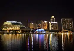
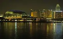 Marina Bay with the Esplanade Theatres behind on 30 November 2007
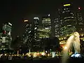 Singapore Downtown Core near Marina Bay on 30 November 2007
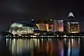
 Performing Arts Centre, Marina Bay
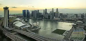
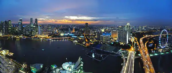 Aerial view of Marina Bay in the evening
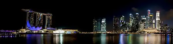 Ground level view of Marina Bay at night
References
- "Vision". Marina Bay Singapore 2014. Archived from the original on 4 September 2015. Retrieved 19 March 2014.
- June Gwee, ed. (2013). Case Studies in Public Governance: Building Institutions in Singapore. Taylor & Francis Ebooks. ISBN 9781136447075.
- Ching Tuan Yee and Benjamin Ng. "Marina Bay: The Shape of Things to Come". Civil Service College.
- Collin Anderson (2016). DP Architects on Marina Bay: Designing for Reclaimed Lands. Oro Editions. ISBN 9781941806975.
- Tan Chung Hong (1991). "Planning for the Development of Singapore's Urban Waterfront". In Lin Sien Chia, L. M. Chou (ed.). Urban Coastal Area Management: The Experience of Singapore (PDF). International Specialized Book Services. pp. 54–56. ISBN 9789711022877.
- "Singapore spends $400,000 to rename Marina Bay... Marina Bay". Agence France-Presse. 22 July 2005.
- "Compass Point renamed twice: Other names in Singapore that drew flak". The Straits Times. 23 December 2015.
- "$35m for Marina Bay waterfront promenade". Asiaone. 19 September 2008. Retrieved 3 June 2010.
- "Downtown @ Marina Bay". URA. http://www.ura.gov.sg/cudd/cawebsite/downtown-map.htm Archived 14 May 2011 at the Wayback Machine Retrieved 2010-07-08.
- "Singapore to host F1 Grand Prix next year". Channel NewsAsia. 11 May 2006. Retrieved 11 May 2007.
- "Marina Bay Singapore Countdown".
- "Marina Bay Floating Stadium". Archived from the original on 9 January 2010. Retrieved 14 July 2010.
- "What to expect at Artbox Singapore: the first overseas edition of Bangkok's famous market". Coconuts Singapore. Retrieved 21 April 2017.
- "Attention hipsters: Artbox Bangkok is coming to Singapore". AsiaOne. Retrieved 21 April 2017.
- "Parliament Briefs : Common Services Tunnels Bill passed". Retrieved 17 January 2019.
- "Cooling & Heating". Retrieved 14 August 2019.
- "World's biggest underground district cooling network now at Marina Bay". Retrieved 14 August 2019.
- "5 MRT lines to Marina Bay". The Straits Times. 24 May 2010. Retrieved 3 June 2010.
- "Seamless Connectivity". Marina Bay Singapore. 2008. http://www.marina-bay.sg/connectivity.html. Retrieved 2010-06-03.
- Hui Min, Chew (9 February 2016). "Singapore skyline 'destroyed' in trailer for movie Independence Day: Resurgence". The Straits Times. Retrieved 9 June 2017.
External links
| Authority control |
|
|---|