Sinntal
Sinntal is a municipality in the Main-Kinzig district, in Hesse, Germany. It has a population of around 8,900.
Sinntal | |
|---|---|
 Coat of arms | |
Location of Sinntal within Main-Kinzig-Kreis district 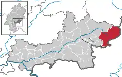 | |
 Sinntal  Sinntal | |
| Coordinates: 50°16′N 9°38′E | |
| Country | Germany |
| State | Hesse |
| Admin. region | Darmstadt |
| District | Main-Kinzig-Kreis |
| Subdivisions | 12 districts |
| Government | |
| • Mayor | Carsten Ullrich |
| Area | |
| • Total | 111.83 km2 (43.18 sq mi) |
| Highest elevation | 585 m (1,919 ft) |
| Lowest elevation | 220 m (720 ft) |
| Population (2019-12-31)[1] | |
| • Total | 8,856 |
| • Density | 79/km2 (210/sq mi) |
| Time zone | UTC+01:00 (CET) |
| • Summer (DST) | UTC+02:00 (CEST) |
| Postal codes | 36391 |
| Dialling codes | 06664, 06665 (Altengronau, Jossa, Neuengronau), 09741 (Züntersbach) |
| Vehicle registration | MKK, GN, SLÜ |
| Website | www.sinntal.de |
Geography
Location
Sinntal is located around 30 km south of Fulda in the Main-Kinzig district of Hesse.
The municipal territory lies at elevations between 220 and 585 m above NHN. It includes area in the Mittelgebirge Spessart and Rhön.[2]
Sinntal is located right at the border between Hesse and Bavaria. It stretches across the valley of the Sinn river from which it takes its name.
Subdivisions
Sinntal consists of the following Ortsteile:
- Altengronau
- Breunings
- Jossa
- Mottgers
- Neuengronau
- Oberzell with Ziegelhütte
- Sannerz
- Schwarzenfels
- Sterbfritz (seat of the municipal administration)
- Weichersbach
- Weiperz
- Züntersbach
Neighbouring communities
Sinntal borders on (from the north, clockwise): Kalbach (Hesse), Motten, the unincorporated area Mottener Forst-Süd, Bad Brückenau, Zeitlofs, the unincorporated area Roßbacher Forst, Obersinn (all Bavaria), the unincorporated area Gutsbezirk Spessart (Hesse) and Schlüchtern (Hesse).
Governance
The mayor of Sinntal is Carsten Ullrich.
Infrastructure
Transport
Sinntal lies on the Hanover-Würzburg high-speed rail line. Germany's longest tunnel, the Landrücken Tunnel is located in the northern part of the municipal territory.
The closest motorway is the Bundesautobahn 7. The nearest interchange is "Bad Brückenau".
References
- "Bevölkerungsstand am 31.12.2019". Hessisches Statistisches Landesamt (in German). July 2020.
- "Daten und Anfahrt (German)". Gemeinde Sinntal. Retrieved 8 April 2016.
External links
| Wikimedia Commons has media related to Sinntal. |
- Official website
 (in German)
Towns and municipalities in Main-Kinzig-Kreis district | ||
|---|---|---|
| Wappen des Landkreises Main-Kinzig-Kreis | |