Siwana
Siwana is a Tehsil in Barmer district in Indian state of Rajasthan, located 151 km from Barmer. The place is known for its fort which is locally known as Gadh Siwana, Gadh means Fort. Siwana have 130 villages. total Population as per 2001 census is 213,648,[1] 111,155 male and 102,493 female. Siwana is nearest city Balotara 35 km from siwana.
Siwana
Gadh Siwana (Gadh = Fort) | |
|---|---|
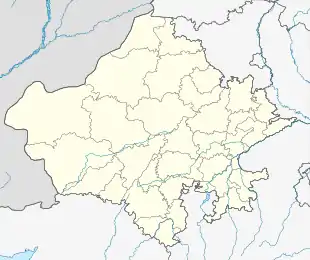 Siwana Location in Rajasthan, India  Siwana Siwana (India) | |
| Coordinates: 25°37′59″N 72°25′0″E | |
| Country | |
| State | Rajasthan |
| District | Barmer district |
| Government | |
| • Body | Tehsil and Sub Division |
| Elevation | 184 m (604 ft) |
| Population | |
| • Total | 213,648 |
| Languages | |
| • Official | Hindi& Marwari [Siwanchi] |
| Time zone | UTC+5:30 (IST) |
| PIN | 344044 |
| Telephone code | +912901 |
| Vehicle registration | RJ-39 |
| Nearest city | Balotra |
| Lok Sabha constituency | Barmer (Lok Sabha constituency) |
| Vidhan Sabha constituency | Siwana |
| Civic agency | TEHSIL |
| Website | www |
Fort
The ruined Siwana fort (Gadh Siwana) is situated on a hilltop. According to bardic tradition, Siwana was established by Vira-narayana, a son of the 11th century Paramara king Bhoja.[2]
In 1308, Alauddin Khalji of Delhi Sultanate defeated Sitala Deva, the local ruler. To commemorate Sitala Deva's heroic defence of the fort, an annual fair called the Kalyan Singh Ka Mela is still held within the precincts of the fort in the month of Shraavana (July-Aug). Later, in the period 1318-20, Luntiga Chauhan stormed the fort of Siwana and slaughtered its Muslim garrison. It was later captured by the Rathors of Marwar and remained a part of Marwar till independence of India. Siwana was the capital of Rao Chandrasen Rathore when he had opposed the Mughal emperor. Siwana was captured by Padshah Akbar in 1576, but was later restored to Raja Udai Singh of Marwar.
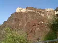 Fort view from below
 View of fort during Upstairs
 Down View of the village from the fort.
.jpg.webp) Lake - Gadh Siwana ( Fort)
Lake - Gadh Siwana ( Fort) Inside broken portion Gadh Siwana - Fort
 Entry of Fort from the top of Fort - Gadh Siwana
 Down Stairs from the Fort - Gadh Siwana
Geography
The city lies in between mountains of Aravali Ranges on around. The only one of biggest Dam of Barmer district Meli bandh is at 7 km from Siwana. The main occupation is farming. Bajra (pearl millet), Moong (greengram), Til (seasamum) & jowar(sorghum) are main Productions in Rainy season. Jeera(Cumin), Erendi(Castor), Mustard & veggies in winter are mainly the yields .
Recently due to exploitation of water and unorganised measures to harvest rainwater the area has a serious water problem. Siwana is also known for mines producing granite.
Tourism
Ashapurna temple, It is a large temple made of white marble.
Baba Ramdev Temple, It is a temple also made of white marble.
Manch Guru Temple, It is an old samadhi temple lies which has live samadhis of Four great saints who lived there.
Bheem Goda, Hinglaj Mata Temple, Ushtradevi and Haldeshwar temples are other attractions near Siwana.
Ramdev ji ki beri, kuship, is a Holy place situated between the aravali parvatamala.
Hinglaj Mata temple situated in Than village, 10 km from Siwana city centre of Gandhi Chowk. This is one of the most revered Hinglaj Mata temple in India after Pakistan.
Administration
The present MLA of Siwana is Hameer Singh Bhayal from BJP who defeated Nirmal Daas from Congress.
References
- http://www.censusindia.gov.in/PopulationFinder/Sub_Districts_Master.aspx?state_code=08&district_code=17
- Manjit Singh Ahluwalia (1978). Muslim Expansion in Rajasthan: The Relations of Delhi Sultanate with Rajasthan, 1206-1526. Yugantar. p. 107.