Barmer, Rajasthan
Barmer is the district headquarters of the Barmer district in the state of Rajasthan, India. It is a Group 'C' city for living standards, and the headquarters of the Barmer Taluka.
Barmer | |
|---|---|
[[Metropolitan
City]] | |
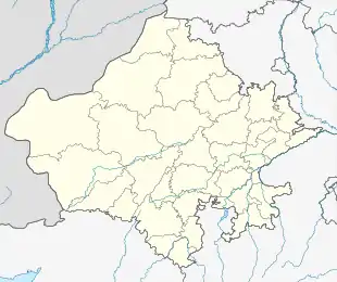 Barmer Location in Rajasthan, India  Barmer Barmer (India) | |
| Coordinates: 25.75°N 71.38°E | |
| Country | |
| State | Rajasthan |
| District | Barmer |
| Founded by | Mallinath |
| Government | |
| • Type | Democratic |
| • Body | BMC |
| • District Collector & District Magistrate | Vishram Meena, IAS |
| • Superintendent of Police | Anand Sharma, IPS |
| • Chief Executive Officer Zila Parishad | Mohan Dan Ratnu, RAS [1] |
| Area | |
| • [[Metropolitan City]] | 28,387 km2 (10,960 sq mi) |
| Area rank | No. 5 |
| Elevation | 227 m (745 ft) |
| Population (2011) | |
| • [[Metropolitan City]] | 100,015 |
| • Metro | 184,000 |
| Languages | |
| • Official | Hindi, Marwadi |
| Time zone | UTC+5:30 (IST) |
| PIN | 344001 |
| ISO 3166 code | RJ-IN |
| Vehicle registration | RJ-04 |
| Website | barmer |
Demographics
As of the 2011 Census, Barmer had a population of 100,051. The population of the 0-6 year age range was 22% of the total population. Barmer had an average literacy rate of 56.53%; gender-wise, 70% of males and 30% of females are literate.[2]
Transportation
Barmer has two national highways crossing it — NH 15 and NH 112. It has direct trains to Jodhpur (Rajasthan), New Delhi, Bengaluru (Karnataka), Haridwar (Uttarakhand), and Guwahati (Assam) among others.
Geography
This district is Spread across an area of 28,387 km2 . Barmer district is the third largest district of Rajasthan State. This district is famous for its vegetation like khejari, ber, ker, and sangari. It is located between 24°58' and 26°32' N and between 70°05' and 72°52' E. The district forms a part of the Thar desert and is situated in the western part of the State.
Climate
| Climate data for Barmer, Rajasthan (1981–2010, extremes 1932–2012) | |||||||||||||
|---|---|---|---|---|---|---|---|---|---|---|---|---|---|
| Month | Jan | Feb | Mar | Apr | May | Jun | Jul | Aug | Sep | Oct | Nov | Dec | Year |
| Record high °C (°F) | 36.6 (97.9) |
39.4 (102.9) |
43.3 (109.9) |
48.3 (118.9) |
49.9 (121.8) |
48.7 (119.7) |
45.5 (113.9) |
43.7 (110.7) |
43.2 (109.8) |
43.1 (109.6) |
39.4 (102.9) |
35.2 (95.4) |
49.9 (121.8) |
| Average high °C (°F) | 25.8 (78.4) |
29.1 (84.4) |
34.7 (94.5) |
39.3 (102.7) |
42.0 (107.6) |
40.7 (105.3) |
37.0 (98.6) |
35.1 (95.2) |
36.5 (97.7) |
37.0 (98.6) |
32.3 (90.1) |
27.4 (81.3) |
34.7 (94.5) |
| Average low °C (°F) | 10.4 (50.7) |
13.3 (55.9) |
19.1 (66.4) |
24.1 (75.4) |
26.9 (80.4) |
27.8 (82.0) |
26.9 (80.4) |
25.7 (78.3) |
25.0 (77.0) |
22.2 (72.0) |
16.3 (61.3) |
11.7 (53.1) |
20.8 (69.4) |
| Record low °C (°F) | −1.7 (28.9) |
3.8 (38.8) |
4.5 (40.1) |
12.2 (54.0) |
16.7 (62.1) |
16.2 (61.2) |
19.4 (66.9) |
20.0 (68.0) |
16.7 (62.1) |
13.9 (57.0) |
6.7 (44.1) |
2.3 (36.1) |
−1.7 (28.9) |
| Average rainfall mm (inches) | 1.3 (0.05) |
2.4 (0.09) |
1.8 (0.07) |
2.8 (0.11) |
9.8 (0.39) |
25.8 (1.02) |
90.1 (3.55) |
103.0 (4.06) |
33.2 (1.31) |
3.8 (0.15) |
1.2 (0.05) |
0.5 (0.02) |
275.8 (10.86) |
| Average rainy days | 0.2 | 0.3 | 0.2 | 0.4 | 0.8 | 1.4 | 4.3 | 4.3 | 1.9 | 0.4 | 0.2 | 0.2 | 14.7 |
| Average relative humidity (%) (at 17:30 IST) | 30 | 25 | 21 | 19 | 22 | 33 | 48 | 54 | 43 | 28 | 30 | 32 | 32 |
| Source: India Meteorological Department[3][4] | |||||||||||||
References
- "Barmer District Administration".
- "Census of India 2001: Data from the 2001 Census, including cities, villages and towns (Provisional)". Census Commission of India. Archived from the original on 16 June 2004. Retrieved 1 November 2008.
- "Station: Barmer Climatological Table 1981–2010" (PDF). Climatological Normals 1981–2010. India Meteorological Department. January 2015. pp. 107–108. Archived from the original (PDF) on 5 February 2020. Retrieved 20 January 2021.
- "Extremes of Temperature & Rainfall for Indian Stations (Up to 2012)" (PDF). India Meteorological Department. December 2016. p. M175. Archived from the original (PDF) on 5 February 2020. Retrieved 20 January 2021.
External links
| Outline |
|  | |||||||||||||
|---|---|---|---|---|---|---|---|---|---|---|---|---|---|---|---|
| Governance |
| ||||||||||||||
| Divisions and districts |
| ||||||||||||||
| Major cities | |||||||||||||||
| Related templates |
| ||||||||||||||